- Cowichan Valley Regional District
-
Cowichan

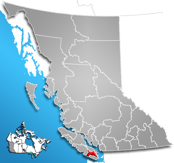
The Cowichan Valley Regional District is a regional district in the Canadian province of British Columbia is on the southern part of Vancouver Island, bordered by the Nanaimo and Alberni-Clayoquot Regional Districts to the north and northwest, and by the Capital Regional District to the south and east. As of the 2006 Census, the Regional District had a population of 76,929. The regional district offices are in Duncan.
Contents
Geography
The Cowichan Valley Regional District covers an area between the Stuart Channel and Saanich Inlet on the east coast of Vancouver Island and the southern part of the West Coast Trail, with Cowichan Lake located in its central region. It includes the Gulf Islands of Thetis, Kuper and Valdes. The total land area is 3,473.12 km² (1,340.98 sq mi).
Communities
Incorporated communities
- Duncan
- Ladysmith
- Lake Cowichan
- North Cowichan (Includes the communities of Chemainus, Crofton and Maple Bay
Native reserves
- Chemainus 13
- Claoose 4
- Cowichan 1
- Cowichan 9
- Cowichan Lake
- Halalt 2
- Kil-pah-las 3
- Kuper Island 7
- Lyacksun 3
- Malachan 11
- Malahat 11
- Oyster Bay 12
- Portier Pass 5
- Shingle Point 4
- Squaw-hay-one 11
- Theik 2
- Tsussie 6
- Wyah 3
Electoral areas
A
B
C
- Arbutus Ridge
- Cobble Hill
- Cherry Point
D
E
- Cowichan Station
- Eagle Heights
- Glenora
- Koksilah
- Sahtlam
F
- Honeymoon Bay
- Mesachie Lake
- Skutz Falls
G
H
- Diamond
- North Oyster
- Yellow Point
I
- Meade Creek
- Youbou
References
External links
- Cowichan Valley Regional District
- Imagine the Cowichan, Simon Fraser University's Imagine BC series
- "Cowichan Valley Regional District". BC Geographical Names. http://apps.gov.bc.ca/pub/bcgnws/names/25212.html.
 Subdivisions of British Columbia
Subdivisions Regions · Regional districts · Forest Regions and Forest Districts · School districts · Land DistrictsSettlements Urban centres Regional districts Alberni-Clayoquot · Bulkley-Nechako · Capital · Cariboo · Central Coast · Central Kootenay · Central Okanagan · Columbia-Shuswap · Comox Valley · Cowichan Valley · East Kootenay · Fraser Valley · Fraser-Fort George · Kitimat-Stikine · Kootenay Boundary · Greater Vancouver · Mount Waddington · Nanaimo · North Okanagan · Northern Rockies · Okanagan-Similkameen · Peace River · Powell River · Stikine Region (non-RD) · Skeena-Queen Charlotte · Squamish-Lillooet · Strathcona · Sunshine Coast · Thompson-Nicola Category:British Columbia ·
  Portal:British Columbia ·
  WikiProject:British Columbia
Coordinates: 48°50′00″N 124°13′00″W / 48.8333333°N 124.2166667°W
Categories:- Cowichan Valley Regional District
- Southern Vancouver Island
- Regional districts of the British Columbia Coast
- Cowichan Valley
Wikimedia Foundation. 2010.