- Northern Rockies Regional Municipality
-
Northern
Rockies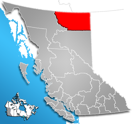
The Northern Rockies Regional Municipality, formerly the Northern Rockies Regional District, and before that the Fort Nelson-Liard Regional District, is a regional municipality in northeastern British Columbia, Canada. The regional district offices are located in the town of Fort Nelson, which is the only municipality of the district. The town comprises over 73 percent of the district's population of 6,147 (2006 census). The Regional Board consists of three rural directors and all four town councillors with the mayor of Fort Nelson acting as the Regional Chairman. The staff holds dual functions as employees of the regional district and the town of Fort Nelson.
The NRRD lies on the east slope of the Rocky Mountains, and comprises approximately 9.2% of the total area of the province of British Columbia, encompassing 85,151.45 square kilometres (32,877.16 sq mi). Its southern boundary is the 58th Parallel of latitude.[1]The Alaska Highway divides the district from southeast-to-northwest. The district is mostly made up of remote mountainous and forest areas, and includes thousands of rivers and streams, hundreds of lakes, an abundance of wildlife, and spectacular scenery.
The Northern Rockies Regional District was created in 1987 when the Peace River-Liard Regional District was divided along the 58th parallel into the Peace River Regional District and the Fort Nelson - Liard Regional District (later re-named the Northern Rockies Regional District).
Contents
Demographics
- Population:[2]
- 2006: 6,147 (2,492 private dwellings)
- 2001: 5,720
Electoral areas
The regional district has only two electoral areas, divided by the 124th Line of Longitude, which is intersected by the Liard River at the confluence of the Beaver River. Electoral areas are only relevant in the selection of the municipality's council, they are not used for administrative purposes; further, residents of Indian Reserves in these areas do not vote and are not part of municipal governance.
Northern Rockies A, British Columbia
Area A comprises the eastern half of the regional district.
Northern Rockies B, British Columbia
Area B comprises the western half, roughly, of the regional municipality and includes the communities of Liard River and Toad River. Residents of the Indian Reserves at those locations do not take part in municipal elections and their governments are separate from that of the regional municipality.
References
External links
- Northern Rockies Regional District & Town of Fort Nelson
- Northern BC Tourism
- 2001 Census Profile - Northern Rockies Regional District
- "Northern Rockies Regional District (rescinded)". BC Geographical Names. http://apps.gov.bc.ca/pub/bcgnws/names/54454.html.
 Subdivisions of British Columbia
Subdivisions Regions · Regional districts · Forest Regions and Forest Districts · School districts · Land DistrictsSettlements Urban centres Regional districts Alberni-Clayoquot · Bulkley-Nechako · Capital · Cariboo · Central Coast · Central Kootenay · Central Okanagan · Columbia-Shuswap · Comox Valley · Cowichan Valley · East Kootenay · Fraser Valley · Fraser-Fort George · Kitimat-Stikine · Kootenay Boundary · Greater Vancouver · Mount Waddington · Nanaimo · North Okanagan · Northern Rockies · Okanagan-Similkameen · Peace River · Powell River · Stikine Region (non-RD) · Skeena-Queen Charlotte · Squamish-Lillooet · Strathcona · Sunshine Coast · Thompson-NicolaCoordinates: 59°00′00″N 123°45′00″W / 59°N 123.75°W
Categories:- Northern Rockies Regional Municipality
- Regional districts of the British Columbia Interior
- Fort Nelson Country
- Liard Country
- British Columbia Interior geography stubs
- Population:[2]

Wikimedia Foundation. 2010.