- Taylor, British Columbia
Infobox Settlement
official_name = District of Taylor
other_name =
native_name =
nickname =
settlement_type = District
motto =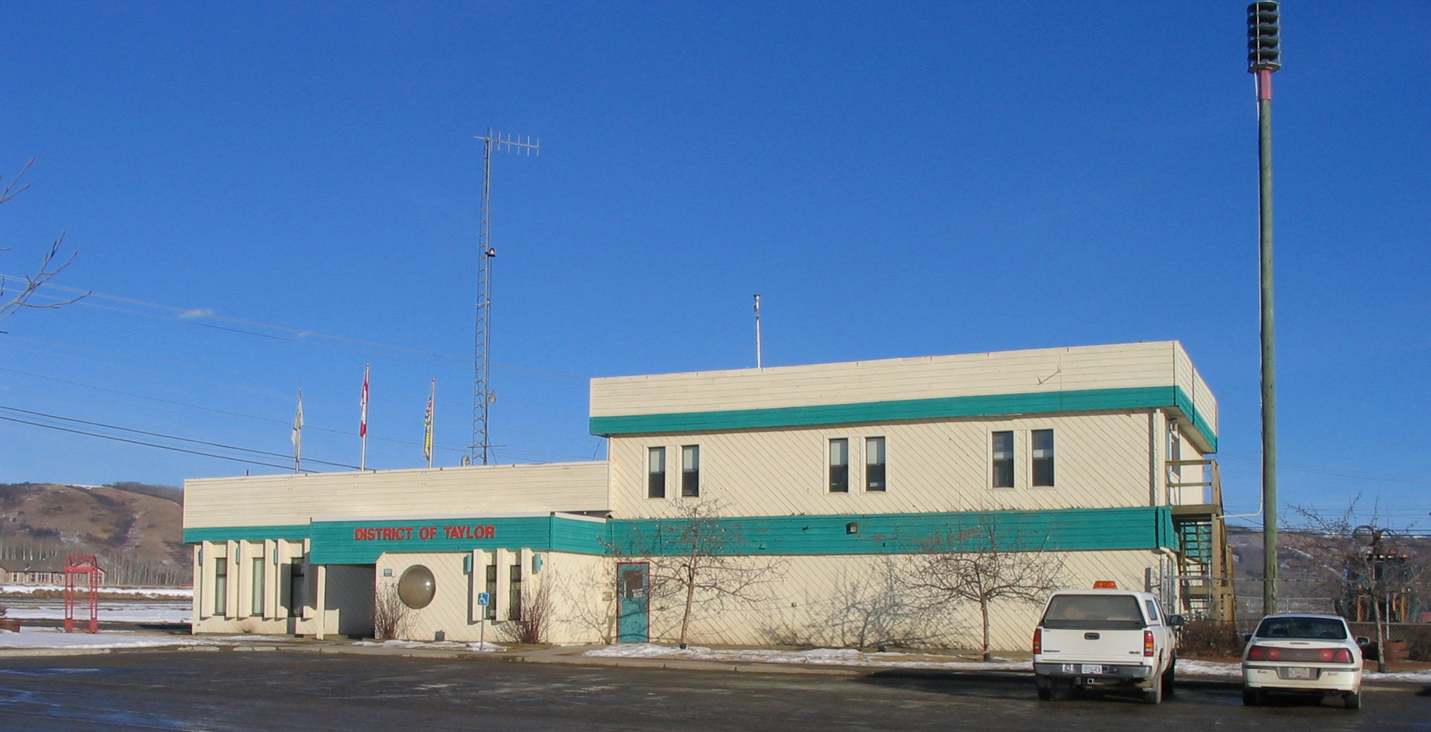
imagesize =
image_caption = Taylor town hall
flag_size =
image_
seal_size =
image_shield = Taylor, BC logo.png
city_logo =
citylogo_size =
mapsize =
map_caption =
mapsize1 =
map_caption1 =
image_dot_
dot_mapsize =
dot_map_caption = Location of Taylor inBritish Columbia
dot_x = 115 |dot_y=60
pushpin_
pushpin_label_position =
pushpin_map_caption =
pushpin_mapsize =
subdivision_type = Country
subdivision_name = CAN
subdivision_type1 = Province
subdivision_name1 = BC
subdivision_type2 = Regional District
subdivision_name2 = Peace River District
subdivision_type3 =
subdivision_name3 =
subdivision_type4 =
subdivision_name4 =
government_footnotes =
government_type =
leader_title = Mayor
leader_name = Fred Jarvis
leader_title1 = Governing Body
leader_name1 = Taylor District Council
leader_title2 = MP
leader_name2 =Jay Hill
leader_title3 = MLA
leader_name3 = Blair Lekstrom
leader_title4 =
leader_name4 =
established_title = Incorporated
established_date = 23 Aug 1958 (village)
established_title2 =
established_date2 = 21 Apr 1989 (district)
established_title3 =
established_date3 =
area_magnitude =
unit_pref =
area_footnotes =
area_total_km2 = 16.61
area_land_km2 =
area_water_km2 =
area_total_sq_mi =
area_land_sq_mi =
area_water_sq_mi =
area_water_percent =
area_urban_km2 =
area_urban_sq_mi =
area_metro_km2 =
area_metro_sq_mi =
area_blank1_title =
area_blank1_km2 =
area_blank1_sq_mi =
population_as_of = 2006
population_footnotes =
population_note =
population_total = 1,384
population_density_km2 =
population_density_sq_mi =
population_metro =
population_density_metro_km2 =
population_density_metro_sq_mi =
population_urban =
population_density_urban_km2 =
population_density_urban_sq_mi =
population_blank1_title =
population_blank1 =
population_density_blank1_km2 =
population_density_blank1_sq_mi =
timezone =Pacific Time Zone
utc_offset = -8
timezone_DST = Pacific Daylight Time
utc_offset_DST = -7
latd= 56|latm= 09|lats= 32|latNS=N
longd= 120|longm= 41|longs= 16|longEW=W
elevation_footnotes =
elevation_m = 500
elevation_ft =
postal_code_type = Postal code span
postal_code = V0C 2K0
area_code = +1-250
blank_name =
blank_info =
blank1_name =
blank1_info =
website = [http://www.districtoftaylor.com/ District of Taylor]
footnotes =British Columbia ,Canada , located on mile 36 of theAlaska Highway . Taylor, a member municipality of the Peace River Regional District, covers an area of about 17 km² (6 mile²) with 1,380 residents. [BC Stats (2 February 2007 ), [http://www.bcstats.gov.bc.ca/data/dd/facsheet/cf266.pdf "Taylor District Municipality" (pdf)] , "Community Facts".] Being just south of the much larger city of Fort St. John, there is a sizable amount of commuting and interaction between the two.The town sits on a plateau 60 m above the north bank of the Peace River. The first settler on the flat was a trapper named Herbert Taylor in 1911. The town incorporated in 1958 with industrial business beginning to locate there. Since then Taylor has remained a small town, even though it has developed a large industrial base and has become home to the annual World's Invitational Class 'A' Gold Panning Championships.
History
The town, and the Taylor Flats upon which the town is located, are named after Herbert Taylor, a fur-trader with the
Hudson's Bay Company who regularly met his Aboriginal trading counterparts on this river flat. In 1911 Taylor left his employers and took up residence on the flats with a few other squatters. The following year the federal government opened the area to homesteading and Taylor was granted the land upon which he had settled. [Harrison, Hal (1981) "Birth of the South Peace" in "Lure of the South Peace: Tales of the Early Pioneers" Dawson Creek: South Peace Historical Book Committee. pg. 273.] These early settlers were trappers with the first farm established by Henry Philip, fromGlasgow , who inherited buildings, equipment and land from his survey team when they left the area. In 1919, with the help of Taylor's nine children, along with those from a few American families who settled there, the provincial government opened the Taylor Flats School.These early settlers all came to the area through the
Peace River Country , through Grande Prairie and Pouce Coupe, and across the Peace River. Some decided to settle on the steep-sloped south side of the Peace River, an area that would become known as South Taylor. To cross the river acable ferry , which would prove to be accident-prone, was built in the 1920s but soon replaced with a motor-driven ferry. This ferry was used until 1942 when the U.S. Army came through the area building theAlaska Highway and constructed the 2,130 foot longPeace River Suspension Bridge . The highway connected the town to a rail station in Dawson Creek reducing the dependence on shipping along the river. The bridge suddenly collapsed on16 October 1957 with no injuries or fatalities. [ [http://collections.ic.gc.ca/north_peace/transport/02.07.html Collapsed Peace River Bridge] "History of the North Peace". URL accessed on5 February 2006 .] [http://www.districtoftaylor.com/itoolkit.asp?pg=Taylor's_History&k=1&pp=1 Taylor's History] "District of Taylor". URL accessed on5 February 2006 .] A new rail trestle, from the rail extension from Chetwynd to Fort St. John, was used while constructing the replacement Peace River Bridge, which still stands today.Major industrial development began in 1957, when Westcoast Energy (later
Duke Energy ) built the province's first gas processing plant, as well as a refinery and pipeline to Kamloops. [Westcoast Energy [http://www.westcoastenergy.com/about/history_gathering.html Gathering, Processing and Transportation] "History". URL accessed on5 February 2006 .] The community that formed around this industrial development was incorporated as a village on23 August 1958 and soonCanfor opened a planer mill. Meanwhile, x km (x miles) upstream, theW.A.C. Bennett Dam andPeace Canyon Dam s were completed in 1966 and 1980, resepectively, which had the effect of controlling the level and flow of the Peace River water flow making navigation and flood maintenance much easier.Following the construction of natural gas processing plant by Westcoast Energy in 1985, Fibreco Pulp opening its sawmill in 1988 the village to be re-incorporated into the District of Taylor in 1989. Despite the closure of the Petro-Canada refinery in 1991, economic growth continued throughout the decade as Westcoast Energy McMahon Gas Plant expanded in 1991 and added a cogeneration plant in 1993, Fibreco Pulp doubled its capacity in 1996, the Younger Natural Gas Liquids Extraction Plant (to extract water and sulphur from natural gas) was expanded in 1996, the Taylor Straddle plant (to extract ethane from natural gas) was built in 1997. [Salmo Consulting Inc. & Novagas Clearinghouse Ltd. (April 1997). [http://www.eao.gov.bc.ca/epic/output/documents/p35/1037135559555_9036ce24fbac4cf193849918a0c7f07d.pdf Applicatin for a Project Approval Certificate - Taylor Straddle Plant] ] Since 1993, the town of 1,300 people have built a new hockey arena, leisure skating arena, curling rink, and 18 hole golf course. Strong community pride also developed as demonstrated by the town placing first at the provincial level, in its small category, in the parks and gardens-oriented Communities in Bloom Competition in 1997 and second in the national competition in 1998. [ [http://www.communitiesinbloom.ca/participants/participants_pastnat.html 2001 - 1995 National Past Finalists] "Communities in Bloom". URL accessed
26 April 2006 ] Other local projects have included building a memorial garden and cenotaph in 2000 dedicated to the 341st Engineers of the U.S. Army corps of Engineers who were stationed on the Taylor Flats in 1942 during the construction of the Alaska Highway and the Peace River Suspension Bridge.Demographics
The 1961 Canadian census, the first to include Taylor as a distinct subdivision, counted 438 people.BC Stats, [http://www.bcstats.gov.bc.ca/data/pop/pop/mun/Mun2171.asp British Columbia Municipal Census Populations, 1921-1971] ,
November 27 2005 .] During the subsequent five years the population rose 36% to 595 people but rose only a further 2% to 605 people by 1971. The population spiked in the late-1970s during the construction of the Peace Canyon Dam and sawmills were opened in town. After the dams were built businesses left and the population decline in the early-1980s. Since 1985 a series of large industrial businesses opened facilities in town creating a steady population rise since then.According to the 2001 Canadian census, only 4% of Taylor's population between 20 and 64 years old graduated from a university, much less than the 24% provincial average and, likewise, 38% did not graduate from secondary school, twice the provincial average. Of Taylor's 625 person labour force, 38%, or 235 people (215 males and 15 females), are employed as tradesmen, transport and equipment operators and related occupations. With Fort St. John only 15 km (9 miles) north of Taylor it is within commuting distance for employees and shoppers. Taylor itself has little commercial retail stores, including no grocery store, but commute to Fort St. John for retail needs. [District of Taylor (2006) [http://www.districtoftaylor.com/itoolkit.asp?pg=Taylor_Market_Survey Taylor Market Survey] Retrieved10 February 2007 .] The larger center also provides more facilities for lower income families, giving Taylor a lower incidence of low income.Culture and recreation
Despite its small population base and its proximity to a much larger urban center Taylor has an ice arena, a curling rink, indoor swimming pool, irrigated baseball diamonds, a dirt race track, and a golf course. The District Ice Center opened in 1993 and consists of an ice hockey rink and leisure skating rink, both of which are used for roller hockey and trade shows and conventions in the summer. The four sheet curling rink is used as a swimming pool in the summer. The district's newest facility, built in 2001, is a CDA$1.2 million multi-purpose community hall and gymnasium. [District of Taylor. [http://www.districtoftaylor.com/itoolkit.asp?pg=Community_Involvement Communities in Bloom: Community Involvement] ] The 320 acre, 18-hole Lone Wolf Golf Course opened in 1995 at a cost of CDA$3.5 million and is managed by the district. Meandering around the course, and by agricultural fields and a community forest, is the 4.2 km Participaction Trail. [District of Taylor. [http://www.districtoftaylor.com/itoolkit.asp?pg=Outdoor_Recreation Outdoor Recreation: Participaction Trail] ] In the winter the golf course and its trails are used for cross-country skiing, snowshoeing and other winter activities. Since 2004 the district has also operated Peace Island Park with its boat launches, campsites, and facilities for recreational outdoor events. Annual events in the town include dogsled racing in January, a
conformation dog show in May, and the Invitational Class 'A' Gold Panning Championships in the summer. The gold panning competition is a two day event that has been held in Taylor annually since 1972 and includes advanced and amateur competitions, a parade and other community-wide events. [District of Taylor. [http://www.districtoftaylor.com/itoolkit.asp?pg=Gold_Panning Taylor Events: Gold Panning] ] Also, to preserve its heritage, several pioneer log houses, such as the visitor information centre, where a replica ofAlexander Mackenzie 'sbirch bark canoe is displayed, and Peace Island Park meeting hall, have been restored and are used today.Government and politics
The District of Taylor has a
council-manager form ofmunicipal government . At-large elections are held every three years to elect four municipal councillors, a mayor who also represents Taylor at the Peace River Regional District, and one school board trustee (to the school district). In the19 November 2005 civic election Fred Jarvis was re-elected mayor byacclamation . [Reaburn, Adam [http://www.fsjnow.com/?action=nc&qn=FSJN-Main_Page&idnews=2960 Municipal Election Results] , "Fort St. John Now!",November 19 2005 .]Taylor is situated in the
Peace River South provincial electoral district and is represented byBlair Lekstrom in theLegislative Assembly of British Columbia . Lekstrom was first elected as aMember of the Legislative Assembly in the 2001 provincial election taking 78% of votes cast at the Taylor polls [Elections BC (2001) [http://www.elections.bc.ca/elections/sov01/pcs.pdf Peace River South Electoral District (pdf)] , "Statement of Votes, 2001",November 18 2005 .] and re-elected in 2005 with 73% support.Elections BC (2005) [http://www.elections.bc.ca/elections/sov05/pcs.pdf Peace River South Electoral District (pdf)] , "Statement of Votes, 2005",November 18 2005 .] For the 1996 election, and those previous, Taylor was part of thePeace River North provincial electoral district which electedRichard Neufeld of the BC Reform Party. [Elections BC (1996) [http://www.elections.bc.ca/elections/sov96/va/sov96_pcn.htm Peace River North Electoral District] , "36th Provincial General Election - May 28, 1996", 5,November 17 2005 .]Federally, Taylor is located in the
Prince George—Peace River riding, which is represented in theCanadian House of Commons by Conservative PartyMember of Parliament Jay Hill . Hill was first elected in 1993, then re-elected in 1997, 2000, 2004, and 2006 with 82%Elections Canada [http://www.elections.ca/content.asp?section=gen&document=index&dir=rep/37d&lang=e&textonly=false 36th and 37th General Elections: Official Voting Results: Poll-by-poll Results] , "Elections Canada On-Line|General Information",January 22 2006 . (Requires user to download database.] , 83%, 79%Elections Canada (2004) [http://www.elections.ca/scripts/OVR2004/default.html Thirty-eighth General Election 2004 — Poll-by-poll results] , "Official Voting Results/Résultats officiels du scrutin",November 18 2005 . (Requires navigation to Prince George—Peace River)] and 80% [http://www.elections.ca/scripts/OVR2006/data/59022.pdf 39th General Election Validated Poll-by-Poll Results.] Elections Canada. URL accessed on 12 February 2007.] support from Taylor polls, respectively. Before Hill the riding was represented, from 1972 to 1993, by Frank Oberle of the Progressive Conservative Party who served as Minister of State for Science and Technology from 1985 to 1989 and Minister of Forestry from 1990 to 1993. [Library of Parliament (2006) [http://www.parl.gc.ca/information/about/people/key/bio.asp?Language=E&query=1486&s= Oberle, The Hon. Frank, P.C.] , "Federal Political Experience",January 22 2006 . (Requires user to download database.]References
;General referencesCalverley, Dorthea. [http://www.calverley.ca/Part15-Fort%20St%20John%2C%20etc/15-18.html The Story of Taylor’s Flat to 1957] "Calverley Collection".
External links
* [http://www.discoverthepeacecountry.com/htmlpages/taylorbc.html Discover the Peace Country - Taylor]
Geographic Location (8-way)
Centre = Taylor
North = Baldonnel
Northeast = Worsley
East = Hines Creek
Southeast =Peace River Corridor Provincial Park
South = Dawson Creek
Southwest = Chetwynd
West = Hudson's Hope
Northwest = Fort St. John

Wikimedia Foundation. 2010.