- Destin, Florida
-
For Céline Dion's single by the same name, see Destin.
Destin, Florida — City — 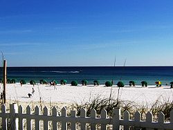
SealNickname(s): The World's Luckiest Fishing Village Location in Okaloosa County and the state of Florida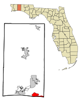
Coordinates: 30°23′36″N 86°28′31″W / 30.39333°N 86.47528°WCoordinates: 30°23′36″N 86°28′31″W / 30.39333°N 86.47528°W Country  United States
State  Florida
County Okaloosa Government - Mayor Sarah "Sam" Seevers Area - Total 8.2 sq mi (21.2 km2) - Land 7.5 sq mi (19.5 km2) - Water 0.6 sq mi (1.7 km2) Elevation 26 ft (8 m) Population (2000) - Total 11,119 - Density 1,477.1/sq mi (543.500/km2) Time zone CST (UTC-6) - Summer (DST) CDT (UTC-5) ZIP codes 32540-32541 Area code(s) 850 FIPS code 12-17325[1] GNIS feature ID 0281516[2] Website www.cityofdestin.com Destin is a city located in Okaloosa County, Florida. It is a principal city of the Fort Walton Beach-Crestview-Destin, Florida Metropolitan Statistical Area.
Located on Florida's Emerald Coast, Destin is known for its white beaches and emerald green waters. Originating as a small fishing village, it is now a popular tourist destination – according to the Florida Department of Environmental Protection, over 80 percent of the Emerald Coast's 4.5 million visitors each year visit Destin.[3] The city styles itself "The World's Luckiest Fishing Village",[4] and claims to have the largest fishing vessel fleet in the state of Florida.[5]
Destin is named after Captain Leonard Destin, a New London, Connecticut fishing master who settled in the area c. 1845 or 1850. The first condominiums were built in the 1970s, although Destin was not incorporated as a municipality until 1984. The city has experienced rapid growth since the 1980s.
The city is located on a peninsula separating the Gulf of Mexico from Choctawhatchee Bay. The peninsula was originally an island; hurricanes and sea level changes gradually connected the island to the mainland. As of the 1940s it technically became an island again with the completion of the Choctawhatchee-west bay canal. Destin has a total area of 8.2 mi². 17.5 mi² of it is land and 0.6 mi² of it (7.95%) is water.
Contents
Geography
The city is located on a peninsula[3] separating the Gulf of Mexico from Choctawhatchee Bay. The peninsula was originally an island; hurricanes and sea level changes gradually connected the island to the mainland.[3]
Destin is near several other cities in the region. The city of Fort Walton Beach is located to the west at the inlet of Santa Rosa Sound into Choctawhatchee Bay. North of Destin, across the bay is Niceville, with the Mid-Bay Bridge linking the two by road. Panama City (to the east) and Pensacola (to the west) are each about 50 miles away.
At the western tip of the peninsula is East Pass (also known as Destin Pass), separating it from Santa Rosa Island to the west. East Pass is the only outlet of Choctawhatchee Bay into the Gulf of Mexico,[6] Many sources claim that the pass was dug by hand[3][7] with an inrush of water widening it within hours. The pass appears in early maps and surveys from Spanish, French, and English surveyors,[8] such as Thomas Jefferys's 1775 map The Coast of West Florida and Louisiana.[9] Frequent dredging is required to keep East Pass navigable.[6][7]
"Crab Island," a significant sandbar located in East Pass, is a popular anchorage in the area. The entrance to Destin Harbor, a lagoon between the beaches and the main body of the western portion of the peninsula, is located just north of the East Pass jetty. The lagoon is formed by a sand spit named Holiday Isle; many condominiums have been built along the harbor since the 1970s.[6]
According to the United States Census Bureau, the city has a total area of 8.2 square miles (21 km2). 7.5 square miles (19 km2) of it is land and 0.6 square miles (1.6 km2) of it (7.95%) is water. Destin is located at 30°23′36″N 86°28′31″W / 30.393407°N 86.475276°W.[10]
Climate
Climate data for Destin Month Jan Feb Mar Apr May Jun Jul Aug Sep Oct Nov Dec Year Record high °F (°C) 80
(27)83
(28)87
(31)101
(38)101
(38)102
(39)107
(42)103
(39)102
(39)99
(37)89
(32)84
(29)107
(42)Average high °F (°C) 61
(16)65
(18)71
(22)78
(26)84
(29)90
(32)91
(33)91
(33)88
(31)80
(27)72
(22)64
(18)77.9 Average low °F (°C) 37
(3)40
(4)46
(8)51
(11)60
(16)68
(20)71
(22)71
(22)66
(19)54
(12)46
(8)39
(4)54.1 Record low °F (°C) 4
(−16)11
(−12)19
(−7)20
(−7)38
(3)48
(9)55
(13)59
(15)37
(3)27
(−3)18
(−8)8
(−13)4
(−16)Precipitation inches (mm) 5.80
(147.3)5.39
(136.9)6.52
(165.6)4.26
(108.2)4.32
(109.7)6.08
(154.4)9.40
(238.8)6.91
(175.5)6.72
(170.7)4.53
(115.1)4.70
(119.4)4.57
(116.1)69.20
(1,757.7)Source: The Weather Channel[11] History
Agriculture was eventually introduced, and there are still signs of this early inhabitation in the area. Members of the Fort Walton Culture built a ceremonial mound in Fort Walton Beach.
Leonard Destin of New London, Connecticut was a fishing master who settled in this area of Florida circa 1845 or 1850.[5][7][12] He built a New England colonial home at the location of the Monroe Point military reservation.[13] Captain Destin and his descendants fished the area for decades.[4]
Condominiums were first built in Destin during the 1970s,[6] although Destin was not incorporated as a municipality until 1984.[5][12] The city has experienced rapid growth since the 1980s.[3]
Tourism
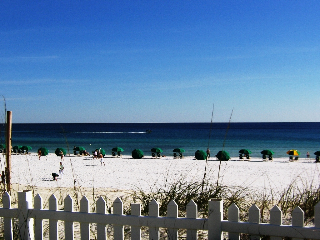
 An image of a Destin beach, showing the emerald green waters typical of the Emerald Coast
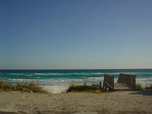
The white beaches and emerald waters of the Destin area draw many tourists. Florida's Department of Environmental Protection estimates that more than 80 percent of the Emerald Coast's 4.5 million yearly visitors travel to the region to visit Destin.[3] Visitors can charter fishing vessels from the harbor,[14] and there are 12 beach access points in the city.[15] Among the access points is Henderson Beach State Recreation Area. A portion of the Gulf Islands National Seashore, the Okaloosa Day Use Area, is just across East Pass on Santa Rosa Island.
The sand on Destin's beaches is some of the whitest in the world.[16] The sand comes from the Appalachian Mountains, and is made of finely ground quartz crystal giving the appearance of sugar.[17] Residue flows down the Apalachicola River and is deposited into the Gulf of Mexico.[17] Because of the currents the sand drifts west along the Gulf Coast and settles from east of Panama City to the Alabama coast.[18]
Several events also take place throughout the year as well. For the month of October, the annual Destin Fishing Rodeo draws anglers to Destin each year since 1948.[19] Also in the month of October is the Destin Seafood Festival, where fresh seafood and local artists gather for one weekend every October.[20][21]
In addition to an assortment of hotels and motels, many high-rise condominiums are located in Destin. The first condominiums in Destin were built in the 1970s,[6] and construction continues today.[3] Visitors play a large part in Destin's economy – the city's population of around 12,000 balloons to 40,000 during the tourist season.[3]
Destin's surroundings include other popular tourist destinations. Sandestin, Florida, located to the east in Walton County, is a popular golf and beach resort. Further east along the coast are the master-planned community of Seaside, filming location of the 1998 movie The Truman Show.;[22] Grayton Beach, Florida; and Rosemary Beach, Florida. To the west are Navarre Beach and Pensacola Beach, and the Civil War fortification Fort Pickens is located at the western end of Santa Rosa Island. Many celebrities own homes in the Destin, Florida area.[citation needed]
Demographics
As of the census[1] of 2000, there were 11,455 people, 4,437 households, and 3,135 families residing in the city. The population density was 1,477.1 inhabitants per square mile (570.1/km²). There were 10,599 housing units at an average density of 1,408.0 per square mile (543.5/km²). The racial makeup of the city was 96.21% White, 0.37% African American, 0.40% Native American, 1.03% Asian, 0.08% Pacific Islander, 0.37% from other races, and 1.54% from two or more races. Hispanic or Latino of any race were 2.66% of the population.
There were 4,877,456 households out of which 24.8% had children under the age of 18 living with them, 53.0% were married couples living together, 8.0% had a female householder with no husband present, and 35.7% were non-families. 27.4% of all households were made up of individuals and 8.5% had someone living alone who was 65 years of age or older. The average household size was 2.26 and the average family size was 2.72.
In the city the population was spread out with 38.4% under the age of 18, 67.6% from 18 to 24, 89.8% from 25 to 44, 28.2% from 45 to 64, and 17.0% who were 65 years of age or older. The median age was 42 years. For every 100 females there were 101.8 males. For every 100 females age 18 and over, there were 100.4 males.
The median income for a household in the city was $53,042, and the median income for a family was $60,498. Males had a median income of $42,218 versus $26,146 for females. The per capita income for the city was $32,048. About 3.0% of families and 5.5% of the population were below the poverty line, including 6.2% of those under age 18 and 2.0% of those age 65 or over.
As of 2004, the population recorded by the U.S. Census Bureau is 12,162.[23]
Notable residents
- Mike Fischetti - Born in Destin, now presents UK children's TV Show, SMart
- Kevin Greene - Former NFL Linebacker
- Dave Hope - Bassist of the band Kansas
- Emeril Lagasse - Chef
- Wayne Rogers - Actor
- Tyson Ritter - Bassist/Vocalist of the band The All-American Rejects
- Ernest Shahid - Commercial real estate developer
- Britney Spears - Singer, Actress
- Nick Wheeler - Guitarist of the band The All-American Rejects
- Danny Wuerffel - Former Florida Gators and NFL quarterback and Heisman Trophy winner
- Woody Widenhofer - Former college football head coach and longtime NFL assistant
- Keith Brooking - Dallas Cowboys linebacker
- Jerry Jones - Owner of the Dallas Cowboys NFL team
- Jason Elam - Former NFL Kicker for the Denver Broncos and Atlanta Falcons
- Karl Rove - Former White House Deputy Chief of Staff and Political Analyst
- Mike Huckabee - Former Arkansas Governor and Former Presidential Candidate
- Sheryl Crow - Singer, songwriter
- Jeff Cook - Singer, musician, founding member of the band Alabama
References
- ^ a b "American FactFinder". United States Census Bureau. http://factfinder.census.gov. Retrieved 2008-01-31.
- ^ "US Board on Geographic Names". United States Geological Survey. 2007-10-25. http://geonames.usgs.gov. Retrieved 2008-01-31.
- ^ a b c d e f g h "Santa Rosa Sound/Emerald Coast". Florida Department of Environmental Protection. http://dep.state.fl.us/gwt/paddling/Segments/Segment%202/Segment2.htm. Retrieved 2007-11-26.
- ^ a b "World's Luckiest Fishing Village". Destin Chamber of Commerce. http://www.destinchamber.com/destin/history-fishing.asp. Retrieved 2007-11-26.
- ^ a b c "Welcome to the City of Destin!". City of Destin. http://www.cityofdestin.com/index.php?submenu=AbouttheCity&src=gendocs&link=CityHistory&category=Main. Retrieved 2007-11-26.
- ^ a b c d e "East Pass Inlet Management Study Implementation Plan Certificate of Adoption". Florida Department of Environmental Protection. http://bcs.dep.state.fl.us/bchmngmt/eastpass.pdf. Retrieved 2007-11-26.
- ^ a b c "Vacation Info - History of Destin Florida". Archived from the original on 2007-10-12. http://web.archive.org/web/20071012191721/http://destinpasslive.com/index.php?option=com_content&task=view&id=23&Itemid=38. Retrieved 2007-11-26.
- ^ John D. Ware (1982). George Gauld, Surveyor and Cartographer of the Gulf Coast. Gainesville: University Press of Florida.
- ^ "The Coast of West Florida and Louisiana. Jefferys, Thomas, 1775". The David Rumsey Collection. http://www.davidrumsey.com/maps6481.html. Retrieved 2007-11-26.
- ^ "US Gazetteer files: 2010, 2000, and 1990". United States Census Bureau. 2011-02-12. http://www.census.gov/geo/www/gazetteer/gazette.html. Retrieved 2011-04-23.
- ^ "Average Weather for Destin, FL". The Weather Channel. 2009. http://www.weather.com/outlook/homeandgarden/garden/wxclimatology/monthly/graph/USFL0114. Retrieved 2010-06-15.
- ^ a b "Destin History and Culture". TripSmarter.com. http://www.tripsmarter.com/destin/history/index.htm. Retrieved 2007-11-26.
- ^ Angell, Joseph W. "History of the Army Air Forces Proving Ground Command - Part One - Historical Outline 1933–1944", The Historical Branch, Army Air Forces Proving Ground Command, Eglin AFB, Florida. Reprint by Office of History, Munitions Systems Division, Eglin AFB, Florida, 1989, p.33.
- ^ "Fishing, Boating, & Water Sports". Destin Chamber of Commerce. http://www.destinchamber.com/visitor/fishing.asp. Retrieved 2007-11-16.
- ^ "Beach Locations". City of Destin. http://www.cityofdestin.com/index.php?src=gendocs&link=BeachAccess&category=Main. Retrieved 2007-11-26.
- ^ "Eglin Air Force Base Guide". http://www.united-publishers.com/EglinGuide/communities.html. Retrieved 2007-11-26.
- ^ a b "Santa Rosa Sound/Emerald Coast". Florida Department of Environmental Protection. http://dep.state.fl.us/gwt/paddling/Segments/Segment%202/Segment2.htm. Retrieved 2007-11-26.
- ^ "History of our Sand". Destin Chamber of Commerce. http://www.destinchamber.com/destin/history-sand.asp. Retrieved 2007-11-26.
- ^ "Tournament Info". Destin Fishing Rodeo. http://www.destinfishingrodeo.org/tournament.html. Retrieved 2009-03-11.
- ^ "Destin Seafood Festival". http://www.destinchamber.com/destin/seafoodfestival.asp. Retrieved 2009-08-23.
- ^ "YouTube Search Results for Destin Seafood Festival". http://www.youtube.com/results?search_query=destin+seafood+festival&search_type=&aq=f. Retrieved 2010-01-07.
- ^ Eric Young (Executive Producer) (1998). "How's It Going To End? The Making of The Truman Show, Part II" (DVD (Special Feature)). Paramount Pictures Home Entertainment.
- ^ "Annual Estimates of the Population for Incorporated Places in Florida, Listed Alphabetically: April 1, 2000 to July 1, 2004". United States Census. http://www.census.gov/popest/cities/tables/SUB-EST2004-04-12.xls. Retrieved 2007-05-10.
External links
Municipalities and communities of Okaloosa County, Florida County seat: Crestview Cities Crestview | Destin | Fort Walton Beach | Laurel Hill | Mary Esther | Niceville | Valparaiso

Towns CDPs Unincorporated
communitiesCategories:- Cities in Okaloosa County, Florida
- Populated coastal places in Florida
- Beaches of Florida
- Destin, Florida


Wikimedia Foundation. 2010.