- Daulat Beg Oldi
-
This article is about the military base in northern India. For the MMORPG game, see Dragon Ball Online.
Daulat Beg Oldi — military base — Coordinates 35°23′24″N 77°55′30″E / 35.390°N 77.925°ECoordinates: 35°23′24″N 77°55′30″E / 35.390°N 77.925°E Country India State Jammu and Kashmir District(s) Leh Time zone IST (UTC+05:30) Area
• 5,100 metres (16,700 ft)
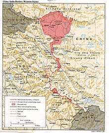 Daulat Beg Oldi is in northernmost Ladakh.
Daulat Beg Oldi (also Oldie, DBO), Ladakh, state of Jammu & Kashmir, India is an historic camp site and current military base located on an ancient trade route connecting Ladakh to Yarkand in Xinjiang, China. The Chip Chap River flows by Daulat Beg Oldi from east to west.
Contents
Location and Physical Conditions
Daulat Beg Oldi lies at the easternmost point of the Karakoram Range in a cold desert region in the far north of India, just 8 km south of the Chinese border and 9 km northwest of the Aksai Chin Line of Actual Control between China and India. Other than Siachen Glacier military bases, it is India's northernmost built-up area. The nearest inhabited town is Murgo to the south, which has a small population of Baltis who primarily depend on apricot farming and yak rearing.
The government in 2001 first announced plans to construct a motorable road from Leh to its end at Daulat Beg Oldi.
Temperature plummets as low as -30 C in the winters. The weather deteriorates frequently with strong icy winds lashing much of DBO. DBO has very little if any vegetation or wildlife. Communication is possible only through INMARSAT (satellite) phones.
History
The place is named after Daulat Baig Oldi, a 16th century Yarkandi nobleman who is supposed to have died at this place after descent from the Karakoram Pass, which is 17 kilometers to the northwest on the Indo-Chinese border. This route was used by caravans of traders traveling between India and Central Asia. It used to be a stopping point for the caravans traveling along the Silk Road. India and China sealed their borders after the 1962 India-China War, ending most of the cross-border trade. In modern times, the place has not been known to have any permanent civilian population.[1]
Daulat Beg Oldi Advanced Landing Ground
Daulat Beg Oldi Advanced Landing Ground 
IATA: none – ICAO: none Summary Airport type Military Operator Indian Airforce Location Ladakh, India The Indian Army maintains helipads and a gravel air strip here, the highest airstrip in the world. Routine sorties are carried out using An-32 aircraft to provide relief and supplies to the troops stationed nearby. [2]
History
The base was established during the Sino-Indian conflict in 1962. It was operated with American-supplied Fairchild Packets from 1962 to 1966, when it had to be closed down suddenly when an earthquake caused loosening of the surface soil, making the area unsuitable for fixed-wing aircraft.[3]
On 31 May 2008, the Indian Air Force made the air base more fully operational when a AN-32 of the IAF landed.[4]
See also
- Fukche Advanced Landing Ground
- Siachen Glacier
- Thoise
References
- ^ "The Himalayas - Ladakh Himalayas - Villages and Plateus - Shyok Valley". http://library.thinkquest.org/10131/ladakh_shyok_burtsa_ao.html. Retrieved 31 May 2008.
- ^ "IAF Aircraft lands at the highest airstrip in the world". The Times Of India. 31 May 2008. http://economictimes.indiatimes.com/articleshowarchive.cms?msid=3088577. Retrieved 31 May 2008.
- ^ "IAF reopens old airbase in Ladakh region". The Times Of India. 31 May 2008. http://timesofindia.indiatimes.com/IAF_reopens_old_airbase_in_Ladakh_region/rssarticleshow/3088683.cms. Retrieved 31 May 2008.
- ^ "IAF reopens old air base near China border". The Times Of India. 31 May 2008. http://timesofindia.indiatimes.com/India/IAF_reopens_old_air_base_in_Ladakh/articleshow/3088108.cms. Retrieved 31 May 2008.
Ladakh Passes Khardung La · Sasser Pass · Karakoram Pass · Lachulung La · Tanglang La · Chang la · Marsimik La · Rezang La · Zoji La · Pensi La · Shingo LaValleys Cities and Towns Rivers, glaciers and lakes Sutlej · Beas · Ravi · Shyok · Chenab · Indus · Zanskar · Tsarap · Doda River · Suru River · Markha River
Siachen Glacier · Drang-drung · Rimo
Tso Moriri · Pangong TsoMonasteries Alchi · Bardan · Basgo · Chemrey · Diskit · Hanle · Hemis · Hundur · Korzok · Karsha · Lamayuru · Likir · Lingshed · Mashro · Matho · Mulbekh · Namgyal Tsemo · Phugtal · Phyang · Rangdum · Rizong · Sani · Sankar · Saspul · Shey Monastery · Spituk · Stakna · Stok · Stongdey · Takthok · Thikse · Tonde · Wanla · Zangla · ZongkulSee also History of Ladakh · Shanti Stupa · Leh-Manali Highway · Lahaul and Spiti · Tourism in Ladakh · Ladakhi language · Wildlife of Ladakh · * Curious BRO Roadsigns · * Geography of Ladakh · Saltoro Kangri · More plainsCategories:- Geography of India
- Indian Air Force bases


Wikimedia Foundation. 2010.