- Namli Maira
-
Namli Maira — Union council — Location of Namli Maira (highlighted in red) within Abbottabad district, the names of the neighbouring districts to Abbottabad are also shown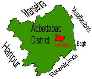
Coordinates: 34°07′N 73°23′E / 34.117°N 73.383°ECoordinates: 34°07′N 73°23′E / 34.117°N 73.383°E Country  Pakistan
Province Khyber-Pakhtunkhwa District Abbottabad Tehsil Abbottabad Government - Nazim Sardar Shakeel Ahmed[1] - Naib Nazim Tauseer Ahmed Population - Total 8,900 Namli Maira is one of the 51 union councils of Abbottabad District in Khyber Pakhtunkhwa province of Pakistan.[2]
Contents
Location
Namli Maira is a mountainous rural area located in Abbottabad District (34°07′00″N 73°23′00″E / 34.116667°N 73.383333°E). It takes its name from the two largest hamlets in the Union Council—Namli and Maira. These settlements are nestled on mountain ridges about 20 kilometres from the city of Abbottabad.
A metaled road connects Namli Maira to the main Abbottabad—Nathia Gali road near Azizabad (Bagnotar) and is an alternate route to reach Nathia Gali from Abbottabad. It is some 3 kilometres away from the main road (Bagnotar)
The highest peak in Abbottabad District, Miranjani, is located in Namli Maira.
2005 earthquake
On 8 October 2005 an earthquake of magnitude 7.6 struck the northern areas and Kashmir, causing significant damage to housing and some deaths. Aftershocks were felt through December.
Administration
The Union Council is administratively divided into Dhaki Khaiter, Namli Maira, Noormang, and Panghora areas[1].
Villages
Villages of Namli Maira include[citation needed]
- Namli
- Maira khurd
- Maira kalan
- Noor mang
- Jaster
- Chum
Mohallas
Mohallas of Namli Maira include[citation needed]
- Baglain
- Hill
- Proper Namli
- Maira Khurd
- Nakrorri
- Har
- Kandrali
- Dana
- Mundrehi
- Bhandila
- Darwaza
- Kutli
- Chumb
- Lasan Dhiba
- Derah
- Paghar
- Karmalla
- Maira Kalan
- Baghnian
- Jaster
- Besala
- Noor Nala Jastar
- Larri
- Tandi
- Danna
- Upper Kallah
- Lower Kallah
- Khuni Back-Nali
- Thurry
- Upper Maira
- Lower Maira
- Nakrorhi
- Kharhian
- Plutt Khana
- Kalse
- Jabrain
- Bari
- Pull Maira
- Chanati
- Nallah (Upper Maira)
- Chanala
- Bandiali
- garandi
- harjola
- Kholian
- Nala (near Marinjani)
- Basalnaka (upper maira kalan)
The most highly populated Mohallas are Maira Klan, Jastar, Proper Namli, and Maira Khurd,paghar and karmala.[citation needed] JastarBesala):(Very near to "Barhagali"Peshawar Unerersity Campus(Summer).Its link over from "Charrian",Nathia Road to Besala-Jastar.
Livelihood
The main occupation of the people is subsistence farming and cattle breeding. Farmers cultivate one crop per season as climatic conditions do not permit double cropping. The other occupation is cattle breeding. Cows, sheep and goat are kept for supplying milk for the daily use of the households. Bullocks are used to work the plough.
Poverty has forced many people to seek economic opportunities in the plains. Besides earning livelihood doing odd jobs in nearby towns, many have joined the army and civil services. Hotels in the nearby hill towns of Nathia gali ,Ayubia and Murree provide another source of employment to the locals. After turmoil in Swat, Namli Maira is gradually becoming a favored tourist destination from down country.
Ethnic groups
The people of Namli Maira are all Muslims. About 80% belong to the Karlal (Sardar) tribe.Other tribes in this area include Turks [Pakistani Turks], Awan, Malik, Abbasi and a handful of Mughals. Majority of people belong to karlal tribe and are sunni Muslims.
Climate and crops
As this area is away from sea and is above the sea level its winters are extreme. Winter lasts from October to April. April tends to be quite pleasant as the climate is temperate.The summer season is very pleasant and humid the temperature rises maximum to 25-30 degree,due to which it is good picnic spot.
From mid July to mid August people enjoy the fifth season, monsoon, which provides relief after the hot months (i.e. May and June). Farming is the main occupation of the people.The farming is done by oxen in the remote area of village but in proper village i.e. namli is ploughed by machinery because of accessibility.the two crops are grown there i.e. rabi and kharaif. The major rabi crop grown here are potato and maize.the kharaif crop grown there is only wheat but in very small area of village.There are two main purpose of this crop.
1:for cattle
2:For grain
Some vegetable are also found here like turnip, radish, peas, pumpkin, beans and mustard.
Fruits
Fruit like pear, apple, black grapes, grapes, fig, peach, damson plum, mulberry, wild fig, lemon, apricot, charry are found in abundance in Namli Maira. As the hill people lack awareness about the markets, they are unable to get a proper return. These fruits only meet the requirement of local people.
Forests
Most of the area of these hilly hamlets is covered with trees. Peaks are covered with evergreen trees including pine, walnut, oak and maple trees. Herbs, shrubs, wild flowers and thorny bushes can be seen in abundance. Goats and other pet animals graze the pastures. Wood is the primary source of fuel and home construction.
Fuel
Wood is used as fuel, it is the primary source of fuel. Gas cylinder are also used as fuel but in very low quantity.
Education
Literacy Rate: Namli Maira village has one of the highest literacy rates for the district. The literacy rate of Namli Maira is about 75%. Government and private schools cater to the elementary educational needs of the residents. There are Primary schools for boys and girls, Government Boys High School and Girls High School.A number of private schools are also available, providing the good education at their level. Among them ,Habib Public School, Model Public School, AL-falah public school(chanati) and Iqra Public School(upper maira kalan) are the most popular private schools.
At the recently opened S.A Zeb Versatile Academy, the idea is to provide quality education at kindergarten level.[3]
Tourism
Since the earthquake of 2005 the tourists prefer Nathi Gali and surrounding areas like Namli Maira, Kala Bagh, Thandiani and Mushkpuri. Approach to Namli Maira is same from Murree and "Abbottabad" (from both side 32 KM).Miranjani also known as "Choki" is one of the most popular sites of Namli Maira.The height of Mirajani is approximately 9,000 feet above the sea level. There is an old track adjacent to Mirajani peak which connects Nathia Gali to Thandiani. Along the track lies a British-era forest rest house, called Dagri Bangla by the locals. Building's location (in the middle of thick forest), colonial style of construction and remoteness accord an aura of mystery to it.
Languages
The mother language of the people of Namli Maira is Hindko They can also speak and understand Urdu pashto and English. The elderly people of the village can also speak and understand Persian.
References
- ^ a b District Profile: Abbottabad, Earthquake Reconstruction and Rehabilitation Authority
- ^ Administrative Units of District Abbottabad
- ^ educational comity
Administrative divisions of Abbottabad District Capital 
Tehsils Union councils Abbottabad Central · Sheikh-ul-Bandi · Bagh · Bagnotar · Bakot · Baldheri · Bandi Atti Khan · Banda Pir Khan · Beerangali · Berote Kalan · Boi · Chamhad · Dalola · Dewal Manal · Dhamtour · Ghari Phulgran · Goreeni · Haveliani Urban · Jarral · Jhangi · Jhangra · Kakul · Kehal Urban · Kukmang · Kuthiala · Kuthwal · Langra · Langrial · Lora · Malikpura Urban · Mirpur · Mojohan · Nagri Bala · Nagri Totial · Nambal · Namli Maira · Nara · Nathia Gali · Nawansher Urban · Palak · Pattan Kalan · Pawa · Phalkot · Phallah · Pind Kargu Khan · Salhad · Sarbhana · Seer Gharbi · Seer Sharqi Bhattian · Sherwan · TajwalCategories:- Abbottabad District
- Union councils of Abbottabad District

Wikimedia Foundation. 2010.