- Sherwan
Union Councils
name = Sherwan
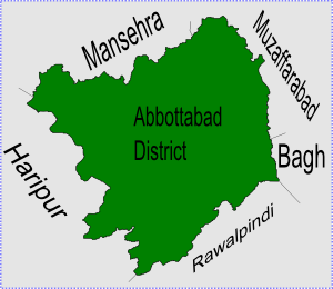
caption = Sherwan is located in Abbottabad District
province =NWFP
district = Abbottabad
tehsil = Abbottabad
nazim = Junaid Ahmed [http://www.abbottabad.gov.pk/Union-council/UCDetailPage.asp?name=Sherwan Sherwan Union Council] ]
naib nazim = Muhammad Kahlid
population = 15,000
coordinates =Sherwan is a Union Council of
Abbottabad District in theNorth-West Frontier Province ofPakistan [ [http://www.abbottabad.sdnpk.org/adminunit.htm Administrative Units of District Abbottabad] ] , it is located 35km west ofAbbottabad .People
The population of Sherwan is over 15,000 [ [http://www.abbottabad.sdnpk.org/list_administrative.htm List of Union Councils and population in Abbottabad District] ] . The local language is
Hindko whileUrdu is also understood and spoken by local peoples. The main ethnic groups or tribes of this area are theTanoli s and the Awans.Location
Sherwan is located in a beautiful valley which is surrounded by large, forested mountains on three sides. These forests host a number of wild animals, such as jackals, wolves, pigs, porcupines and occasionally tigers. Sherwan is divided into two parts Sherwan Khurd (small) and Sherwan Kalan (wide). Sherwan Kalan covers a much larger area than Sherwan Khurd. In the North-East of Sherwan Union Council there is another Place called Patheel.
On the south of the valley there is a stream called Mangal, home to a number of fish such as
Trout , Salmons (Maley), Eels and soles etc.In the East of Sherwan is
Amirabad village , located at the bottom of Koe Bulyana which is around 6000 feet from sea level.Locals grow seasonal crops such as Maize (makai) and Wheat (gandum). By having plenty of water and soil rich with nutrients Sherwan is rich in fruits such as
cherry , orange, apple, plum and apricot.Patheel
Patheel is located in the centre of the Sherwan valley and is also famous by the name of (Tanoli’s Dera) role of this central place in the development of Sherwan is very high. Such as Digital Exchange, Primary Schools, Boys & Girls College, and Roads etc. The past history shows that High School of Sherwan build by the (Head of Patheel) from the support of British Government. Basically (Patheel’s people) have large historical back ground as we found that peoples of (Patheel) were great land lords and they rule all over the area for many years at that time (Head of Patheel) import others peoples for working purpose such as for look after their Pets and their lands. (Head of Patheel) donate those peoples Lands, Houses, and other facilities of living. That is why we found today peoples from different castes at (Sherwan). Jaba is a famous and greenery place in patheel whose soil is famous for stunning crops. One of the famous structure of Jaba Patheel is Daral Uloom which is famous for its basic Islamic teachings.
Education
The literacy rate of Sherwan is high compared to other villages of NWFP, however due to the economic situation, a large number of people from Sherwan have migrated to the cities of
Karachi ,Abbottabad andIslamabad as well as emigrating abroad in search of a better life.One Inter college for boys and one Inter college for girls and many primary and high school for boys and girls are the key factor of high rate in literacy.ubdivisions
The Union Council of Sherwan is subdivided into the following areas: Beri, Kharperh, Thethi Ahmed Khan, Chakar Bain, Chorgran, Juna, Kamila, Kangar Palan, Sherwan Kalan, Sherwan Khurd, Khalabat, Chamhati,
Amirabad (Kumaran), Thorey, Kalar Khaitar, Bamochi, Bhateel and Shaheedabad(Cheera).References
Wikimedia Foundation. 2010.