- Crestwood, Edmonton
-
This article is about an Edmonton, Canada, neighbourhood. For other uses, see Crestwood.
Crestwood is a residential neighbourhood in west Edmonton, Alberta, Canada overlooking the North Saskatchewan River valley and nestled between two ravines.
Contents
Geography
It is bounded on the east by the river valley, on the north by the McKinnon Ravine, on the south by the McKenzie Ravine, and on the west by 149 Street. Residents have good access to hiking trails and bike paths in the McKinnon Ravine and in the larger river valley.
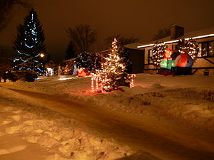 Houses on Candy Cane Lane at Christmas time.
Candy Cane Lane, a popular part of the Christmas celebrations in Edmonton, is located in Crestwood. Residents along Candy Cane Lane decorate their homes with impressive displays of Christmas lights. People drive or walk along the street and enjoy the display.
Demography
Approximately nine out of ten dwellings in the neighbourhood are single family dwellings, with the majority of these being owner occupied. Almost all of the remaining residences are apartments, which are almost all rented. The average household has 2.6 people, with one in four households having four people or more. Most of the houses in Crestwood (72%) were built between the end of World War II and 1960.
There are two schools located in the neighbourhood: Crestwood Elementary Junior High School operated by the Edmonton Public School System and St. Paul Elementary School operated by the Edmonton Catholic School System.
Crestwood is an above average household income neighbourhood.
Income By Household - 2001 Census[1] [2] Income Range ($) Crestwood[3] Edmonton[4] (% of Households) (% of Households) Under $10,000 2.6% 6.3% $10,000-$19,999 9.9% 12.4% $20,000-$29,999 6.3% 11.9% $30,000-$39,999 8.9% 11.8% $40,000-$49,999 5.7% 10.9% $50,000-$59,999 9.4% 9.5% $60,000-$69,999 8.3% 8.3% $70,000-$79,999 6.1% 6.7% $80,000-$89,999 4.7% 5.4% $90,000-$99,999 4.2% 4.2%% $100,000 and over 33.9% 12.6%% Average household income $109,376 $57,360 Community League
The Crestwood Community League (founded on March the 3, 1917[5] and originally known as the "142 Street District Community League") is the believed to be the oldest continuing Community League in Edmonton, Alberta and Canada.
Surrounding Neighbourhoods

Canora Grovernor, Glenora North Saskatchewan River West Jasper Place 
North Saskatchewan River  Crestwood

Sherwood Parkview North Saskatchewan River Notes
- ^ 2000 dollars
- ^ Income is for all persons in the household. So, if there are two persons in the household and each person earns $15,000, the household income is $30,000
- ^ http://censusdocs.edmonton.ca/DD26/FEDERAL%202001/Neighbourhood/CRESTWOOD.pdf
- ^ http://censusdocs.edmonton.ca/DD26/FEDERAL%202001/CITY/EDMONTON.pdf
- ^ p.28 "Edmonton's urban villages" By Ron Kuban
External links
Categories:- Neighbourhoods in Edmonton
- Edmonton Capital Region geography stubs

Wikimedia Foundation. 2010.