- Bitterroot Mountains
-
Bitterroot Mountains Range 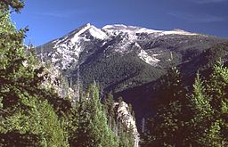 Trapper Peak, in the Central Bitterroot Range
Country United States Regions Montana, Idaho Part of Rocky Mountains Highest point Trapper Peak - elevation 10,157 ft (3,096 m) - coordinates 45°53′23.43″N 114°17′52.11″W / 45.8898417°N 114.2978083°W Area 4,862 sq mi (12,593 km2) - This article is about the Bitterroot Mountains, a subrange of the larger Bitterroot Range.
The Northern and Central Bitterroot Range, collectively the Bitterroot Mountains, is the largest portion of the Bitterroot Range, part of the Rocky Mountains, located in the panhandle of Idaho and westernmost Montana in the Western United States. The mountains encompass an area of 4,862 square miles (12,593 km²).
The mountains are bordered on the north by Lolo Creek, to the northeast by the Clark Fork, on the south by the Salmon River, on the east by the Bitterroot River and Valley, and on the west by the Selway and Lochsa Rivers.[1] Its highest summit is Trapper Peak, at 10,157 feet (3,096 m).
Contents
Northern Bitterroot Range
Northern Bitterroot Range Range Country United States Regions Montana, Idaho Highest point Rhodes Peak - elevation 7,930 ft (2,417 m) - coordinates 46°40′29.26″N 114°47′0.63″W / 46.6747944°N 114.7835083°W Length 66 mi (106 km), N/S Width 88 mi (142 km), E/W Area 1,869 sq mi (4,841 km2) The Northern Bitterroot Range is the northernmost and shortest subrange of the Bitterroot Mountains. The Northern Bitterroots encompass 1,869 square miles (4,841 km²) and its two tallest peaks are the 7,930 foot (2,417 m) Rhodes Peak and the 7,770 foot (2,368 m) Quartz Benchmark.[2]
The Northern Bitterroots also contain a smaller subrange, the Grave Creek Range. The Grave Creek Range is 262 square miles (679 km²) in area and its highest peak is the 7,270 foot (2,216 m) Petty Mountain.[3]
Central Bitterroot Range
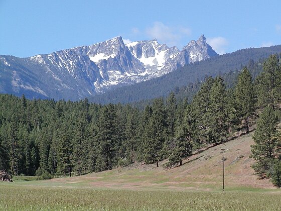
Central Bitterroot Range Range 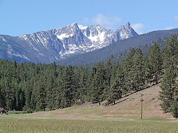 Another view of Trapper Peak, from US 93
Country United States Regions Montana, Idaho Highest point Trapper Peak - elevation 10,157 ft (3,096 m) - coordinates 45°53′23.43″N 114°17′52.11″W / 45.8898417°N 114.2978083°W Length 103 mi (166 km), N/S Width 48 mi (77 km), E/W Area 2,993 sq mi (7,752 km2) The Central Bitterroot Range is the southernmost and tallest subrange of the Bitterroot Mountains. The Central Bitterroots encompass 2,993 square miles (7,752 km²) and its two tallest peaks are the 10,157 foot (3,096 m) Trapper Peak and the 9,983 foot (3,043 m) El Capitan.[4]
The Central Bitterroots also contain a smaller subrange, the Como Peaks. The Como Peaks subrange is 79 square miles (205 km²) in area and its highest peak is the aforementioned El Capitan.
Bitterroot controversy
Swanson (2011) examines the critical role of Guy M. Brandborg of the U.S. Forest Service, who was supervisor of the Bitterroot National Forest from 1935 to 1955. By insisting on selective cutting, his tried to protect the watersheds and wildlife habitats that are harmed by clear-cutting. After he retired in 1955 Brandborg denounced the Forest Service for deviating from his model. He launched a public attack, known as the "Bitterroot controversy." Brandborg lobbied to secure passage of the National Forest Management Act of 1976, that codified his model.
See also
- Bitterroot National Forest
- List of mountain ranges in Montana
Further reading
- Swanson, Frederick H. The Bitterroot and Mr. Brandborg: Clearcutting and the Struggle for Sustainable Forestry in the Northern Rockies (University of Utah Press, 2011). ISBN 978-1-60781-101-5
Notes
- ^ "Bitterroot Mountains". Canadian Mountain Encyclopedia. Bivouac.com. Retrieved 4 March 2007.
- ^ "Northern Bitterroot Range". Peakbagger.com. http://www.peakbagger.com/range.aspx?rid=14312. Retrieved 4 March 2007.
- ^ "Grave Creek Range". Peakbagger.com. http://www.peakbagger.com/range.aspx?rid=143129. Retrieved 4 March 2007.
- ^ "Central Bitterroot Range". Peakbagger.com. http://www.peakbagger.com/range.aspx?rid=14313. Retrieved 4 March 2007.
 State of Montana
Topics - Index
- History
- Governors
- People
- Geography
- State Government
- Delegations
- Visitor Attractions
Society - Crime
- Demographics
- Economy
- Education
- Politics
Regions - The Flathead
- Glacier National Park
- Regional designations of Montana
- Western Montana
- Yellowstone
Largest cities Counties - Beaverhead
- Big Horn
- Blaine
- Broadwater
- Carbon
- Carter
- Cascade
- Chouteau
- Custer
- Daniels
- Dawson
- Deer Lodge
- Fallon
- Fergus
- Flathead
- Gallatin
- Garfield
- Glacier
- Golden Valley
- Granite
- Hill
- Jefferson
- Judith Basin
- Lake
- Lewis and Clark
- Liberty
- Lincoln
- Madison
- McCone
- Meagher
- Mineral
- Missoula
- Musselshell
- Park
- Petroleum
- Phillips
- Pondera
- Powder River
- Powell
- Prairie
- Ravalli
- Richland
- Roosevelt
- Rosebud
- Sanders
- Sheridan
- Silver Bow
- Stillwater
- Sweet Grass
- Teton
- Toole
- Treasure
- Valley
- Wheatland
- Wibaux
- Yellowstone
Categories:- Mountain ranges of Montana
- Bitterroot Range
- Landforms of Ravalli County, Montana
- Landforms of Missoula County, Montana
- Landforms of Mineral County, Montana
- Idaho geography stubs
- Montana geography stubs

Wikimedia Foundation. 2010.