- Manali, Himachal Pradesh
-
For other uses, see Manali (disambiguation).
Manali — city — 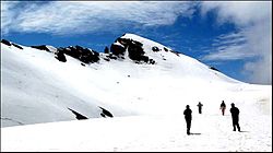
Coordinates 32°16′N 77°10′E / 32.27°N 77.17°ECoordinates: 32°16′N 77°10′E / 32.27°N 77.17°E Country India State Himachal Pradesh District(s) Kullu Population 17,786 (2005[update]) Time zone IST (UTC+05:30) Area
• 1,950 metres (6,400 ft)
Manali (Hindi: मनाली) (alt. 1,950 m or 6,398 ft), in the Beas River valley, is an important hill station in the mountains of Himachal Pradesh, India, near the northern end of the Kullu Valley. It is located about 250 kilometres (155 mi) north of state capital, Shimla.
Manali is administratively a part of the Kullu district, with population of approx. 30,000. The small town was the beginning of an ancient trade route to Ladakh and, from there, over the Karakoram Pass on to Yarkand and Khotan in the Tarim Basin.
Manali and the surrounding area is of great significance to Indian culture and heritage as it is said to be the home of the Saptarshi, or Seven Sages[citation needed].Contents
Geography
Manali is located at 32.239633 N,77.188715 E The town ranges in elevation from 1,800 m (5,900 ft) to, in the uppermost "Old Manali" section, 2,000 m (6,600 ft).
Demographics
Manali is a cosmopolitan town. People from different parts of India have settled here. As of 2001[update] India census,[1] Manali had a population of 6265. Males constitute 64% of the population and females 36%. Manali has an average literacy rate of 74%, higher than the national average of 59.5%: male literacy is 80%, and female literacy is 63%. In Manali, 9% of the population is under 6 years of age.
Climate
The climate in Manali is predominantly cold during winters, and moderately cool during summers. The temperatures range from 4 °C (39 °F) to 30 °C (86 °F) over the year. The average temperature during summer is between 14 °C (57 °F) and 20 °C (68 °F), and between −7 °C (19 °F) and 10 °C (50 °F) in the winter.[citation needed]
Climate data for Manali Month Jan Feb Mar Apr May Jun Jul Aug Sep Oct Nov Dec Year Average high °C (°F) 10.6
(51.1)11.7
(53.1)16.1
(61.0)21.9
(71.4)24.9
(76.8)27.2
(81.0)25.9
(78.6)25.4
(77.7)25.0
(77.0)22.4
(72.3)18.4
(65.1)13.8
(56.8)20.28 Average low °C (°F) −1.7
(28.9)−0.7
(30.7)2.4
(36.3)5.9
(42.6)8.6
(47.5)12.4
(54.3)15.3
(59.5)14.9
(58.8)11.2
(52.2)5.4
(41.7)1.5
(34.7)−0.4
(31.3)5.4 Rainfall mm (inches) 128.9
(5.075)124.3
(4.894)189.6
(7.465)103.7
(4.083)82.5
(3.248)74.3
(2.925)217.5
(8.563)205.4
(8.087)111.9
(4.406)37.9
(1.492)31.7
(1.248)56.1
(2.209)1,363.8
(53.693)Source: IMD (1968-2000) [2]
Monthly precipitation varies between 31 mm (1.2 in) in November to 217 mm (8.5 in) in July. In average, some 45 mm (1.8 in) of precipitation is received during winter and spring months, increasing to some 115 mm (4.5 in) in summer as the monsoon approaches. The average total annual precipitation is 1,363 mm (53.7 in). Snowfall in the region, which usually took place in the month of December, has been delayed over the last fifteen years to January or early February.Etymology
Manali is named after the Brahmin lawgiver Manu. The word Manali is regarded as the changed name of "Manu-Alaya" which literally means "the abode of Manu".[3] Legend has it that sage Manu stepped off his ark in Manali to recreate human life after a great flood had deluged the world. Manali is also often referred to as the "Valley of the Gods".[4] The Old Manali village has an ancient temple dedicated to sage Manu.[5][6]
History
In ancient times, the valley was sparsely populated by nomadic hunters known as 'rakshas'. The next arrivals were the shepherds who arrived from the Kangra Valley and settled to take up agriculture. Some of the earliest inhabitants of the region are the 'naur' or 'nar', which is a caste unique to the Kullu valley. Only a few naur families are known to exist now. A naur family in the village Soyal near Haripur on the west bank of Manali was famous for the vast land they owned and their practice of having 'rakshas' as their labourers.[citation needed]
The British introduced apple trees and trout, which were not native to Manali flora and fauna. It is said that when apple trees were first planted the fruits were so plentiful that often branches, unable to bear the weight, would collapse.[citation needed] To this day, apple—along with plum and pear—remains the best source of income for the majority of its inhabitants.
Tourism in Manali received a boost after the rise of militancy in Kashmir in the late 1980s. This once quiet village was transformed into a bustling town with many hotels and restaurants.
Transport
Manali is well connected by road to Delhi through NH-21 and NH 1, which goes on to Leh and is claimed to be world's highest motorable road. Leading up to Manali from New Delhi are the towns of Panipat and Ambala in Haryana, Chandigarh(Union Territory), Ropar in Punjab, and Bilaspur, Sundernagar, and Mandi in Himachal.
Manali is not easily approachable by rail. The nearest broad gauge railheads are at Chandigarh (315 km (196 mi)), Pathankot (325 km (202 mi)) and Kalka (310 km (190 mi)). The nearest narrow gauge railhead is at Joginder Nagar (135 kilometres (84 mi))
The nearest airport is at Bhuntar, which is about 50 km (31 mi) from Manali. Currently, Kingfisher Red operates daily nonstop services from Delhi, Air India provides twice a week nonstop services and MDLR Airlines provides services to Delhi six days in a week.
Places of interest
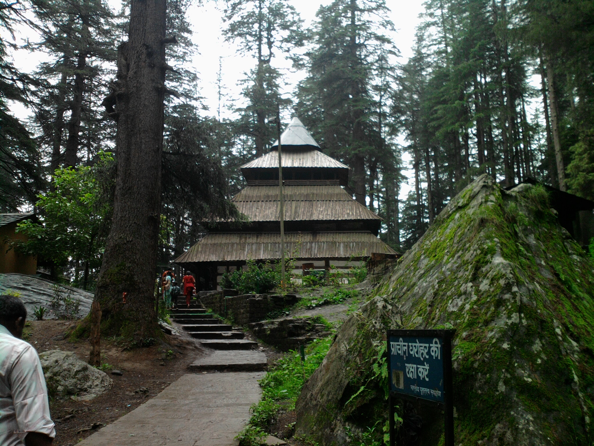
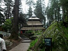 Hadimba Temple, Manali.
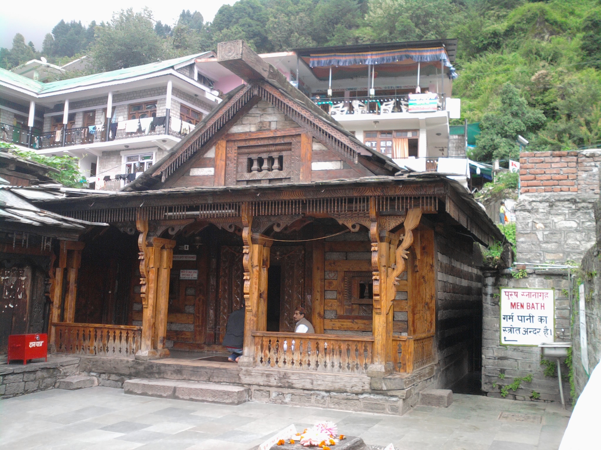
 Vashisht Temple, Manali.
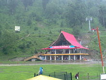 Rope way cum ski centre, Solang valley
HADIMBA TEMPLE (1 km) : Built in 1533 A.D. with a superbly crafted four tiered pagoda roof, it is famous for its exquisitely carved doorway.
MANU TEMPLE (2 km) : This is dedicated to the sage Manu situated at old Manali.
VASHISTH (3 km) : Well known for its hot springs. There are old temples dedicated to the sage Vashisth and to Lord Rama.
MONASTERIES : There are three recently built Tibetan monasteries at Manali.
JAGATSUKH (6 km) : The one time capital of Kullu. Here are old temples dedicated to Lord Shiva and to Sandhya Gayatri. The Arjun caves are just ahead.
SOLANG VALLEY(14 km) : In a picturesque setting this has good ski slopes and picnic spots.
TOWARDS THE ROHTANG PASS : On the road to Keylong is the Nehru Kund (6km) which is a clear water spring scenic spot named after the Late Pt. Jawaharlal Nehru. Kothi (12km) is a picturesque village and has a thrilling view of the deep gorge through which the Beas swiftly races. The beautiful Rahalla falls (16km) are at at altitude of 2500m. A crucial link on the old trade route and still the gateway to trans Himalayan Lahaul, the Rohtang Pass is at height of 3978 m.
CLUB HOUSE : The Club House with its comprehensive facilities that include a roller skating rink, an auditorium, billiards rooms, a library, a bar and restaurant makes wonderful outing for the day.Bungee jumping is also provided.
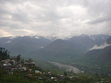 Beas river flowing from the mountains
CAFE JUNIPAR : Himachal Tourism also runs the Juniper cafe and Chandratal restaurants at Manali.
Nagar : This is also very beautiful place in manali.
ROHTANG : This is beautiful Snow covered area near by manali, Just 52 Km. from manali.
http://www.filmapia.com/published/places/rohtang-pass
Further reading
- Verma, V. 1996. Gaddis of Dhauladhar: A Transhumant Tribe of the Himalayas. Indus Publishing Co., New Delhi.
- Handa, O. C. 1987. Buddhist Monasteries in Himachel Pradesh. Indus Publishing Co., New Delhi. ISBN 81-85182-03-5.
References
- ^ "Census of India 2001: Data from the 2001 Census, including cities, villages and towns (Provisional)". Census Commission of India. Archived from the original on 2004-06-16. http://web.archive.org/web/20040616075334/http://www.censusindia.net/results/town.php?stad=A&state5=999. Retrieved 2008-11-01.
- ^ "Indian Meteorological Department - Govt Of India". Indian Meteorological Department. http://www.imd.gov.in/doc/climateimp.pdf. Retrieved 2011-08-22.
- ^ Adventuretrips - Kullu, Himachal Pradesh
- ^ Manali Hotels - Manuallaya Resorts
- ^ http://www.bharatonline.com/himachal-pradesh/travel/manali/manu-temple.html
- ^ http://www.mapsofindia.com/manali/travel/manu-temple.html
External links
Leh-Manali Highway Passes Valleys Towns Rivers Kullu Manali Circuit Sutlej Trail Beas Trail Kullu Valley Trail Across The Rohtang Pass Categories:- Tourism in Himachal Pradesh
- Hill stations in India
- Ski areas and resorts in India
- Cities and towns in Kullu district


Wikimedia Foundation. 2010.