- Monash Freeway
-
Monash Freeway 
Formerly  _
__  _
_

Length 34 km (21 mi) Direction Northwest-Southeast From  CityLink,
Kooyong, Melbournevia Chadstone, Mulgrave, Doveton, Narre Warren To Princes Freeway, Berwick, MelbourneEstablished 1973 Major junctions  Toorak Road
 Warrigal Road
 Springvale Road
 EastLink
 Stud Road
 South Gippsland Freeway

 Princes Highway
for full list see exits and interchanges
Monash Freeway is an urban freeway in Victoria, Australia linking Melbourne's CBD to its southeastern suburbs and the Gippsland region. The entire stretch of the Monash Freeway bears the designation
 . The freeway was originally shown in the 1969 Melbourne Transportation Plan as part of the F9 and F14 Freeway corridors.
Contents
History
The Monash Freeway is an amalgamation of two initially separate freeways: the Mulgrave Freeway (initially designated
) linking Warrigal Road, Chadstone to the Princes Highway in Eumemmerring; and the South Eastern Freeway (initially designated ) linking Punt Road, Richmond and Toorak Road, Hawthorn East.Mulgrave Freeway
Initial construction on the Mulgrave Freeway started in 1970 and was completed in 1973, with bi-directional interchanges with Heatherton and Stud Roads. Later in the 1970s and in the early 1980s it was progressively extended westward to Forster Road - with additional interchanges at Blackburn, Ferntree Gully, Wellington and Jacksons Roads (and eventually Police Road during the early to mid 90's) - then to Huntingdale Road, and finally to Warrigal Road in Chadstone. Construction at the Hallam end extended underneath an interchange at the Princes Highway and southwards along the old alignment of the South Gippsland Highway to the interchange with Dandenong-Hastings Road, now the Westernport Highway at Lyndhurst; this section was initially named the Eumemmerring Freeway, but later named the South Gippsland Freeway. The
designation was dropped in 1988, coinciding with the opening of the South Eastern Arterial.Interestingly at this time the Tullamarine Freeway also carried the
route shield. This was due to the 1969 Melbourne Transportation Plan having the two freeways linked to each other from around East Malvern (at the Mulgrave Freeway end) and at Flemington (at the Tullamarine Freeway end), sweeping through the St Kilda area. The plan never came to fruition, but the two freeways have since been linked by the West Gate Freeway extension and the CityLink project.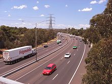 Monash Freeway (former South Eastern Arterial) viewed from the footbridge at East Malvern Station
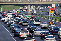 Traffic slowed to a crawl on the Monash Freeway in peak hour traffic
South Eastern Freeway
Initial construction of the South Eastern Freeway had completed by the mid-1960s, connecting Burnley to Olympic Park at Harcourt Parade, which fed traffic to Punt Road at the Hoddle Bridge: an overpass across Punt Road quickly followed to end at Anderson Street and the Morell Bridge, with a single-carriageway feeder road to the Swan Street Bridge (and Batman Avenue) 800 metres beyond. The freeway was eventually further extended east from Burnley under the MacRobertson Bridge along the Yarra, to Toorak Road (with a single-carriageway feeder road taking excess traffic to Tooronga Road. Part of the road still exists along the Home Hardware store which can be seen from the Tooronga road overpass of the Monash Fwy. This was completed in 1971. Initially designated
 in the 1960s, it was later signed as until 1988, when the South Eastern Arterial was completed.
South Eastern arterial link
The resulting gap between the Toorak / Burke Road end of the South Eastern Freeway and the Warrigal Road end of the Mulgrave Freeway frustrated drivers for many years, needing to rely increasingly on feeder roads to bridge the distance between them. The State Government proposed a road to connect them during the mid-1980s, before finally agreeing on an alignment and allowing construction to commence on a dual-carriageway link between the freeways; construction finished in 1988, and the link - and later the entire length of the now-connected freeway, from the city to Eumemmerring - was re-christened as the South Eastern Arterial; the new stretch of road also re-designated
 , with the Princes Highway (Dandenong Road) becoming an alternative route.
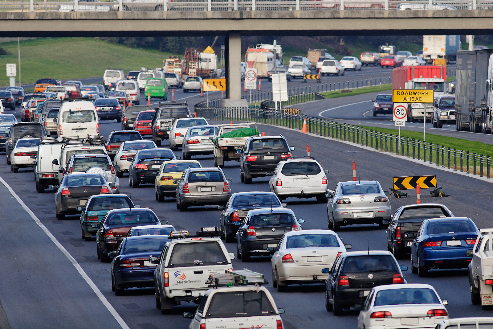
The project attracted a great deal of controversy just before it opened and well afterwards: in order to save costs, only one freeway-style interchange had been constructed (underneath High Street in Glen Iris). Every other interchange with major roads along the route (Toorak, Burke, Tooronga and Warrigal Roads) was an at-grade intersection controlled by traffic-lights, and because the road was constructed through residential areas, reduced speed limits were also enforced. This led to heavy congestion, frequently kilometres long, on the freeway, fuelling anger and frustration, and even attracting a rather-apt moniker of "the South-Eastern Carpark".
With a change of government several years later and a lot of political showmanship, more money was poured into the link road, constructing underpass interchanges at Toorak and Burke Roads (and just an underpass at Tooronga Road), and a new overpass across Warrigal Road. New noise barriers and extra lanes were also constructed, and the freeway 'upgrade' was completed and the entire length renamed back to the South Eastern Freeway, before changing name again to the now-current Monash Freeway, so named by Premier Kennett after General Sir John Monash, arguably Australia's greatest soldier, engineer, scholar and nation builder. The improved road dramatically improved the rate of out-bound traffic, however the bottleneck at the Swan Street Bridge still remained and the queues only got longer. A portion of the Monash Freeway at the city end (from Toorak to Punt Roads) was eventually incorporated into the CityLink project in the late 1990s by way of tunnels underneath the city to link to the eastern-end of the West Gate Freeway, allowing for an uninterrupted voyage past the CBD.
Hallam bypass
Before this bypass was constructed, the sweeping curve of the freeway at the Hallam end that became the South Gippsland Freeway had its capacity reduced from three lanes to two, resulting in a notorious bottle-neck at peak hours, especially for out-bound traffic exiting at the Princes Highway interchange outside Dandenong; the extension finally bypassed the entire problem.
The freeway was extended by 7.5 km in late 2003 when the Hallam Bypass was completed after 3 years of construction, connecting the Monash Freeway in Hallam to the Princes Freeway in Berwick. It opened 6 months ahead of schedule and A$80 million under budget due to the omission of one key interchange that should have linked the South Gippsland Freeway with the Hallam Bypass at Eummemmering. This omission causes unnecessary congestion on neighbouring roads as northbound South Gippsland Freeway traffic must exit the freeway at Princes Highway only to join the same freeway again from Belgrave-Hallam Road eastbound.
The Monash Freeway allows travel from Morwell in the central Latrobe Valley, to Waurn Ponds in the south-east of Geelong - via CityLink, the West Gate, the Geelong Ring Road and Princes Freeways. Motorists can cover over 200 km without encountering a set of traffic lights (except at Yarragon and Trafalgar, which are yet to be bypassed). The construction of the bypass also included the Hallam Bypass Trail shared path.
Major upgrade
In 2007, the State Government announced a major upgrade widening the lanes from Glenferrie Road through to Heatherton Road. Prior to this, over 160,000 vehicles per day used this freeway resulting in congestion during peak hours. The upgrade started in late 2007 and was expected to be completed in late 2009. The entire project is known as the Monash-CityLink-West Gate upgrade, and is being carried out by VicRoads and Transurban.[1]
Route and conditions
The freeway officially begins at the southern end of CityLink, at Toorak Road. Here the freeway is four lanes wide. The opposing carriageways of the freeway are relatively near to each other and are separated by a concrete barrier. This section has overhead lighting. This first section of freeway runs through the south-eastern suburbs of Malvern, Glen Iris and Malvern East.
After Warrigal Road, the freeway is built within a much wider road reserve, allowing for a wide grass centre median with steel barrier separating the carriageways. This section does not have overhead lighting and carries four lanes on each carriageway. This section runs through south-eastern metropolitan Melbourne, including the suburbs of Chadstone, Mount Waverley, Mulgrave, Dandenong, Hallam, and finally, Narre Warren, where it becomes the Princes Freeway. The final section, the Hallam Bypass, is the newest stretch of the Monash Freeway, and has two lanes in each carriageway.
Exits and interchanges
Monash Freeway 
Northbound exits Exit Number
Distance to MelbourneSouthbound exits End Monash Freeway
continues as CityLink
to Melbourne
--
(9km)Start Monash Freeway
from CityLinkToorak, Burwood
Toorak Road
E4
(9km)Caulfield, Camberwell
Burke Road
E5
(11km)Camberwell, Caulfield
Burke Roadno exit E6
(12km)Glen Waverley, Glen Iris
High Street
GLEN WAVERLEY RAIL LINE --
(16km)GLEN WAVERLEY RAIL LINE Oakleigh, Chadstone
Warrigal Road
E7
(17km)Chadstone, Oakleigh
Warrigal RoadHuntingdale, Burwood
Huntingdale Road
8
(18km)no exit Clayton, Mount Waverley
Forster Road9
(20km)Mount Waverley, Clayton
Forster RoadEdithvale, Blackburn
Blackburn Road
10
(21km)Blackburn, Edithvale
Blackburn Roadno exit 11
(22km)Ferntree Gully, Mount Dandenong
Ferntree Gully Road
Springvale, Glen Waverley
Springvale Road
12
(23km)no exit Oakleigh, Ormond
Wellington Road
13
(25km)Rowville, Emerald
Wellington Roadno exit 14
(27km)Mulgrave, Noble Park
Jacksons RoadSpringvale, Dandenong North
Police Road
15
(28km)no exit TOM WILLS INTERCHANGE
Ringwood
EastLink
16
(29km)TOM WILLS INTERCHANGE
Ringwood, Frankston
EastLinkDandenong, Rowville
Stud Road
17
(31km)Rowville, Dandenong
Stud RoadDandenong North, Endeavour Hills
Heatherton Road
18
(33km)Endeavour Hills, Dandenong North
Heatherton RoadCranbourne, Hastings
South Gippsland Freeway
19
(36km)Cranbourne, Hastings
South Gippsland FreewayHallam, Endeavour Hills
Belgrave-Hallam Road20
(38km)Endeavour Hills, Hallam
Belgrave-Hallam Roadno exit 21
(39km)Ernst Wanke Road Cranbourne, Belgrave
Narre Warren North Road
22
(42km)Belgrave, Cranbourne
Narre Warren North RoadStart Monash Freeway
continues from Princes Freeway East23
(44km)Berwick, Dandenong
Princes Highway

--
(44km)End Monash Freeway
continues as Princes Freeway East
to Warragul / TraralgonSee also
References
Categories:- 1973 establishments in Australia
- Highways and freeways in Melbourne

Wikimedia Foundation. 2010.