- Minas Basin
-
The Minas Basin is an inlet of the Bay of Fundy and a sub-basin of the Fundy Basin located in Nova Scotia, Canada. It is known for its extremely high tides.
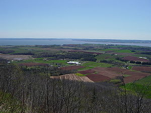 A view of the Southern Bight of the Minas Basin from The Lookoff.
Contents
Geography
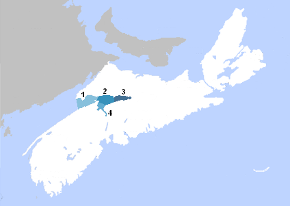
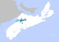 Map showing: (1) Minas Channel, (2) Central Minas Basin, (3) Cobequid Bay, (4) Southern Bight
Boundary
The Minas Basin forms the eastern part of the Bay of Fundy which splits at Cape Chignecto and is delineated by the massive headland of Cape Split. The Minas Basin is split into four sections: Cobequid Bay, from the mouth of the Salmon River to a narrow point between Economy and the Noel Shore; Central Minas Basin, from the mouth of Cobequid Bay to the narrow point between Parrsboro and Cape Blomidon; the Southern Bight, from the mouth of the Avon River to the narrow point between Cape Blomidon and the Noel Shore; and the Minas Channel, from Central Minas Basin to the narrow line between Cape Chignecto and the Annapolis Valley Shore.[1]
Several important rivers in Nova Scotia drain into the Minas Basin: Shubenacadie River, Cornwallis River, Avon River, and the Salmon River. Lesser rivers include the Diligent River, Farrell River, and Debert River.
Along the northern edge of the Minas Basin lies a chain of intermittent high-cliffed basaltic bluffs and islands called the Basalt Headlands.
Tides
Burntcoat Head, located on the "Noel Shore" along the south side of the Minas Basin, is the location of the highest tidal range ever recorded on the planet[citation needed] (during a spring tide only) and has one of the highest average tidal ranges every day. The waters of Minas Bay exchange with the main part of the Bay of Fundy through the Minas Channel which flows between Cape Split and Cape Sharp, creating extremely strong tidal currents. The water in the Minas Basin is brown due to large amounts of suspended silt. At mid-tide, the water passing through the Minas Channel equals the combined flow of all the rivers and streams on Earth together.
Communities
Several communities border the Minas Basin or the rivers that flow into it. They include Truro, Windsor, Parrsboro, Great Village, Bass River, Five Islands, Economy, Wolfville, Walton, and Kingsport. Historically, Parrsboro, Wolfville, and Kingsport were connected by the MV Kipawo ferry,[2] whose name was derived from the three communities.
Parks
Provincial parks [3] at Anthony (near Truro), Five Islands, and Cape Blomidon allow visitors to enjoy and explore the Minas Basin. Community parks interpreting the Basin include the Kingsport waterfront in Kings County; the Walton Lighthouse and Burntcoat Head Lighthouse in Hants County and the Lookout Tower in Economy and the Ottawa House Museum in Parrsboro in Cumberland County.
History
Settlement
The Mi'kmaq were the first people to inhabit the area around the Minas Basin. Mi'kmaq tradition ties the god Glooscap in with significant geographical features such as Cape Blomidon and Five Islands.
After being discovered by the Europeans, the area was settled by the French and British. The French, which late became the Acadians, had a particularly significant impact of the area in that they reclaimed considerable farmland through the use of dykes and aboiteaux. They founded in the area Grand Pré, Les Mines, Pisiguit, Cobequid, Rivière-aux-Canards, and Beaubassin. Even today, their dyke systems are still used near Truro and Wolfville at Port Williams and Grand Pré. In 1755, the British forcibly expelled the over 12,000 Acadians from Grand Pré, Pisiguit, Cobequid, and Beaubassin, in what became known as the Grand Dérangement, or Great Expulsion.
Industry
The communities around the Minas Basin were sustained by fishing, logging, farming, mining, boat building and shipbuilding. In the late 19th Century the Basin's shipyards produced some of the highest numbers of wooden ships in Canadian history and some of the largest, including the ship William D. Lawrence, the largest wooden ship built in Canada along with the giant barques Kings County, Canada's largest four masted-barque and Hamburg, Canada's largest three-masted barque.[4] The water also provided a means of transporting commodities and there was a tide mill at Walton.[5]
Mining included gypsum (several locations including Windsor and Cheverie), iron (Londonderry), barite (near Walton and the Eureka Mine at Five Islands), manganese (several locations including Cheverie and Tennycape), and copper (the Colonial Copper Company at Cap D'Or). Today, gypsum is still shipped from Hantsport.
Nature
Marine mammals include seals and porpoises. Fish include bass, and flounder; lobster, crab, mussel, and clam are common. Many types of seaweed, sponges, worms, seajellys and more are also found. Birds include sandpipers, terns (visitors only), eagles, falcons, seagulls, herons, and kingfishers.
Fossils are found near Parrsboro, Blue Beach and other areas along the Avon River.[6] Rarely, fossils have been found at Evangeline Beach, Burntcoat Head, and other locations. These fossils include various shells (brachiopods, molluscs), sponges, trees, fish, amphibians, reptiles, and dinosaurs. Trace fossils include vertebrate footprints, fish fin-tracks, invertebrate trackways (ex. scorpions at Blue Beach), raindrop inprints, and wave ripples. They range from the beginning of the Carboniferous to the Jurassic. They were deposited when the region was warm and tropical, later when it was covered by a shallow sea, and later still when it was a desert.
Minerals include a variety zeolites from the basalt cliffs at Cape Split, the area around Parrsboro, Five Islands and Cap D'Or. These include Nova Scotia's provincial mineral stilbite, as well as heulandite, analcime, chabazite, gmelinite, natrolite and thomsonite. Other minerals found in the basalts include calcite, magnetite, copper, and quartz (often as amethyst). Beautiful agate is also found. In the sedimentary rocks, gypsum is commonly found at Blomidon, Clarke Head, and near Windsor in both the colorless variety (selenite) and the fibrous variety (satin spar), the latter sometimes being bright orange. Other minerals from the sedimentary rocks include pyrite, calcite, barite, manganite, and pyrolusite. Small amounts of fluorite, celestite, howlite have also been found at Cheverie.
References
- ^ "Minas Basin". http://www.bofep.org/minas1.htm. Retrieved 2007-11-23.
- ^ Belle Island Net Kipawo Page
- ^ Nova Scotia Parks (Provincial website)
- ^ Sailing Ships of the Maritimes: An Illustrated History Of Shipping And Shipbuilding In The Maritime Provinces of Canada 1750-1925, Charles Armour and Thomas Lackey (Toronto: McGraw-Hill Ryerson, 1975), p. 168, 180
- ^ Natural History of Nova Scotia, Theme Regions, "620-Tidal Bay: Cultural Landscapes", 1996
- ^ The Last Billion Years, A Geological History of the Maritime Provinces of Canada, Atlantic Geoscience Society, Nimbus Publishing, 2001
External links
Categories:- Bays of Nova Scotia
- Landforms of Nova Scotia
- Cumberland County, Nova Scotia
- Colchester County, Nova Scotia
- Hants County, Nova Scotia
- Kings County, Nova Scotia
- Fossil trackways

Wikimedia Foundation. 2010.