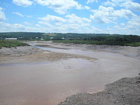
- Cornwallis River
-
Cornwallis River Origin Caribou Bog Mouth Minas Basin Basin countries Canada Length 48 km Mouth elevation sea level The Cornwallis River is a river in Nova Scotia, Canada.
It has a meander length of approximately 48 km[1] from its source on the North Mountain near Berwick to its mouth near Wolfville on the Minas Basin. The lower portion of the river is tidal and there are extensive tidal marshes in the lower reaches. While the river is no longer used for navigation, Port Williams was once an important destination for coastal shipping. The Cornwallis Valley Railway, a branchline of the Dominion Atlantic Railway, was named after the river in 1889 when it was built crossing the river at Kentville.
Called the Grand Habitant river by its original settlers, the Acadians,[2] it was renamed following the Expulsion to honour the memory of Edward Cornwallis, the founder of Halifax and governor of Nova Scotia from 1749 to 1752. The river flows through central Kings County. It is unusual in that the valley it lies within is named for a different river. The Annapolis Valley is named for the larger Annapolis River which flows westwards from the same headwaters.
The Annapolis Valley is an important agricultural district in Nova Scotia and depends on the river of irrigation and drainage. However heavy agricultural runoffs as well as municipal sewage have created severe pollution problems in the river. It was designated as one of Canada ten most endangered rivers in 2002 and labelled as "little more than a farm sewer".[3] A number of initiatives are currently underway to improve farm use of the river and upgrade municipal sewage systems along the river.[4] The communities of Wolfville, Port Williams, Kentville and Berwick all have sewage treatment facilities that discharge effluent into the river.
Communities
- Kentville
- Port Williams
- Berwick
- Grand Pre
- Wolfville
- Cornwallis Square
References
- ^ Columbia Gazeteer
- ^ Town Plot - Starrs Point
- ^ "Group Names Most Endangered Rivers" CBC Radio News June 18, 2002
- ^ Sara Keddy, "Cornwallis headwaters watershed group looking out for Upper Cornwallis improvements ", Kings County Register, June 24, 2008.
External links
- Natural History of Nova Scotia
- Christian Perry-Giraud, Thirty Year Assessment of the Cornwallis Estuary Evolution, Bay of Fundy Ecosystem Partnership, 2005.
Coordinates: 45°6′5″N 64°21′54.7″W / 45.10139°N 64.365194°W
Categories:- Rivers of Nova Scotia
- Kings County, Nova Scotia
Wikimedia Foundation. 2010.


