- Doubrava
-
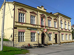
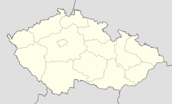
Doubrava — Village — Národní dům (National House) Location in the Czech Republic Coordinates: 49°51′33″N 18°28′11″E / 49.85917°N 18.46972°E Country Czech Republic Region Moravian-Silesian District Karviná First mentioned 1229 Government – Mayor Květuše Szyroká Area – Total 7.77 km2 (3 sq mi) Elevation 235 m (771 ft) Population (2006) – Total 1,507 – Density 194/km2 (502.3/sq mi) Postal code 735 33 Website Doubrava website  Doubrava (help·info) (1920-1924: Dombrová)[1] (Polish: Dąbrowa , German: Dombrau) is a village in Karviná District, Moravian-Silesian Region, Czech Republic. It has a population of 1,507 (2006) and lies in the historical region of Cieszyn Silesia.
The name of the village comes from the Slavic for "oak" (Polish: dąb, Czech: dub) and means "oak forest".
Contents
History
It is not clear when the village was founded. It first appears in a written document in 1229. During the Middle Ages the village changed hands often. From 1746 to 1901 it belonged to the Mattencloit family, who in 1901 sold it to a member of the Viennese banking family the Rothschilds.
An important milestone in the history of the village was the discovery of coal in 1822. The digging of small coal mines began, most of which were later abandoned. In 1854–1855 two mines were dug, christened Eleonora and Bettina. The majority of the local population worked in the coal mining industry. The local coal mines were later consolidated into a joint venture, Důl Doubrava (Doubrava Coal Mine). Tower of Bettina coal mine was detonated on 23 October 2006, tower of Eleonora coal mine was detonated on 2 November 2007.
After the division of Cieszyn Silesia in 1920, the village became part of Czechoslovakia as Dombrová. Following the Munich Agreement, in October 1938, Doubrava and the whole Zaolzie region were annexed by Poland. The village was then annexed by Nazi Germany at the beginning of World War II. After the war it was restored to Czechoslovakia.
In 1974 Doubrava was administratively joined to the town of Orlová. Living conditions in Doubrava deteriorated during the Communist era as a result of extensive coal mining. In 1990 it once again became an independent municipality.
The most important landmarks in the village are the Roman Catholic church devoted to Saint Hedvika, consecrated in 1899, the 1928 Czechoslovak Hussite church, and Národní dům (National House), built in 1903 to serve cultural and sporting purposes.
Gallery
People
- Jan Buzek, Polish physician and politician, worked in the village.
- Józef Kiedroń, Polish engineer and politician, worked in the village.
See also
Footnotes
- ^ Hosák et al. 1970, 190-191.
References
- Chlup, Danuta (2007-09-27). "Wioska powraca do życia". Głos Ludu: p. 1.
- Hosák, Ladislav; and Rudolf Šrámek (1970). Místní jména na Moravě a ve Slezsku I, A-L. Praha: Academia.
- "Na Doubravě padne druhá těžní věž". OKD. 2007-11-01. http://www.okd.cz/cz/media/tiskove-zpravy/na-doubrave-padne-druha-tezni-vez/?jehled=1.
External links
 Media related to Doubrava at Wikimedia Commons
- (Czech) Official website
Towns and villages of Karviná District Albrechtice · Bohumín · Český Těšín · Dětmarovice · Dolní Lutyně · Doubrava · Havířov · Horní Bludovice · Horní Suchá · Chotěbuz · Karviná · Orlová · Petrovice u Karviné · Petřvald · Rychvald · Stonava · Těrlicko
Coordinates: 49°51′33″N 18°28′11″E / 49.85917°N 18.46972°ECategories:- Populated places in Karviná District
- Cieszyn Silesia
- Villages in the Czech Republic
- Karviná District
Wikimedia Foundation. 2010.


