- Chotěbuz
-
Chotěbuz
Kocobędz— Village — Archeopark Podobora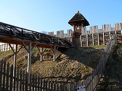
Flag
Coat of armsLocation in the Czech Republic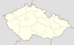

Coordinates: 49°46′10″N 18°35′10″E / 49.76944°N 18.58611°E Country Czech Republic Region Moravian-Silesian District Karviná First mentioned 1229 Government – Mayor Martin Pinkas Area – Total 10.61 km2 (4.1 sq mi) Elevation 330 m (1,083 ft) Population (2006) – Total 1,088 – Density 102.5/km2 (265.6/sq mi) Postal code 735 61 Website http://www.chotebuz.cz/  Chotěbuz (help·info) (Polish: Kocobędz , German: Kotzobendz) is a village in Karviná District, Moravian-Silesian Region of the Czech Republic. It lies on the border with Poland, on the left bank of the Olza River, in the historical region of Cieszyn Silesia. It has 1,033 inhabitants (2001 census), 21.3% of the population are the Poles.[1]
Contents
History
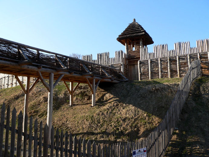
The village is one of the oldest in Cieszyn Silesia, it was mentioned for the first time in a written document in 1229 as Koczobontz.[2] It was then a property of Benedictine monastery in Orłowa. However, there was a fortified settlement (gród) in this place called Cieszynisko (or Old Cieszyn). It was an important center since the 8th century. After decline of the settlement at the beginning of the 12th century, it was relocated to Wzgórze Zamkowe (castle hill) in Cieszyn. Near the old place a new settlement was created, Podobora. It is today an archaeological site and was partly rebuilt to form archeopark which is possible to visit.
Remains of an old Gothic fort from the 13th century still remain, in its vicinity a Renaissance fort was later built. It was eventually rebuilt into a château at the beginning of the 19th century by the new owner. The Château gained its current look in 1875-1879, when it was completely rebuilt. It was again renovated in 1947.
From 1974 to 1997 Chotěbuz was administratively a part of Český Těšín.
There is a border crossing with Poland in the village, one of the largest in the country and the largest between the Czech Republic and Poland. It is connected with the Polish one by the long bridge built in 1991 running along the Olza River.
Footnotes
- ^ "2001 census data". Czech Statistical Office. http://www.czso.cz/sldb/sldb2001.nsf/obce/555291?OpenDocument.
- ^ Hosák et al. 1970, 323.
References
- Cicha, Irena; Kazimierz Jaworski, Bronisław Ondraszek, Barbara Stalmach and Jan Stalmach (2000). Olza od pramene po ujście. Český Těšín: Region Silesia. ISBN 80-238-6081-X.
- Hosák, Ladislav; and Rudolf Šrámek (1970). Místní jména na Moravě a ve Slezsku I, A-L. Praha: Academia.
External links
- (Czech) Official website
Towns and villages in Zaolzie with significant Polish population* Albrechtice (Olbrachcice) · Bocanovice (Boconowice) · Bukovec (Bukowiec) · Bystřice (Bystrzyca) · Český Těšín (Czeski Cieszyn) · Chotěbuz (Kocobędz) · Dolní Lomná (Łomna Dolna) · Hnojník (Gnojnik) · Horní Lomná (Łomna Górna) · Horní Suchá (Sucha Górna) · Hrádek (Gródek) · Jablunkov (Jabłonków) · Karviná (Karwina)** · Komorní Lhotka (Ligotka Kameralna) · Košařiska (Koszarzyska) · Milíkov (Milików) · Mosty u Jablunkova (Mosty koło Jabłonkowa) · Návsí (Nawsie) · Nýdek (Nydek) · Písečná (Pioseczna) · Písek (Piosek) · Petrovice u Karviné (Piotrowice koło Karwiny) · Řeka (Rzeka) · Ropice (Ropica) · Smilovice (Śmiłowice) · Stonava (Stonawa) · Střítež (Trzycież) · Těrlicko (Cierlicko) · Třanovice (Trzanowice) · Třinec (Trzyniec) · Vělopolí (Wielopole) · Vendryně (Wędrynia)
* More than 10% of total population; 2001 census data. **Karviná fell under 10% in the 2001 census.
Villages with significant Polish population under the administration of another municipality are not listed.Towns and villages of Karviná District Albrechtice · Bohumín · Český Těšín · Dětmarovice · Dolní Lutyně · Doubrava · Havířov · Horní Bludovice · Horní Suchá · Chotěbuz · Karviná · Orlová · Petrovice u Karviné · Petřvald · Rychvald · Stonava · Těrlicko
Coordinates: 49°46′10″N 18°35′10″E / 49.76944°N 18.58611°E
This Moravian-Silesian Region location article is a stub. You can help Wikipedia by expanding it.