Cisownica

Cisownica
Cisownica
—  Village  —
Village's centre
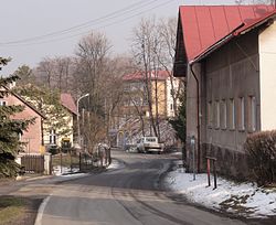
Cisownica is located in Poland
Cisownica
Coordinates: 49°43′15.45″N 18°45′46.17″E / 49.7209583°N 18.762825°E / 49.7209583; 18.762825
Country Poland
Voivodeship Silesian
County Cieszyn
Gmina Goleszów
First mentioned 1305
Government
 - Mayor Władysław Sikora
Area 9.5967 km2 (3.7 sq mi)
Population (2008) 1,705
 - Density 177.7/km2 (460.2/sq mi)
Time zone CET (UTC+1)
 - Summer (DST) CEST (UTC+2)
Postal code 43-440
Car plates SCI

Cisownica is a village in Gmina Goleszów, Cieszyn County, Silesian Voivodeship, southern Poland, close to the border with the Czech Republic. In 2008 it had a population of 1,705. It lies in the historical region of Cieszyn Silesia on the slopes of Mała Czantoria mountain.

It was first mentioned in a written document in 1305. The name of the village is derived from the taxus trees ("cis" in Polish) which grew here in the past in large numbers.

In the 18th and 19th centuries siderite was mined here., the last mine closed in 1870.

In 1981, and Evangelical-Augsburg Church was built in the village. Cisownica in recent years has become a popular tourist destination, due to its vicinity to the Silesian Beskids mountain range.

People

  • Jura Gajdzica, peasant writer, lived here
  • Jan Sztwiertnia, member of Sejm, was born here

External links


Wikimedia Foundation. 2010.

Игры ⚽ Нужно решить контрольную?

Look at other dictionaries:

  • Cisownica — Original name in latin Cisownica Name in other language Cisownica State code PL Continent/City Europe/Warsaw longitude 49.72276 latitude 18.76207 altitude 380 Population 1705 Date 2010 09 06 …   Cities with a population over 1000 database

  • Cieszyn — For other places with the same name, see Cieszyn (disambiguation). Cieszyn Town square …   Wikipedia

  • Český Těšín — Czeski Cieszyn   Town   Town hall of Český Těšín …   Wikipedia

  • Czechowice-Dziedzice — Church of Jesus Christ the Redeemer …   Wikipedia

  • Ostrava — Coordinates: 49°50′08″N 18°17′33″E / 49.83556°N 18.2925°E / 49.83556; 18.2925 …   Wikipedia

  • Cieszyn Silesia — Těšínsko redirects here. For other uses, see Těšínsko (disambiguation). Polish map of Cieszyn Silesia. The solid black line is the historical border of the region, and the broken black line is the international border …   Wikipedia

  • Duchy of Teschen — Księstwo Cieszyńskie (pl) Těšínské knížectví (cs) Herzogtum Teschen (de) Ducatus Tessinensis (la) Silesian duchy Fiefdom of the Kingdom of Bohemia …   Wikipedia

  • Cieszyn Silesian dialect — Rest in peace grave inscription in Cieszyn Silesian dialect. Cieszyn Silesian dialect (Polish: gwara cieszyńska or dialekt cieszyński; Czech: těšínské nářečí, locals using this dialect say they speak po naszymu ) is one of the Silesian dialects.… …   Wikipedia

  • Těrlicko — Cierlicko   Village   Saint Lawrence Church before reconstruction …   Wikipedia

  • Mosty u Jablunkova — Mosty koło Jabłonkowa   Village   Saint Hedwig Church …   Wikipedia

Share the article and excerpts

Direct link
Do a right-click on the link above
and select “Copy Link”