- Kaiser-Wilhelmsland
-
Kaiser Wilhelms Land 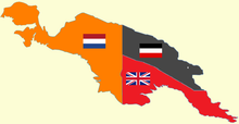
Kaiser-Wilhelmsland 1884-1919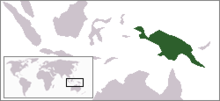
Geography Location northeastern half of the Island of New Guinea, north of Australian continent Coordinates 6°50′S 146°40′E / 6.833°S 146.667°ECoordinates: 6°50′S 146°40′E / 6.833°S 146.667°E Area 181,650 km2 (70,135 sq mi) Highest elevation 4,121 m (13,520 ft) Highest point Saruwaged Massif 6°18′39″S 147°05′27″E / 6.31083°S 147.09083°E Country Demographics Population 110,000 (as of 1902) Kaiser-Wilhelmsland was part of the German New Guinea, the South Pacific protectorate of the German Empire. Named in honor of Wilhelm II, who was the German Emperor and King of Prussia, it included the north-eastern part of the present day Papua New Guinea. From 1884 until 1918, the territory was a protectorate of the German Empire. Kaiser-Wilhelmsland, New Pomerania, the Bismarck Archipelago, the northern Solomon Islands, the Carolina Islands, Palau, Nauru, the Mariana Islands and the Marshall Islands comprised German New Guinea.
Most of the German settlers to Kaiser-Wilhelmsland were plantation owners, miners, and government functionaries, and the number of European settlers, including non-Germans, was never very high. In 1885, Lutheran and Catholic congregations sent clergy to establish missions, who experienced moderate, but very slow, success with the indigenous peoples. Missionaries and plantation owners alike were limited by tropical diseases, travel and communication barriers.
The protectorate was never fully explored by the Germans, although in 1914, the German government mounted an expedition to explore and map the interior. Lutheran missionaries were frequently the first Europeans to explore the interior and examine the different fauna and flora.
At the outbreak of war in 1914, the German protectorate was quickly over run by British-Australian troops. In 1918, as part of the settlements ending World War I, Kaiser-Wilhemsland was administered by the British Dominion of Australia.
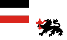 Imperial Colonial Flag of the German Empire
Contents
Natural features
Quaternary glaciers created much of the topography of Kaiser-Wilhelmsland. Recent studies suggest Mount Wilhelm held approximately 65 square kilometres (25 sq mi) of glacial ice.[1] Further north, closer to the Equator, the glaciers left behind large rubble fields.[2]
The territory of Kaiser Wilhelmsland was largely mountainous, with Mount Wilhelm 4,509 metres (14,793 ft) the highest peak of the Hagan Range, which separated the protectorate from the British Papua. There are several major rivers, notably the Sepik River 1,126 kilometres (700 mi) which drops from the Highlands and winds through lowland swamp plains to the north coast.
The Markham River flows 180 kilometres (112 mi) from the Finisterre Range and ends in the Huon Gulf. The Huon Peninsula, named for the French explorer Jean-Michel Huon de Kermadec, has raised beaches, usually created by the combination of tectonic coastal uplift and quaternary sea-level fluctuations. The Saruwaged massif, with its twin peaks of Bangeta and Saruwaged, dominate the Saruwaged Range; rugged and steep, the massif reaches 4,000 metres (13,123 ft), and is surrounded by jungles at its base.
Indigenous population
Near Mount Hagen, archeologists have identified the Kuk Swamp (5°47′1.36″S 144°19′54.2″E / 5.7837111°S 144.331722°E), one of the oldest agricultural drainage sites in Australasia; the site has been identified as a UNESCO site, and is on the list of recommended World Heritage sites.
Linguistic features suggest the origins of the population. Along the southeast coast and in the Markham Valley, the Austronesia family of languages predominate. The two main languages were Kâte and Yabim, with Kâte spoken in the mountainous hinterlands and Yabim, on the coastal areas, particularly on coast of the Huon peninsula. The Non-Austronesia languages are heard most commonly in the mountain regions.
Early exploration
The coastline of the northern and eastern portions of New Guinea had been charted by navigators in the early 17th century, and the visible mountain ranges named by British admiralty navigators later in the century. Most German surveying efforts had focused on coastal regions and river basins, where Germans had established plantations. The boundary between Papua and Kaiser Wilhelmsland had been established by a joint British-German expedition in 1909, the interior had not been mapped. Since then, Papuan gold prospectors had crossed into German territory which, from the German perspective, made the accuracy of the border essential.[3] In late 1913, the Imperial Colonial Office appointed Hermann Detzner to lead an expedition to survey the border between the British protectorate, called Papua and the German territory and to survey and map the interior. Detzner seemed to be the right man for the job.[4] Detzner's mission was also to be the first serious attempt to explore the unknown interior and to evaluate and describe its contents.
Settlement by Europeans
In 1882, the firms of German New Guinea Company and Plantation Society, and the Robertson and Hernsheim Company (later Hernsheim Company) secured the German business interests on the Island. The colony was dominated by the German New Guinea Company, and between 1884 and 1899 was actually administered by the company. The plantation owners, most of whom mined copper, or grew such tropical products as coconuts, focused their attention on the coastal regions, leaving exploration of the interior to the missionaries and military explorers.
In 1885–87, Johann Flierl established missionary stations in Simbang and Timba Island. After malaria epidemics in 1889 and again in 1891 killed almost half of the European settlers on the coast in Finschhafen, many of the Europeans moved toward Friedrich Wilhelmshafen (now Madang). Flierl established a Mission station at the Sattelberg, 700 metres (2,297 ft) in the highlands. In 1890–91, he built the Sattelberg Mission Station there and constructed a road approximately 24 kilometres (15 mi) between the station and the Finsch harbor (Finschhafen), which cut the traveling time from three days to five hours.[5]
Outbreak of World War I
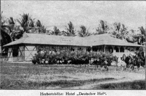
 German Barracks at Herbertshöhe (Kokopo) on New Pomerania, circa 1912. The small German colony in Herbertshöhe capitulated to the Australian troops by mid-September 1914.
On 4 August 1914, Britain declared war on Germany. As World War I spread to the Pacific, Australian troops invaded German New Guinea, taking the German barracks in Herbertshöhe (present day Kokopo) and forcing the defending German colonial troops to capitulate on 21 September after their defeat at Bita Paka.
Reorganization and Australian administration 1920-1945
In 1918, Kaiser Wilhelmsland and the other territories that comprised German New Guinea (New Pomerania and the islands of the Bismarck Archipilago) were administered by the Commonwealth of Australia. Beginning in 1920, Australia, under a mandate from the League of Nations, governed the former German territory of New Guinea. It was administered under this mandate until the Japanese invasion in December 1941 (Operation Mo). Most of the territory of New Guinea, including the islands of Bougainville, and New Britain, was occupied by Japanese forces before recapture during the final months of the war in the Australian-American New Guinea campaign.
See also
- Prefecture Apostolic of Kaiserwilhelmsland
- Dutch New Guinea
- Unserdeutsch language
Citations
- ^ J. A. Peterson, S Chandra and C Lundberg, Landforms from the Quaternary glaciation of Papua New Guinea: an overview of ice extent during the LGM.pp. 1-18
- ^ Peterson, p. 13.
- ^ Linke, p. 3; K. L. Spinks, "The Wahgi River Valley of Central New Guinea," The Geographical Journal, 87:3, March 1936, 222–28, p. 222.
- ^ Robert Linke, The influence of German surveying on the development of New Guinea, Shaping the Change: XXIII FIG Congress, Munich, Germany, October 8–13, 2006, pp. 1-17, p. 10.
- ^ Sack, P. G. "Flierl, Johann (1858 - 1947)," Australian Dictionary of Biography, Online Edition, 2006, updated continuously, Australian National University. ISSN 1833-7538.
External links
- Prefecture Apostolic of Kaiserwilhelmsland - Catholic Encyclopedia article
Former German colonies and protectorates Colonies AfricaPacificNorth AmericaGerman Caribbean

Concessions ChinaUnrecognised AntarcticaCategories:- History of Papua New Guinea
- German New Guinea
- Christian missions
- Former protectorates


Wikimedia Foundation. 2010.