- Mount Macedon, Victoria
-
For other uses, see Macedon (disambiguation).
Mount Macedon
Victoria
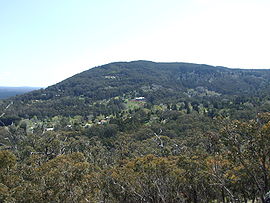
Mount Macedon village from nearby Mount TowrongPopulation: 1,694 (2006)[1] Postcode: 3441 Elevation: 615 m (2,018 ft) Location: LGA: Shire of Macedon Ranges State District: Macedon Federal Division: McEwen Localities around Mount Macedon: Woodend Woodend Newham Macedon Mount Macedon Riddells Creek Macedon Gisborne New Gisborne Mount Macedon (pronounced /maʊnt ˈmæsədən/)[2] is a small town located 64 kilometres (40 mi) northwest of Melbourne in the Australian state of Victoria. It is situated on the side of the mountain of the same name, known as Geboor (or Geburrh)[3] by the indigenous Wurundjeri people, which rises to 1,001 metres (3,284 ft) above sea level. At the 2006 census, Mount Macedon had a population of 1,694. Mount Macedon is best known for its collection of 19th century gardens and associated extravagant large homes which is considered to be one of the most important such collections in Australia.
Mount Macedon township was largely established by Melbourne's wealthy elite in the post gold rush era of the mid to late 19th century who used it as a summer retreat. The Post Office opened on 18 July 1870, known as Upper Macedon until 1879 and Macedon Upper until 1936. An earlier (1843) Mount Macedon office was renamed Kyneton.[4]
The mountain was originally sighted by Hamilton Hume and William Hovell on their 1824 expedition to Port Philip from NSW. They named it Mount Wentworth.[5] It was renamed Mount Macedon by explorer Major Thomas Mitchell who ascended the mountain in 1836.[3] He named it after Philip of Macedon in honour of the fact that he was able to view Port Philip from the summit. Several other geographic features along the path of his third 'Australia Felix' expedition were named after figures of Ancient Macedonia including the nearby Campaspe River and Mount Alexander near Castlemaine (named after Alexander the Great).
Due to its relatively high elevation (Mount Macedon village is around 620 metres (2,030 ft) above sea level), the area experiences much cooler temperatures on average relative to nearby Melbourne. The area also receives high rainfall relative to the surrounding plains and much of the Melbourne area. This combination of geographic factors have contributed to the town's reputation as a resort town and wine region. [6].
Snowfall is a fairly regular feature on the higher elevations of the mountain, although the peak of the mountain is marginally too low for snowfalls to lie on the ground for more than a few days in most instances. Occasionally, the lower parts of the town experience snowfalls and on occasion these have been substantial.
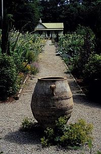
The gardens and homes of Mount Macedon are well known for their lavish size and scale, many of which contain collections of exotic plants that are rare in cultivation.
Contents
Attractions
Memorial Cross
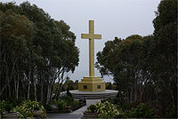
One of the major attractions of Mount Macedon is the 21-metre (69 ft) high memorial cross which stands near the summit of the mountain. This structure was established by early resident William Cameron in 1935 as a memorial to his son and those who died in World War I. The view from the summit of Mount Macedon is spectacular and takes in Melbourne city, the Dandenong Ranges and the You Yangs near Geelong.
Forestry
Another attraction of the Mount Macedon area is the extensive native forests which cover the mountain and surround the town. Much of the forest on Mount Macedon consists of wet sclerophyll communities which are more commonly associated with areas east of Melbourne. Alpine Ash (Eucalyptus delegatensis) occurs here at the western extent of its range and Mountain Ash (Eucalyptus regnans) at the northwestern extent of its range, Snow Gums (Eucalyptus pauciflora) are also found on the highest peaks. A large area of the Macedon Ranges forest is included in the Macedon Regional Park, managed by Parks Victoria.[7]
The area was devastated by the Ash Wednesday fires of 1983, but the forests and gardens have since regrown.
Camels Hump
The Mount Macedon area also comprises a second important peak, The Camels Hump, rising to 1,011 metres (3,317 ft) above sea level. The volcanic trachyte rock of the crag is favoured by rock climbers and the mountain has become a popular sport climbing venue due to its proximity to Melbourne.
Private Gardens
Hascombe is a large garden owned by Linfox. It has an annual open day where all money received goes to charity. It only has two gardeners working for the whole 28-acre (11 ha) property. It has one of only two Himalayan Fir (Abies pindrow) trees in Australia, the other being located in Adelaide. It is the highest private property on Mount Macedon by altitude.
Across Alton Road from Hascombe, is the garden Alton. It has been the filming location for films such as Macbeth, mainly due to its historic residence surrounded by an English garden.
Film Industry
Mount Macedon is becoming a very popular location with the US film industry due to lower costs associated with filming outside the US and the architecture and horticulture of the area closely resembling places in the Northern Hemisphere with an abundance of deciduous trees.
The 2009 Nicolas Cage film Knowing was filmed in locations in the township along with nearby Macedon and the future release Don't Be Afraid of the Dark was also filmed in the town over the 2009 winter.
Scenes in "Where the Wild Things Are" were filmed in the forest surrounding Mount Macedon[8][9]
Sport
Golfers play at the course of the Mount Macedon Golf Club on Mount Macedon Road.[10]
References
- ^ Australian Bureau of Statistics (25 October 2007). "Mount Macedon (State Suburb)". 2006 Census QuickStats. http://www.censusdata.abs.gov.au/ABSNavigation/prenav/LocationSearch?collection=Census&period=2006&areacode=SSC26233&producttype=QuickStats&breadcrumb=PL&action=401. Retrieved 2007-10-01.
- ^ Macquarie Dictionary, Fourth Edition (2005). Melbourne, The Macquarie Library Pty Ltd. ISBN 1-876429-14-3
- ^ a b Milbourne, Jean (1978), Mount Macedon: Its History and its Grandeur, Kyneton: (self published), pp. 10, 14, ISBN 0-9595225-0-6
- ^ Premier Postal History, Post Office List, https://www.premierpostal.com/cgi-bin/wsProd.sh/Viewpocdwrapper.p?SortBy=VIC&country=, retrieved 2008-04-11
- ^ Bland, William; Hovell, William Hilton; Hume, Hamilton (1831), Journey of discovery to Port Phillip, New South Wales by Messrs. W.H. Hovell, and Hamilton Hume in 1824 and 1825, Sydney, http://gutenberg.net.au/ebooks04/0400371.txt
- ^ Victoria, Tourism (2011), Macedon Ranges Wine Region, http://www.visitvictoria.com/Regions/Daylesford-and-the-Macedon-Ranges/Activities-and-attractions/Food-and-wine/Macedon-Ranges-wine-region.aspx, retrieved 2011-07-25
- ^ Parks Victoria, Macedon Regional Park,, http://www.parkweb.vic.gov.au/1park_display.cfm?SortBy=VIC&country=, retrieved 2008-11-28
- ^ http://www.imdb.com/title/tt1270761/locations
- ^ http://www.imdb.com/title/tt0448011/locations
- ^ Golf Select, Mount Macedon, http://www.golfselect.com.au/armchair/courseView.aspx?course_id=1040, retrieved 2009-05-11
External links
- Mount Macedon - Official tourism site
- The Gallery Mount Macedon Artabase page
- Mount Macedon, Victoria is at coordinates 37°24′18″S 144°34′59″E / 37.405°S 144.583°ECoordinates: 37°24′18″S 144°34′59″E / 37.405°S 144.583°E
Towns and localities in the Shire of Macedon Ranges
(major towns in bold)Ashbourne · Baynton · Bolinda · Bullengarook · Carlsruhe · Cherokee · Clarkefield · Cobaw · Darraweit Guim · Gisborne · Gisborne South · Hesket · Kerrie · Kyneton · Lancefield · Lauriston · Macedon · Malmsbury · Monegeetta · Monegeetta North · Mount Macedon · New Gisborne · Newham · Riddells Creek · Rochford · Romsey · Springfield · Tylden · Woodend · Woodend North
Categories:- Towns in Victoria (Australia)
- Gardens in Australia
- Macedon Ranges
Wikimedia Foundation. 2010.


