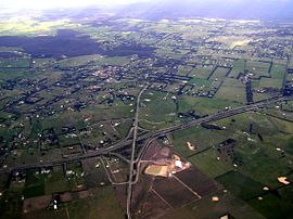
- Gisborne South, Victoria
-
Gisborne South
Victoria
Aerial photo of Gisborne southPopulation: 742[1] Postcode: 3437 Elevation: 443 m (1,453 ft) LGA: Shire of Macedon Ranges State District: Macedon Federal Division: McEwen Localities around Gisborne South: Gisborne Gisborne Riddells Creek Bullengarook Gisborne South Sunbury Wombat State Forest Toolern Vale Sunbury Gisborne South, also known as Couangalt,[2][3] is a locality in the Macedon Ranges Shire, in Victoria, Australia, north west of the city of Melbourne. At the 2006 census, Gisborne South had a population of 742.[1] The area formerly had its own post office.[2]
References
- ^ a b Australian Bureau of Statistics (25 October 2007). "Gisborne South (State Suburb)". 2006 Census QuickStats. http://www.censusdata.abs.gov.au/ABSNavigation/prenav/LocationSearch?collection=Census&period=2006&areacode=SSC25647&producttype=QuickStats&breadcrumb=PL&action=401. Retrieved 9 May 2010.
- ^ a b Victorian Municipal Directory. Brunswick: Arnall & Jackson. 1956. p. 639.
- ^ Melway Edition 33, 2006
Towns and localities in the Shire of Macedon Ranges
(major towns in bold)Ashbourne · Baynton · Bolinda · Bullengarook · Carlsruhe · Cherokee · Clarkefield · Cobaw · Darraweit Guim · Gisborne · Gisborne South · Hesket · Kerrie · Kyneton · Lancefield · Lauriston · Macedon · Malmsbury · Monegeetta · Monegeetta North · Mount Macedon · New Gisborne · Newham · Riddells Creek · Rochford · Romsey · Springfield · Tylden · Woodend · Woodend North
Coordinates: 37°32′19″S 144°36′23″E / 37.53861°S 144.60639°E
Categories:- Towns in Victoria (Australia)
- Macedon Ranges
- Victoria (Australia) geography stubs
Wikimedia Foundation. 2010.
