- Manatí, Puerto Rico
-
"Manatí" redirects here. For other uses, see Manatí (disambiguation).
Manatí, Puerto Rico — Municipality — 
Flag
Coat of armsNickname(s): "Ciudad Metropolitana", "La Atenas de Puerto Rico" Anthem: "Atenas de Borinquen" Location of Manatí in Puerto Rico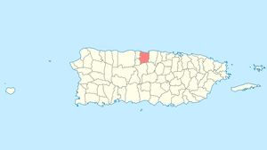
Coordinates: 18°25′57″N 66°29′4″W / 18.4325°N 66.48444°WCoordinates: 18°25′57″N 66°29′4″W / 18.4325°N 66.48444°W Country United States Territory Puerto Rico Founded 1738 Government - Mayor Juan "Bin" Cruz Manzano (PNP ) - Senatorial dist. 3 - Arecibo - Representative dist. 12, 13 Area - Total 56.2 sq mi (145.53 km2) - Land 46.3 sq mi (120 km2) - Water 9.9 sq mi (25.53 km2) Population (2000) - Total 45,409 - Density 808.1/sq mi (312/km2) Demonym Manatieños Time zone AST (UTC-4) Zip code Manatí (Spanish pronunciation: [manaˈti]) is a municipality of Puerto Rico in the northern coast, north of Morovis and Ciales; east of Florida and Barceloneta; and west of Vega Baja. Manatí is spread over 8 wards and Manatí Pueblo (The downtown area and the administrative center of the city). It is part of the San Juan-Caguas-Guaynabo Metropolitan Statistical Area.
Contents
Barrios (districts/wards)
- Bajura Adentro[1]
- Bajura Afuera
- Coto Norte
- Coto Sur
- Los Rabanos
- Manatí Pueblo
- Río Arriba Poniente
- Río Arriba Saliente
- Tierras Nuevas Poniente
- Tierras Nuevas Saliente
History
Manatí was founded in 1738 by Don Pedro Menendez Valdes. It is named after a sea mammal, the manatee (which are also known as sea cows). During those early years, the Mayor of the town was Jose Aulet. The family was rich in pineapple, sugar cane, and green bananas. The Aulets sold the land to the government in 1985.
Economy
Isidoro Colón established the Sugar Cane "Candelaria" in the years between 1860 and 1870, located between Manatí and Barceloneta.
Agriculture
Manatí is the pineapple center of Puerto Rico. In addition, grows in its surroundings fruits, sugar cane, and coffee.
Industry
Manufacture (pharmaceutics)
José Abraham Rosario initiated the "Publicidad Rosario" on 1945.
Radio stations
Tourism
Landmarks and places of interest
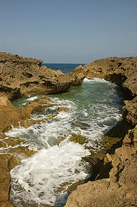 Near Mar Chiquita Beach
- The Acropolis Sports Complex
- El Salón del Poeta
- Historic Zone
- Los Tubos Beach
- los chicos
- Mar Chiquita Beach
- Marqués de la Esperanza Hacienda Ruins
- Ruinas de la Oficina de la Central Monserrate
Festivals and events
- Patron Fetivities - February: "La Virgen De La Candelaria"
- Cross Festivities - May
- Beach Festival - July
- Manatee Festival - July
- Halloween Festival - October
- Christmas Festival - December
References
Categories:- Manatí, Puerto Rico
- Populated places established in 1738
- San Juan – Caguas – Guaynabo metropolitan area
- Municipalities of Puerto Rico
- Puerto Rico geography stubs


Wikimedia Foundation. 2010.