- Vieques, Puerto Rico
Infobox Settlement
official_name = Vieques, Puerto Rico
other_name =
native_name =
nickname = Isla Nena (Baby Girl Island)
settlement_type = Municipality
motto =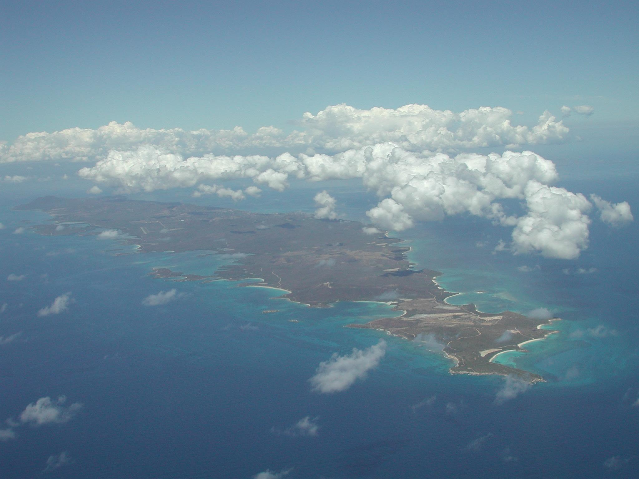
imagesize =
image_caption = Vieques from the air, looking west
flag_size =
image_
seal_size =
image_shield = Coat_of_Arms_of_Vieques,_Puerto_Rico.png
city_logo =
citylogo_size =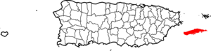
mapsize =
map_caption = Location withinPuerto Rico
mapsize1 =
map_caption1 =
image_dot_
dot_mapsize =
dot_map_caption =
dot_x = |dot_y =
pushpin_
pushpin_label_position =
pushpin_map_caption =
pushpin_mapsize =
subdivision_type = Country
subdivision_name =United States subdivision_type1 = Territory
subdivision_name1 =Puerto Rico
subdivision_type2 =
subdivision_name2 = =
government_footnotes =
government_type =
leader_title =Mayor
leader_name =Damaso Serrano López
leader_title1 =
leader_name1 =
leader_title2 =
leader_name2 =
leader_title3 =
leader_name3 =
leader_title4 =
leader_name4 =
established_title =
established_date =
established_title2 =
established_date2 =
established_title3 =
established_date3 =
area_magnitude = 1 E9
unit_pref =
area_footnotes =
area_total_km2 =348.15
area_land_km2 =135
area_water_km2 =213.15
area_total_sq_mi =
area_land_sq_mi =
area_water_sq_mi =
area_water_percent =
area_urban_km2 =
area_urban_sq_mi =
area_metro_km2 =
area_metro_sq_mi =
area_blank1_title =
area_blank1_km2 =
area_blank1_sq_mi =
population_as_of =2000
population_footnotes =
population_note =
population_total =9,106
population_density_km2 =67.5
population_density_sq_mi =
population_metro =
population_density_metro_km2 =
population_density_metro_sq_mi =
population_urban =
population_density_urban_km2 =
population_density_urban_sq_mi =
population_blank1_title =Demonym
population_blank1 =Viequenses
population_density_blank1_km2 =
population_density_blank1_sq_mi =
timezone = AST
utc_offset = -4
timezone_DST =
utc_offset_DST =
population_blank2_title = Racial groups
(2000 Census) [ [http://www.topuertorico.org/pdf/2kh72.pdf Demographics/Ethnic U.S 2000 census] ]
population_blank2 = 72.7% White 13.8% Black 0.4% American Indian/An 0.6% Asian 0.8%Native Hawaiian /Pi 8.8% Some other race 3.4% Two or more races|
latd=18 |latm=07 |lats= |latNS=N
longd=65 |longm=25 |longs= |longEW=W
elevation_footnotes =
elevation_m =
elevation_ft =
postal_code_type =
postal_code =
area_code =
blank_name =
blank_info =
blank1_name =
blank1_info =
website = [http://www.viequesrenace.com www.viequesrenace.com]
footnotes =Vieques (: IPA|/'vjɛkɛs/ or /'bjɛkɛs/ or /'βjɛkɛs/; : IPA| [viːˈeɪkeɪz] or IPA| [-kɛz] ), in full Isla de Vieques, is an island-municipality of
Puerto Rico in the northeasternCaribbean . Although Puerto Rico is a U.S. Commonwealth, Vieques, like the rest of Puerto Rico, retains strong Spanish influences from 400 years of Spanish ownership.Vieques lies about convert|8|mi|km|0 to the east of the Puerto Rican mainland, and measures approximately convert|21|mi|km|0 long by convert|4|mi|km|0 wide. The two main towns of Vieques are Isabel Segunda (sometimes written "Isabel II"), the administrative center located on the northern side of the island, and Esperanza, located on the southern side. At peak, the population of Vieques is around 10,000.
The island's name is a Spanish spelling of a Native American word said to mean "small island". It also has the nickname "Isla Nena", usually translated from the Spanish as "Little Girl Island", as a reference to its being perceived as Puerto Rico's little sister island. During the colonial period the British name was "Crab Island".
Vieques is best known internationally as the site of a series of protests against the US Navy's use of the island as a bombing range and weapons testing ground, which eventually led to the Navy's departure in 2003.
History
Pre-Columbian history
Archaeological evidence suggests that Vieques was first inhabited by ancient Native American peoples who travelled from continental America perhaps between 3000 BC and 2000 BC. However, estimates of these prehistoric dates of inhabitation vary widely. These tribes had a Stone Age culture and were probably fishermen and hunter-gatherers.
Excavations at the Puerto Ferro site by Luis Chanlatte and Yvonne Narganes [American Antiquity, Vol. 57, No. 1 (Jan. 1992) pp. 146-163.] uncovered a fragmented human skeleton in a large hearth area. Radiocarbon dating of shells found in the hearth indicate a burial date of c.1900 BCE. This skeleton, popularly known as "El Hombre de Puerto Ferro", was buried at the center of a group of large boulders near the south-central coast of Vieques, approximately one kilometer northwest of the Bioluminescent Bay. Linear arrays of smaller stones radiating from the central boulders are apparent at the site today, but their age and reason for placement are unknown. Further waves of settlement by Native Americans followed over many centuries. The
Arawak -speakingSaladoid (orIgneri ) people, thought to have originated in modern-day Venezuela, arrived in the region perhaps around 200 BC (again estimates vary). These tribes, noted for their pottery, stone carving, and other artifacts, eventually merged with groups fromHispaniola andCuba , to form what is now called theTaino culture. This culture flourished in the region from around 1000 AD, and survived on Vieques until the arrival of the Europeans in the 15th century.Colonial period
The European discovery of Vieques is sometimes credited to
Christopher Columbus , who landed in Puerto Rico in 1493. It does not seem to be certain whether Columbus personally visited Vieques, but in any case the island was soon claimed by the Spanish. During the early 16th century Vieques became a center of Taino rebellion against the European invaders, prompting the Spanish to send armed forces to the island to quell the resistance. The native Taino population was decimated, and its people either killed, imprisoned or enslaved by the Spanish.The Spanish did not, however, permanently colonise Vieques at this time, and for the next three hundred years it remained a lawless outpost, frequented by pirates and outlaws. As European powers fought for control in the region, a series of attempts by the French, English and Danish to colonise the island in the 17th and 18th centuries were repulsed by the Spanish.
At the beginning of the 19th century, the Spanish took steps to permanently settle and secure the island. In 1811,
Don Salvador Meléndez , then governor of Puerto Rico, sent military commanderJuan Rosselló to begin what would become the annexation of Vieques by the Puerto Ricans. In 1832, under an agreement with the Spanish Puerto Rican administration, FrenchmanTeófilo José Jaime María Le Guillou became Governor of Vieques, and undertook to impose order on the anarchic province. He was instrumental in the establishment of large plantations, marking a period of social and economic change for the island. Le Guillou is now remembered as the "founder" of Vieques (though this title is also sometimes conferred on Francisco Saínz, governor from 1843 to 1852, who founded Isabel Segunda, the "town of Vieques", named after Queen Isabel II of Spain). Vieques was formally annexed to Puerto Rico in 1854.In 1816, Vieques was briefly visited by
Simón Bolívar while fleeing defeat in Venezuela.During the second part of the 19th century, thousands of black immigrants came to Vieques to work on the
sugar cane plantation s. They arrived from the nearby islands of St. Thomas,Nevis ,St. Kitts ,St. Croix , and many otherCaribbean nations, some asslave s and some as independent economic migrants. Since this time black people have formed an important part of Vieques’ society.US acquisition
In 1898, after Spain's defeat in the
Spanish–American War , Vieques, along with mainland Puerto Rico, was ceded to theUnited States .In the 1920s and 1930s, the sugar industry, on which Vieques was totally dependent, went into decline due to falling sugar prices and industrial unrest. Many locals were forced to move to mainland Puerto Rico or
St. Croix to look for work.During
World War II , the United States military purchased about two thirds of Vieques as an extension to the Roosevelt Roads base nearby on the Puerto Rican mainland. The original purpose of the base (never implemented) was to provide a safe haven for the British fleet should Britain fall to Germany. Much of the land was bought from the owners of large farms and sugar cane plantations, and the purchase triggered the final demise of the sugar industry. Many agricultural workers, who had no title to the land they occupied, were evicted. [ [http://www.sscnet.ucla.edu/soc/faculty/ayala/vieques/Papers/06ayalacentro.pdf "From Sugar Plantations to Military Bases: the U.S. Navy’s Expropriations in Vieques, Puerto Rico"] , César Ayala.]After the war, the US Navy continued to use the island for military exercises, and as a firing range and testing ground for
bomb s,missile s, and other weapons in a manner not unlikeKahoolawe in theHawaiian Islands .Protests and departure of the US Navy
The continuing post-war presence in Vieques of the US Navy drew protests from the local community, angry at the expropriation of their land and the environmental impact of weapons testing. The locals' discontent was exacerbated by the island's parlous economic condition.
These protests came to a head in 1999 when Vieques native
David Sanes was killed by a bomb dropped during target practice. A campaign of civil disobedience began. The locals took to the ocean in their small fishing boats and successfully stopped the US Navy's military exercises. The Vieques issue became something of a "cause celèbre", and local protestors were joined by sympathetic groups and prominent individuals from mainland USA (such asEdward James Olmos ) and abroad.As a result of this pressure, in May 2003 the Navy withdrew from Vieques, and much of the island was designated a wildlife reserve under the control of the
US Fish and Wildlife Service . Closure of the Roosevelt Roads base followed in 2004.Politics
Government
Vieques is a municipio of Puerto Rico, translated as "
municipality " and in this context roughly equivalent to "township". It is in the Puerto Rican electoral district of Carolina. Local government is under the leadership of a mayor (Spanish "alcalde"), presently Dámaso Serrano López. Like the rest of Puerto Rico, the head of state is thePresident of the United States .Administrative divisions
Administratively Vieques is divided into Isabel Segunda plus seven wards:cite web|url=http://factfinder.census.gov/servlet/GCTTable?_bm=y&-context=gct&-ds_name=DEC_2000_SF1_U&-mt_name=DEC_2000_SF1_U_GCTPH1_CO2&-tree_id=4001&-redoLog=true&-_caller=geoselect&-geo_id=05000US72147&-format=CO-2&-_lang=en|title=US Census (2000), Vieques Municipio, Puerto Rico -- County Subdivision and Place|accessdate=2007-04-20]
These are often referred to as "
barrio s", though this term is also applied to various other localities and townships on the island.Geography
Vieques measures about 21 miles (34 km) east-west, and three to four miles (5 km) north-south. It has a land area of 52 square miles (135 km²) and is located about ten miles (16 km) to the east of Puerto Rico. To the north of Vieques is the Atlantic ocean, and to the south the Caribbean Sea. The island of Culebra is about 10 miles (16 km) north of Vieques, and the
US Virgin Islands lie to the east. Vieques and Culebra, together with various small islets, make up the so-calledSpanish Virgin Islands , sometimes known as the Passage Islands.The former US Navy lands, now wildlife reserves, occupy the entire eastern and western ends of Vieques, with the former live weapons testing site (known as the "LIA", or "Live Impact Area") at the extreme eastern tip. These areas are unpopulated. The former civilian area occupies very roughly the central third of the island and contains the towns of Isabel Segunda on the north coast, and Esperanza on the south.
National
protected area *
Vieques National Wildlife Refuge Geology
Vieques has a terrain of rolling hills, with a central ridge running east-west. The highest point is Monte Pirata ("Pirate Mount") at 987 feet (300 m). Geologically the island is composed of a mixture of volcanic bedrock, sedimentary rocks such as
limestone andsandstone , and alluvial deposits of gravel, sand, silt, and clay. There are no permanent rivers or streams. Much former agricultural land has been reclaimed by nature due to prolonged disuse, and, apart from some small-scale farming in the central region, the island is largely covered by brush and subtropical dry forest. Around the coast lie palm-fringed sandybeach es interspersed with lagoons, mangrove swamps,salt flat s andcoral reef s.Climate
Vieques has a warm, relatively dry, tropical to sub-tropical climate. Temperatures vary little throughout the year, with average daily maxima ranging from 82 °F (28 °C) in January to 87 °F (31 °C) in July. [ [http://www.weatherbase.com/weather/weatherall.php3?s=785353&refer=&units=us weatherbase.com] ] Average daily minima are about 10 °F (6 °C) lower. Rainfall averages around 45 to 55 inches (1150 to 1400 mm) per year, with the months of May and September–November being the wettest. The west of the island receives significantly more rainfall than the east. Prevailing winds are easterly.
Vieques is prone to tropical storms and at risk from hurricanes from June to November. In 1989
Hurricane Hugo caused considerable damage to the island. [ [http://marine.usgs.gov/fact-sheets/prstorm/prstorm.html U.S. Geological Survey report] ]Economy
The sugar industry, once the mainstay of the island's economy, declined during the early decades of the twentieth century, and finally collapsed in the 1940s when the US Navy took over much of the land on which the sugar cane plantations stood. After an initial naval construction phase, opportunities for making a living on the island were largely limited to fishing or subsistence farming on reduced area. Crops grown on the island include avocados, bananas, coconuts, grains, papayas and sweet potatoes. A small number of permanent local jobs were provided by the US Navy. Since the 1970's
General Electric employs a few hundred workers at a manufacturing plant. Unemployment was widespread, with consequent social problems. The 2000 US census reported a median household income in 1999 dollars of $9,331 (compared to $41,994 for the USA as a whole), and 35.8% of the population of 16 years and over in the labor force (compared to 63.9% for the USA as a whole).cite web|url=http://factfinder.census.gov/servlet/SAFFFacts?_event=&geo_id=05000US72147&_geoContext=01000US%7C04000US72%7C05000US72147&_street=&_county=vieques&_cityTown=vieques&_state=&_zip=&_lang=en&_sse=on&ActiveGeoDiv=&_useEV=&pctxt=fph&pgsl=050&_submenuId=factsheet_1&ds_name=DEC_2000_SAFF&_ci_nbr=null&qr_name=null®=null%3Anull&_keyword=&_industry=|title=US Census (2000)|accessdate=2007-04-17]Like the rest of Puerto Rico, the island's currency is the US dollar.
Following the 2003 departure of the US Navy, efforts have been made to redevelop the island's agricultural economy, to clean up contaminated areas of the former bombing ranges, and to develop Vieques as a tourist destination.
Tourism
For sixty years the majority of Vieques was closed off by the US Navy, and the island remained almost entirely undeveloped for tourism. This lack of development is now marketed as a key attraction. Vieques is promoted under an
ecotourism banner as a sleepy, unspoilt island of rural "old world" charm and pristine deserted beaches, and is rapidly becoming a popular destination.Since the Navy's departure, tensions on the island have been low, although land speculation by foreign developers and fears of overdevelopment have caused some resentment among local residents, and there are occasional reports of lingering anti-American sentiment.
The lands previously owned by the Navy have been turned over to the U.S. National Fish and Wildlife Service and the authorities of Puerto Rico and Vieques for management. The immediate bombing range area on the eastern tip of the island suffers from severe contamination, but the remaining areas are mostly open to the public, including many beautiful beaches that were inaccessible to
civilians when the military bases were open.Snorkeling is excellent, especially at Blue Beach (Bahía de la Chiva). Aside from archeological sites, such as La Hueca, and deserted beaches, a unique feature of Vieques is the presence of two pristine bioluminescent bays, including Mosquito Bay. Vieques is also famous for its wild or semi-wild horses, which roam free over parts of the island. These are descended from stock originally brought by European colonisers.
Landmarks and places of interest
*Fortín Conde de Mirasol (Count Mirasol Fort), a fort built by the Spanish in the mid 19th century, now a museum
*Playa Esperanza (Esperanza Beach)
*The tomb of Le Guillou, the town founder, in Isabel Segunda
*Old Nayda Cinema Theater
*Faro Punta Mulas (Punta Mulas Lighthouse), built in 1896
*Sun Bay Beach
*The Bioluminescent Bay
*The 300-year-oldceiba treeBioluminescent Bay
The
Bioluminescent Bay (or "Bio Bay" as it is sometimes called), is perhaps the world's largest and brightest. The luminescence is caused by micro-organisms (dinoflagellates ) which glow whenever the water is disturbed, leaving a trail of neon blue. A combination of factors create the necessary conditions for bioluminescence:red mangrove trees surround the water (the organisms feed off the dead leaves), a complete lack of modern development around the bay, the water is cool enough and deep enough, and a small channel to the ocean keeps the dinoflagellates in the bay. This small channel is the result of Spanish ships's attempts to choke off the bay from the ocean's waters. The Spanish believed that the bioluminescence they first encountered was the work of the Devil ('El Diablo') and tried to block the ocean's waters from entering the bay by dropping huge boulders in the channel. The Spanish only succeeded in preserving and increasing the luminescence. Kayaking and swimming are permitted in the bay and can be arranged through local vendors.Festivals and events
*Cultural Festival – April
*Festival Viequense – July
*Matron Celebrations – December
*Bilí Festival – November
*Arepa Festival – NovemberDemographics
Racial distribution

Wikimedia Foundation. 2010.