- Luquillo, Puerto Rico
Infobox Settlement
settlement_type =
subdivision_type = Country
subdivision_name =United States subdivision_type1 = Territory
subdivision_name1 =Puerto Rico
subdivision_type2 =
subdivision_name2 =timezone=AST
utc_offset=-4
timezone_DST=
utc_offset_DST=
unit_pref=Imperial
map_caption =Location of PAGENAME within Puerto Rico.
latNS=N
longEW=W| official_name = Luquillo, Puerto Rico |
image_caption = Aerial view of Luquillo
nickname = Capital del Sol", "La Riviera de Puerto Rico", "Los Come Cocos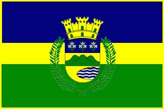
image_
| population_blank1 = Luquillenses|population_blank1_title=Gentilic| | population_blank1 = Luquillenses|population_blank1_title=Gentilic|
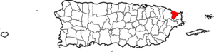
| map_caption = Location within the island ofPuerto Rico
established_date = 1797 | leader_title|established_title=Founded| =Mayor | leader_title=Mayor
leader_name = Hon. José "Nelo" González
political party = Partido Nuevo Progresista
leader_party = PNP
leader_title1=Senatorial dist.
leader_name1= 8 - Carolina
leader_title2=Representative dist.
leader_name2 = 36| area_magnitude = | area_total_km2 = 88.73
area_land_km2 = 68| area_water_km2 = 20.73| population_as_of = 2000 | population_note =
population_total = 19,817|population_footnotes= | population_density_km2 = 283.1| timezone = AST | utc_offset = -4 | timezone_DST = | utc_offset_DST = -4| latd= |latm= |lats=
longd=|longm= |longs=
population_blank2_title =Racial group s (2000 Census) [ [http://www.topuertorico.org/pdf/2kh72.pdf Demographics/Ethnic U.S 2000 census] ]
population_blank2 = 68.3% White 12.8% Black
0.6% American Ind/An
0.3% Asian 0.0%Native Hawaiian /Pi
14.8% Some other race
3.1% Two or more races|latitude =
longitude =
website =
footnotes = Anthem – "Junto a las costas del mar Atlántico" |Luquillo (loo-KEE-yo) is a
municipality ofPuerto Rico located in the northeast coast, northwest of Fajardo; and east of Rio Grande. Luquillo is spread over 5 wards and Luquillo Pueblo (The downtown area and the administrative center of the city).History
Luquillo is known as "La Capital del Sol" (sun capital) and "La Riviera de Puerto Rico" (Puerto Rico's riviera). Luquillo was founded in 1797 by Cristóbal Guzmán. The town was named after the Indian
cacique Loquillo, who died a few years after the last Indian rebellion in 1513.Flag
It consists of three horizontal stripes, the blue top and green bottom are double of width of the yellow central stripe. Blue makes reference to the sky and the sea; yellow represents the sand of its beaches and green represents the vegetation of the mountains. In the center stripe resides the Coat Of Arms of the town superimposed and surrounded by two palm tree leaves crossed at the bottom.
Coat of Arms
In a gold background a centered mountain range with three green mountains is accompanied at the bottom by a bay with blue and silver waves; the top portion of the shield in blue, has three iris branches. Above the shield resides a three tower gold crown. Surrounding the shield by its flanks are two palms trees leaves crossed at the bottom.
Demographics
Racial distribution
Wikimedia Foundation. 2010.