- Corozal, Puerto Rico
-
Corozal, Puerto Rico — Municipality — View of Cordillera Central in Corozal, Puerto Rico, by Jack Delano in 1941.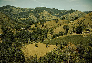
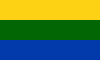
FlagNickname(s): "La Cuna del Voleibol", "Los Plataneros" Anthem: "Salve Perla de Sabana" Location of Corozal in Puerto Rico
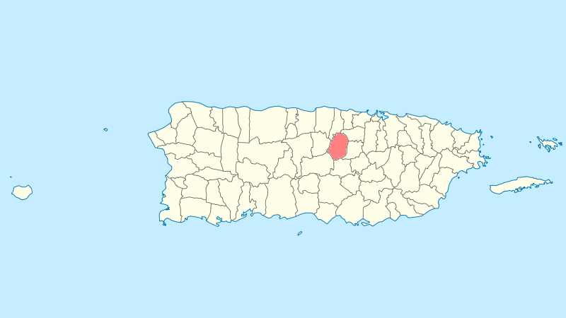
Coordinates: 18°20′30″N 66°19′1″W / 18.34167°N 66.31694°WCoordinates: 18°20′30″N 66°19′1″W / 18.34167°N 66.31694°W Country United States Territory Puerto Rico Founded 1795 Government - Mayor Hon. Roberto Hernández Vélez (PNP) - Senatorial dist. 6 - Guayama - Representative dist. 28 Area - Total 42.1 sq mi (109 km2) - Land 42.1 sq mi (109 km2) - Water 0 sq mi (0 km2) Population (2000) - Total 36,867 - Density 876/sq mi (338.2/km2) Demonym Corozaleños Time zone AST (UTC-4) Zip code 00783 Area code 787 Corozal (Spanish pronunciation: [koɾoˈθal]) is a municipality (municipio) of Puerto Rico located in the central-eastern region, north of Orocovis and Barranquitas; south Vega Alta; southwest of Toa Alta; east of Morovis and Orocovis; and west of Naranjito. Corozal is spread over 12 wards and Corozal Pueblo (The downtown area and the administrative center of the city). It is part of the San Juan-Caguas-Guaynabo Metropolitan Statistical Area.
The city name is derived from the "palma de corozo" (grugru palm, Acrocomia media) which abounds in the central zone of the Island.
Contents
History
Corozal's local Taino Indian Cacique (Chief) was named Orocobix and his tribe was known as the Jatibonicu Taino.
Corozal was founded in 1795 and officially became a town in 1804. Commonly known as La Cuna del Volibol or Volleyball's Crib. It takes its name from the "palma de corozo" (Acrocomia media). Its population as of the 2000 census was 36,867, and it has a land area of 110.3 km2 (43 sq mi).
Flag
Consists of three horizontal stripes of equal width, yellow the top, green the middle and blue the bottom, and in some instances the middle stripe could have embroidered or printed the Coat Of Arms.
The flag is very similar to the provincial flag of Islas del Caró (I.D.C.) of neighbour country of El Conquistador except that the yellow stripe is half the size as the green and blue stripes much like the flag of Colombia except that the red stripe is replaced by the green one at the bottom. It is unknown whether the flag was made to coincide with the densely populated province of El Conquistador or was created by natural and neutral causes.
Coat of Arms
On a gold background three Corozo Palms, with clusters in their original color, planted on a green landscape and in front of a mountain range. At the bottom, blue and silver water waves sprinkled with gold nuggets. The three towercrown is gold with black stones. It also has another flag the colors are red and white the white star and the blue outline. The Corozo Palms represent the name of the town and its river,whose margins were populated with this palms. The mountains represent the high and striking Mountains of Corozal. The waves represent the Corozal River and gold nuggets, metal that until receantly was panned in its rivera. The gold background represents the hard labor and alludes to the gold of Corozal, so appreciatd long ago for its purity. The crown is an emblem used to designate the cities and towns.
Demographics
Barrios (Districts/Wards)
- Abras
- Cibuco
- Cuchillas
- Dos Bocas
- Magueyes
- Maná
- Negros
- Padilla
- Palmarejo
- Palmarito
- Palos Blancos
- Pueblo[1]
Geo/Topography
- Rivers are: Río Cibuco, Río Corozal, Río de los Negros and Río Grande de Manatí.
- Jacinta Ravine.
- Caverna de los Quintero.
Economy
Agriculture
One of Puerto Rico's major plaintain producers. New small businesses producing eggs and hydrophonic crops (lettuce, recao) are emerging.
Business
Crafts, Artisans, services. Several manufacture enterprises have reduced or moved operations in recent years.
Tourism
Corozal is home to the Historical Center of Cibuco, a park and museum with relics from the puertorican natives (Tainos) as well as objects, paintings and artifacts from the town's history.
Local interest: El Balalaika is a cafeteria / liquor store which opened its doors around 1962 and hasn't been closed since, with the exceptions of Hurricane Hugo and the occasional political elections. It's where author/ songwriter/ vocalist/ poetist and Space Pirate Gollo Costra was born and raised. It also serves as a Municipal Police Outpost.
Landmarks and places of interest
- El Rancho Recreation Center
Festivals and events
- Patron Festivities - January
- Corozal Carnival - June
- San Juan Bautista Carnival - June
- Plantain Festival - September
- Corozo Festival - October
Education
The Public High Schools are Escuela Superior Emilio R. Delgado, near Corozal's downtown at road 159, and Escuela Superior Porfirio Cruz García High School in Barrio Cuchillas at road 568. The private high school is Colegio Sagrada Familia in Barrio Pueblo at road 807.
Sports
Volleyball
Male - Plataneros de Corozal (2008 national champions) (LVSM)
Female - Pinkin de Corozal (2008 national champions) LVSF
Swimming
The Gold Fish Swim Team for kids and youth and a new Master's Swim Team created in 2008 under the direction of Arlene Ortiz.
Notable "Corozaleños"
- Carmen E. Arroyo, first Puerto Rican woman elected to the New York State Assembly
- Maria del Carmen Arroyo, member of the New York City Council[2]
- Aned Y. Muñiz Gracia, professor and writer
- Viviana Ortíz Pastrana, fashion model and Miss Universe Puerto Rico 2011
References
External links
Books about Corozal
- Bubu, un canino de mitos y leyendas (Un dia de Perro (titulo Mexico))" por Gollo Costra
- Puertoriqueña en Nueva York: Mujer de Armas Tomas" por El Instituto de Cultura Puertoriqueña
Categories:- Corozal, Puerto Rico
- Populated places established in 1795
- San Juan – Caguas – Guaynabo metropolitan area
- Municipalities of Puerto Rico


Wikimedia Foundation. 2010.