- Lajas, Puerto Rico
Infobox Settlement
settlement_type =
subdivision_type = Country
subdivision_name =United States subdivision_type1 = Territory
subdivision_name1 =Puerto Rico
subdivision_type2 =
subdivision_name2 =timezone=AST
utc_offset=-4
timezone_DST=
utc_offset_DST=
unit_pref=Imperial
map_caption =Location of PAGENAME within Puerto Rico.
official_name = Lajas, Puerto Rico | nickname = La Ciudad Cardenalicia", "Los Tira Piedras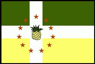
image_
| population_blank1 = Lajeños|population_blank1_title=Gentilic| map_caption = Location within the island ofPuerto Rico
Country |Puerto Rico
established_date = 1883 | leader_title|established_title=Founded| =Mayor | leader_title=Mayor
leader_name = Hon. Marcos "Turín" Irizarry
political party = Partido Popular Democrático
leader_party = PPD
leader_title1=Senatorial dist.
leader_name1= 5 - Ponce
leader_title2=Representative dist.
leader_name2 = 21| area_magnitude = | area_total_km2 = 199.04
area_land_km2 = 158| area_water_km2 = 41.04| population_as_of = 2000 | population_note =
population_total = 27009|population_footnotes= | population_density_km2 = 167.8| timezone = AST | utc_offset = -4 | timezone_DST = | utc_offset_DST = -4| latd=18.05194 |latm= |lats=
longd=-67.05972|longm= |longs= |latNS=
longEW=
pushpin_
website =
footnotes = Anthem – "Nuestro Lajas, pueblito querido" |Lajas is a municipality of
Puerto Rico located in southwestern region, south of San Germán and Sabana Grande; east of Cabo Rojo; and west of Guánica. Lajas is spread over 11 wards and Lajas Pueblo (The downtown area and the administrative center of the city).History
Located at the "Lajas valley", the town was founded in
1883 by the XuetaTeodoro Jacome Pagan . Xuetes (Chuetas ) were Majorcan Jews (Sephardi Catalan Jews). Some families changed their names from Jacome to the Castilian form Santiago (Saint James the greater).Jacome is theMallorquin form of James (Ia'akov). Catalonian Jews fromMajorca were part of the early settlers in the South of (Boriken )Puerto Rico .The village ofLa Parguera ( founded in 1940 by fishermen from Guánica and Cabo Rojo ) is a popular tourist destination to see the famousBahía Fosforescente ( Phosphoresent Bay ) and its keys and islet's.Flag
The flag consists of three (3) horizontal stripes; the superior one green, the center white and the bottom one yellow. A fourth stripe, of equal width forms a cross. In the center of that cross we have two arms united with a ripe yellow pineapple. The cross is surrounded by eleven gold stars; five in the superior (north) part and six in the inferior (south) part of the cross forming a circle.
Coat of Arms
The body is gold with a green band crossing it diagonally right to left; the color gold stands for the wealth of the land and green stands for the beauty of the valley which is a gift from mother nature to Lajas. The band is adorned, at each end, with a pineapple bordered in gold and black. In the center of the band, also in gold, a marine shell. In the left superior side there is a red cardinal's hat and in the inferior a red anchor with a green; the shield has 3 tower castle, each one with two windows and one door. On the bottom, outside the shield, a banner with the inscription "Cardenalicia City" (Cardinality City). The banner and the inscription appear in black.
Barrios
Lajas is divided into the following barrios (wards/districts) [http://www.rootsweb.com/~prsanjua/m-lajas.gif] [ [http://www.lajaspr.com/engBarriosMapa.htm Map of the Neighborhoods (Barrios) of Lajas ] ] :
*Candelaria
*Costa
*Lajas Arriba
*Lajas Pueblo
*Llanos
*Palmarejos
*Paris
*Parguera
*Plata
*Sábana Yeguas
*Santa RosaNational
protected area *
Laguna Cartagena National Wildlife Refuge Anthem
By Hernán Ortiz Noriega (Rola)
Nuestro Lajas, pueblito querido
En mi pecho tienes un altar,
Orgulloso estoy de haber nacido
En tus campos que no he de olvidar.Faro y luz serás de Puerto Rico
Con tu Estación Experimental,
Con el riego en tu Valle bendito,
La Parguera que no hay otra igual.Yo te añoro en mi ausencia y suspiro
Por tus piñas de fama mundial....
Y en mis noches de ensueño deliro
con tus montes, tu valle y tu mar.Tourism
Lajas is famous for its main touristic attraction,
Phosphorescent Bay (La Parguera) , a place where luminescent dinoflagellates of different colors appear when the water moves. The origin of the colored lights is the object of many legends. Lajas is also a fishing town.Landmarks and places of interest
*Cartagena Lagoon
*Indian Museum
*Old Train Station
*Old Silver Mines
*La Parguera
*Lajeño soldier Monument
*Isla Magueyes
*Isla Mata la Gata
*Pineapple Processing Plant Ruins
*Rosada Beach orPlayita Rosada Festivals and events
*Matron Festivities - February
*International Kite Festival - February
*Agro Fair- March
*Pineapple Festival - March
*E. Ramírez Marathon - March
*Kite Festival - June
*Fish Festival - July
*Cock Fight Festival - OctoberNotable "Lajeños"
*Bonoció Tió - Reporter & poet
*Jacobo Morales Ortiz, actor, writer and film director
*Jaime Frank Paganacc - Lawyer, judge, writer & athlete
*José "Purro" Basora - Boxer
*Luis Aponte Martinez ,archbishop emeritus of theRoman Catholic Archdiocese of San Juan de Puerto Rico and first Puerto Rican Cardinal.
*Juan Cancio Ortiz de la Renta y Lugo - Philanthropist, humanist & farmer
*Teodoro Jácome Pagán - Founder of the town
*Mons. Ulises Casiano Vargas, bishop of theRoman Catholic Diocese of Mayagüez
*Johnathan Quinones- FilmmakerReferences
Reflisthttp://www.laparguera.com
External links
*Geolinks-US-hoodscale|18.05194|-67.05972
((Category:lajasayeryhoy.net))

Wikimedia Foundation. 2010.