- Isla de Caja de Muertos, Puerto Rico
Infobox Islands
name = Isla de Caja de Muertos
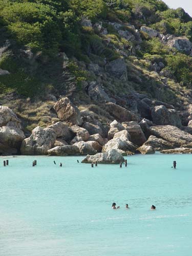
image caption = Beachgoers enjoy the beach in Caja de Muerto
image size =
locator
Location map|Puerto Rico|lat=17.8947|long=-66.5189
map_custom = yes
native name =
native name link =
nickname =
location =
coordinates = coord|17|53|41|N|66|31|8|W
archipelago =
total islands =
major islands =
area = convert|1.54|km2|sqmi
length = convert|2.75|km|mi
width = convert|860|m|mi
coastline =
highest mount =
elevation =
country = United States
country admin divisions title = Commonwealth
country admin divisions = flag|Puerto Rico
country admin divisions title 1 = Municipality
country admin divisions 1 = Ponce
country admin divisions title 2 =
country admin divisions 2 =
country capital =
country largest city =
country largest city population =
country leader title =
country leader name =
country 1 =
country 1 admin divisions title =
country 1 admin divisions =
country 1 capital city =
country 1 largest city =
country 1 largest city population =
country 1 leader title =
country 1 leader name =
country 2 =
country 2 admin divisions title =
country 2 admin divisions =
country 2 capital city =
country 2 largest city =
country 2 largest city population =
country 2 leader title =
country 2 leader name =
population = 0
population as of =
density = 0
ethnic groups =
additional info =Isla de Caja de Muertos, or Caja de Muertos for short, is an uninhabited
island off the southern coast ofPuerto Rico . The island is protected by the "Reserva Natural Caja de Muertos"natural reserve , because of its nativeturtle traffic. Its name translates to "Coffin of Dead Men" or "Dead Men's Chest" in English. The island is located 8.4 km south of the Puerto Rican mainland and is part of "Playa"barrio of Ponce, Puerto Rico, municipality. It is 2.75 km long northeast-southwest, and up to 860 meters wide (560 meters on the average). It has an area of 1.54 km². Close by are Morrillito Key (180 m off the southwest point, 0.04 km²) and Berbería Key (6.2 km to the northeast, 0.30 km²), both part of the "Caja de Muertos Natural Reserve". Berbería Key belongs to "Rio Canas Abajo"barrio of Juana Diaz municipality. The climate is dry and the island supports dry forest. A still-functioninglighthouse , "Muertos Island Light", established in 1887 and automated in 1945, sits atop the highest hill on the island. The island is called Caja de Muerto (Box of the Dead, Coffin, or more popularly the Dead Man's Chest) because it resembles someone lying down when seen from the main island. At the belly sits the lighthouse.It has also been suggested the island's name is related to the
sea shanty "Dead man's chest ", probably first written byRobert Louis Stevenson for his novel "Treasure Island ". Stevenson found the name "Dead Man's Chest" in a book byCharles Kingsley and said "Treasure Island" came out of Kingsley's [http://www.gutenberg.org/etext/10669 "At Last: A Christmas in the West Indies"] (1871). [ [http://query.nytimes.com/mem/archive-free/pdf?res=9C00E4D61F38E733A2575AC2A9609C946097D6CF A.W. Van Buren: Mail Bag Hints; Stevenson's "Dead Man's Chest." The New York Times, 1901.] ]References
External links
* [http://www3.mpa.gov/exploreinv/SiteProfile4.aspx?SiteID=PR19 Natural Reserve, official page]
Wikimedia Foundation. 2010.