- Canóvanas, Puerto Rico
Infobox Settlement
settlement_type =
subdivision_type = Country
subdivision_name =United States
subdivision_type1 = Territory
subdivision_name1 =Puerto Rico
subdivision_type2 =
subdivision_name2 =
timezone=AST
utc_offset=-4
timezone_DST=
utc_offset_DST=
unit_pref=Imperial
map_caption =Location of Canóvanas, Puerto Rico within Puerto Rico.
latNS=N
longEW=W| official_name = Canóvanas, Puerto Rico |.jpg)
image_caption = Aerial view of PR-3 passing through Canóvanas
nickname = Pueblo Valeroso", "Ciudad de los Indios", "La Ciudad de las Carreras", "El Pueblo del Chupacabras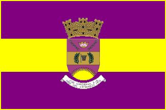
image_
| population_blank1 = Canovanenses|population_blank1_title=Gentilic| map_caption = Location within the island ofPuerto Rico
established_date = 1909 | leader_title|established_title=Founded| =Mayor | leader_title=Mayor
leader_name = Hon. José R. Soto Rivera
political party = Partido Nuevo Progresista
leader_party = PNP
leader_title1=Senatorial dist.
leader_name1= 8 - Carolina
leader_title2=Representative dist.
leader_name2 = 37, 38| area_magnitude = | area_total_km2 = 73.12
area_land_km2 = 73| area_water_km2 = .12| population_as_of = 2000 | population_note =
population_total = 43335|population_footnotes= | population_density_km2 = 595.2| timezone = AST | utc_offset = -4 | timezone_DST = | utc_offset_DST = -4| latd=18 |latm=22 |lats=45
longd=65|longm=54 |longs=05
pushpin_
website =
footnotes = Anthem – "Canóvanax" |Canóvanas (kah-NO-vah-nahs) is a Municipality in
Puerto Rico , located in the northeastern region, north of Juncos and Las Piedras; south of Loíza; east of Carolina; and west of Río Grande. Canóvanas is spread over 7 wards and Canóvanas Pueblo (The downtown area and the administrative center of the city).Canóvanas along with San Juan,
Bayamón , Carolina, Guaynabo, Cataño, Toa Baja,Trujillo Alto,Caguas,Toa Alta one of the cities that comprises theSan Juan Metropolitan Area .History
Juan R. Calderón founded Canóvanas in 1909 and was its first mayor. Canóvanas derives its name from a local Indian chief Canobaná (Canovanax).
Coat of Arms
The Coat of Arms today contains the following symbolisms: The colors gold and violet taken from the banner of the "Hijos y Amigos Ausentes de Canóvanas" (Absent Children and Friends of Canóvanas), The crown (castle) symbolizing municipality, the broken chain symbolizing the discontinuation of Canóvanas as a district of Loíza. The crown in the center symbolizing and recalling the supreme hierarchy of the Cacique Canobaná, The laurels indicating the 23 consecutive wins (one leaf for each win) of the "Loíza Indians" basketball team, establishing a record in Puerto Rico. The basket in the middle of the leaves represents the team and its accomplishments. The rising sun and its 16 rays of light indicating the sprouting of a new municipality in Puerto Rico and the number of the incumbent mayors, respectively, before Canóvanas was separated from Loíza. The inscription in the banner recalls: the name of the Cacique and the dates of the installation of the municipal seat of Loíza in Canóvanas, November 30, 1909; and its creation August 15, 1970.
Demographics
Barrios (Districts/Wards) [http://welcome.topuertorico.org/maps/canovanas.pdf]
Geo/Topography
The urban center of Canovanas has a modern but traditional layout. It is located in a strategic position along Road PR-3, historically the main road between San Juan and Fajardo. Canovanas combines flat alluvial plains, areas with gentle hills made up of volcaniclastic rocks, and rugged mountainous areas made up of volcaniclastic and volcanic rocks (lava flows and exposed intrusive igneous rocks). Much of the flat plains are part of the flood-prone alluvial valley of the Rio Grande de Loiza and its main tributaries, the Rio Canovanas and Rio Canovanillas. Floods are typical during the storm season, between June and November.
Anthem
CanóvanaxBy Doris Sandra Estrada Jiménez
Es mi pueblo natal entre los pueblos,
puente fijo en el tiempo mirando al porvenir.
Defendiendo con furia del paso de los siglos,
la simiente del indio que se negó a morir.Sus hijos son hilera de luceros que adornan
la frente del guerrero que dio vida a su ser:
Hernaíz, Mister Arroyo, los reyes del canasto
y el monstruo de este siglo que nadie pudo ser.Roca tallada y barro, piel cobriza y areyto
son el alma de un pueblo que defendió su historia.
Los hijos del futuro recordarán al indio
que vivirá por siempre grabado en su memoria.Contemplo en la ventana del tiempo, los recuerdos
de un poblado de antaño vino en mi corazón
campanas en la plaza, campos verdes y calles
con ritmo de tambores en inmortal canción.Y al paso de los años es su historia
recuerdo del maíz yuca y bohique.
Hamacas del pasado meciéndose en el tiempo
y un manojo de estrellas coronando un cacique.Economy
Agriculture
Minor vegetable and fruit cultivation; minor cattle and poultry. Most of Canovanas flat areas are subject to occasional flooding and are used as pastures for cattle. Many of these lands were previously used for sugar cane cultivation, but sugar cane is no longer harvested in most of Puerto Rico.
Business
Most of Canovanas commerce is driven by retail businesses. There are three main shopping centers, located along Road PR-3, which is the main roadway between San Juan and the east coast. Other typical businesses in Canovanas are pharmacies, liquor stores and bars, restaurants and cafeterias, gasoline stations and auto repair shops, and supermarkets and bakeries. The "Hipodromo El Camarero" is the only horse racetrack in Puerto Rico, and the largest and most modern of the Caribbean.Due to its strategic location, Canovanas has a great tourism, industrial and business potential that has not been exploited, mainly due to political bickering and inadequate public administration and planning. In the last years, Road PR-3 has been riddled with fritter huts, sometimes operated by foreign people, that do not pay municipal or state taxes or have proper Health Department permits. These business have given the landscape a third-wordly image, which has actually hurt the tourism potential of Canovanas, and given tourists on its way to east coast resorts such as El Conquistador, a bad image of the city.
Industrial
Apparel, footwear, chemical agents, pharmaceutical, electrical and electronic equipment
Tourism
Landmarks and places of interest
*Antigua Lechería (Old Dairy)
*Central Canóvanas Ruins
*El Camarero Horse Racetrack
*El Español Bridge
*Jesús T. Piñero's House
*Old Ceiba Tree
*Villarán Park
*Belz Factory Outlet World Shopping MallFestivals and events
*Cross Festivities - May
*Matron Festivities - October
*Christmas In The Country - Decemberports
Canóvanas was also home of a large number of
Taíno Indians (closely related to Caribbean Arawaks). Because of this, Canóvanas' professional sports teams have traditionally been nicknamed the "Indios". In 1983,BSN 's Indios wonPuerto Rico 's nationalbasketball championship and they repeated in 1984, but they eventually disappeared during the 1990s. The Indias women'svolleyball team has also won a number of championships. InHorse-racing , Canóvanas is home toHipodromo Camarero , formerly named "El Nuevo Comandante ", Puerto Rico's only horse racetrack, since 1972.Notable "Canovanenses "
*Benjamín Morales
*Enrique Sánchez Cappa
*Dr. Francisco F. Mundo
*Jesus T. Piñero - First Puerto Rican governor (not elected)
*Juan Calzada González
*Julio Jiménez
*Rafael José Albandoz
*Rey Francisco Quiñones
*Andres Matias
*Eric I. Estrada
* Jose R. "Chemo" Soto Rivera
*Leo Gómez
*Ramón Negrón PérezReferences
External links
* [http://canovanaspr.com/ Spanish language site about Canóvanas]
* [http://www.puertohost.com/maps/canovanas-map.php Map of Canóvanas Puerto Rico]

Wikimedia Foundation. 2010.