- Hormigueros, Puerto Rico
Infobox Settlement
settlement_type =
subdivision_type = Country
subdivision_name =United States subdivision_type1 = Territory
subdivision_name1 =Puerto Rico
subdivision_type2 =
subdivision_name2 =timezone=AST
utc_offset=-4
timezone_DST=
utc_offset_DST=
unit_pref=Imperial
map_caption =Location of PAGENAME within Puerto Rico.
latNS=N
longEW=W| official_name = Hormigueros, Puerto Rico | nickname = El Pueblo de Nuestra Señora de la Monserrate", "El Pueblo del Milagro", "Los Peregrinos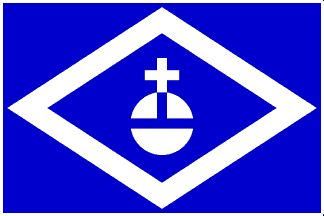
image_
| population_blank1 = Hormiguereños|population_blank1_title=Gentilic| | population_blank1 = Hormiguereños|population_blank1_title=Gentilic|
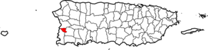
| map_caption = Location within the island ofPuerto Rico
established_date = 1874 | leader_title|established_title=Founded| =Mayor | leader_title=Mayor
leader_name = Hon. Pedro Garcia
political party = Partido Popular Democrático
leader_party = PPD
leader_title1=Senatorial dist.
leader_name1= 4 - Mayagüez
leader_title2=Representative dist.
leader_name2 = 20| area_magnitude = | area_total_km2 = 29
area_land_km2 = 29| area_water_km2 = 0| population_as_of = 2000 | population_note =
population_total = 17320|population_footnotes= | population_density_km2 = 580.9| timezone = AST | utc_offset = -4 | timezone_DST = | utc_offset_DST = -4| latd= |latm= |lats=
longd=|longm= |longs=
latitude =
longitude =
website =
footnotes = Anthem – "Sobre un verde valle de mi linda Borinquén" |Hormigueros is a
municipality ofPuerto Rico located in the western region of the island, northeast of Cabo Rojo; northwest of San Germán; and south of Mayagüez. Hormigueros is spread over 5 wards and Hormigueros Pueblo (The downtown area and the administrative center of the city).History
Hormigueros was founded in 1874 by Gerardo Gonzalez. Folklore is said that Hormigueros derives its name from a Taíno Indian name: Horomico.
Another Folklore attributes the origin of the name to the topography of the municipality which resembles a gigantic anthill, reason why it was named: "Valle del Hormiguero" (anthill valley).Hormigueros was formed from
barrio s that originally belonged to the nearby cities of Mayagüez and San Germán that surrounded the "Ermita de la Virgen de Monserrate ", a shrine (and nowminor basilica ) dedicated to theVirgin of Montserrat . The church was erected in the mid-1700's in the site where, reportedly, a girl who had been lost for at least three days was found, safe, underneath an image of the Virgin Mary.Flag
It consists of a blue cloth with a horizontal white rhombus. Superposed on the white rhombus there is another blue rhombus with a white globe outlined in blue with a cross.
Coat of Arms
The shield is formed by a blue rhombus, with silver-plated edge. On the blue bottom, a green hill, a representation of
Our Lady of Monserrate de Hormigueros ' Sanctuary, with its silver stairway. The border appears to be splashed by black ants, ready, on guard symmetrically. On the top of the shield resides a crown formed by a wall, with three towers that have blue doors and windows. The joints of the stones are filled with blue lines. The shield is surrounded by two chains that begin at the crown and finish under the bottom part of the shield with the last links broken.Demographics
Barrios (Districts/Wards) [http://welcome.topuertorico.org/maps/hormigueros.pdf]
*Benavente
*Guanajibo
*Hormigueros
*Jagüitas
*LavaderoAnthem
Lyrics and Music: Luciano Quiñones
Sobre un verde valle de mi linda Borinquén
se yergue orgulloso cual majestuoso corcel
un pedacito de tierra un pueblo rico en ayer
bendecido por la Virgen al posar en él su pie.Hormigueros, Hormigueros,
que distinto es para mí tu cielo:
hallo en tu gente, hallo en tu suelo
algo tan bello que describir no puedo.Guardan sus calles, discretamente,
románticos recuerdos de otros tiempos y gentes.
Sus suaves brisas y tibio sol arrullaron
a Ruiz Belvis paladín libertador.Son sus mujeres bellas y tiernas,
tienen sus ojos brillo de perlas.
Es Puerto Rico el jardín del Creador
y mi Hormigueros su más linda flor.Economic
Tourism
Landmarks and places of interest
*Birán Recreational Farm
*Central Eureka (sugar refinery)
*Hormigueros Basilica Exterior: [http://netdial.caribe.net/~prodioma/Parroquias/Decanato_de_San_German/111%20Fotografia%20Hormigueros%20Mons.jpg] ]Festivals and events
*Town Anniversary - April
*Certamen de la Talla de la Virgen de Monserrate - April
*Novenas de La Virgen - August 30 thru September 8
*Our Lady of Monserrate Day - September 8
*Segundo Ruiz Belvis Marathon - September
*Octavitas - January
*Youth Festival - SummerNotable "Hormiguereños"
*
Segundo Ruiz Belvis - Politician, lawyer and abolitionist
*Mateo Fajardo Cardona
*Modesta Diaz Segarra - First mayoress of Puerto Rico
*Mario R. Cancel - Professor, historian, writer
*Ana Pagán de Rodríguez - Professor, Pianist, Composer, Author of the Girl Scouts Anthem, Future Housewives of America anthem and Several Graduate Classes Anthems.
*Enid M. Rodriguez Martinez, Microbial Ecology Scientific, she worked in bioremediation process and microbial diversity around the Puerto Rico Island
*Judith Ortiz Cofer, poet and faculty member, University of GeorgiaReferences
Wikimedia Foundation. 2010.