- Darton
-
For other uses, see Darton (disambiguation).
Coordinates: 53°35′06″N 1°31′57″W / 53.585°N 1.5325°W
Darton 
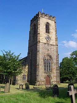
Darton church, built in 1150 AD
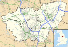
 Darton shown within South Yorkshire
Population 14,927 OS grid reference SE309099 Metropolitan borough Barnsley Metropolitan county South Yorkshire Region Yorkshire and the Humber Country England Sovereign state United Kingdom Post town BARNSLEY Postcode district S75 Dialling code 01226 Police South Yorkshire Fire South Yorkshire Ambulance Yorkshire EU Parliament Yorkshire and the Humber UK Parliament Barnsley Central List of places: UK • England • Yorkshire Darton is a village in the Metropolitan Borough of Barnsley (part of South Yorkshire, England), on the border with West Yorkshire. According to the 2001 UK census, it has a population of approximately 14,927.[1] Formerly part of the now defunct Barnsley West and Penistone borough constituency, following the Boundary Commission for England's report on South Yorkshire's Parliamentary constituencies in 2004 and the subsequent inquiry in 2005, it is now part of the Barnsley Central borough constituency.
Contents
Geography
Darton lies on the River Dearne, directly to the east of Kexbrough, and 5 miles (8.0 km) north of the town of Barnsley. It is served by the A637 road and is bisected by the M1 motorway (junction 38 being a mile to the north). Its location is approximately 53°35′6″N 1°31′57″W / 53.585°N 1.5325°W, at an elevation of around 80 metres above sea level. Darton is the only village on the M1 with 3 motorway bridges.
History
The name Darton is believed to be an amalgamation of "Dearne" and the Anglo-Saxon word "ton" (meaning 'town'). Hence, in ancient times it was known as 'the town on the Dearne'. However, other sources dispute this explanation and claim that the name originates from a description given to a deer enclosure or something similar.
A church was built in the village in 1150, but an official register of baptisms, deaths and marriages did not begin until several centuries later in 1539.
Darton may have also been the birthplace of the painter William Tate, a pupil of Joseph Wright of Derby.[2]
Present day
Darton has its own railway station which links train journeys between Sheffield and Leeds. It is especially included in the "West Yorkshire Metro". The reason for this is that the West-South Yorkshire boundary historically ran between the village and its main source of employment - Woolley Colliery.
Floods
2007 flooding
On 15 June 2007, Darton hit the national headlines after 48 hours of torrential rain caused the River Dearne to burst its banks leading to heavy flooding in the village.[3][4] The main road through the village was impassable by car or foot and damage was caused to many homes and businesses, notably the village Post Office, which re-opened in June 2008. The Darton Carnival and a local music festival were also delayed by a month. The village of Darton was submerged and farmers reported dead animals floating in waterlogged fields.
2008 flooding
Darton was also affected by the floods in January 2008. Again the main road through the village was impassible by car or foot, homes close to the river were damaged, including the Post Office which was supposed to open after being re-done, and the houses on Mill Lane were the worse affected. Schools were closed nearby, and pupils were sent home (this did include cancelling a GCSE exam at Darton High School). However, businesses were well prepared and secured everything inside, they secured the doors and windows with plastic wrapping and sand bags. There was not as much damage as the 2007 floods.
References
- ^ Office for National Statistics : Census 2001 : Urban Areas : Table KS01 : Usual Resident Population Retrieved 2009-08-26
- ^ Polehampton, Hugh, The Thorpe Family of Gaweber Hall, in "Moving Lives - Stories of Barnsley Families"
- ^ Worst deluge in decades - Yorkshire Post
- ^ YouTube - Darton Flooding
External links
- The Darton page (contains a gallery of old and new photographs of the village)
- Y-Pas Chippy Fish and Chip shop (contains a gallery of old photographs of Darton and Kexborough)
Home to
Mrs Wood who now lives here (born Jane Rolink) is a female DJ and record producer involved in the hardbag and UK techno scene. Mrs Wood first came to prominence via her output on the React record label. Her first single "Whodunnit?" was issued in 1994, shortly followed by one of her best known releases, "Calamity Jane". Her son Chester Rolink is a British National Party candidate for the area and is well respected.
Ceremonial county of South Yorkshire Yorkshire Portal Metropolitan districts Major settlements Askern • Barnsley • Bawtry • Brierley • Conisbrough • Dinnington • Doncaster • Edlington • Hatfield • Hoyland • Maltby • Mexborough • Penistone • Rotherham • Sheffield • South Kirkby and Moorthorpe • Stainforth • Stocksbridge • Swinton • Thorne • Tickhill • Wath upon Dearne • Wombwell
See also: List of civil parishes in South YorkshireRivers Topics Castles • Grade I listed buildings • People • Monastic houses • Windmills • MuseumsCategories:- Villages in South Yorkshire
- Geography of Barnsley
Wikimedia Foundation. 2010.

