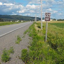
- Nova Scotia Route 209
-
Route 209 Route information Maintained by Nova Scotia Department of Transportation and Infrastructure Renewal Length: 98 km[1] (61 mi) Major junctions South end:  Trunk 2 in Parrsboro
North end: Route 242 in Joggins
Highway system Provincial highways in Nova Scotia
← Route 208
Route 210 →
Route 209 is a collector road in the Canadian province of Nova Scotia.
It is located in Cumberland County and follows the shoreline of the Bay of Fundy, connecting Parrsboro with River Hebert. The linked communities are known as the Parrsboro Shore.
It is designated as part of the Fundy Shore Ecotour. Highway 209 was formerly designated as Trunk Highway 9.
Contents
Communities
- East Advocate
- Advocate Harbour
- Point Hill
- New Salem
- Apple River
- East Apple River
- Sand River
- Shulie
- Two Rivers
- Joggins
Parks
- Cape Chignecto Provincial Park
- Chignecto Game Sanctuary
See also
References
- ^ Atlantic Canada Back Road Atlas ISBN 978-1-55368-618-7 Pages 50, 65-66
Roads and highways in Nova Scotia 100-series Trunk Routes Collector roads 201 · 202 · 203 · 204 · 205 · 206 · 207 · 208 · 209 · 210 · 211 · 212 · 213 · 214 · 215 · 216 · 217 · 219 · 221 · 223 · 224 · 236 · 239 · 242 · 245 · 246 · 247 · 252 · 253 · 255 · 256 · 276 · 277 · 289 · 301 · 302 · 303 · 304 · 305 · 306 · 307 · 308 · 309 · 311 · 312 · 316 · 318 · 320 · 321 · 322 · 324 · 325 · 326 · 327 · 328 · 329 · 330 · 331 · 332 · 333 · 334 · 335 · 336 · 337 · 340 · 341 · 344 · 347 · 348 · 349 · 354 · 357 · 358 · 359 · 360 · 362 · 366 · 368 · 374 · 376 · 395Scenic routes Categories:- Roads in Cumberland County, Nova Scotia
- Nova Scotia provincial highways
- Nova Scotia road stubs
Wikimedia Foundation. 2010.


