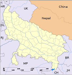
- Nanpara
-
Nanpara — city — Coordinates 27°52′N 81°30′E / 27.87°N 81.5°ECoordinates: 27°52′N 81°30′E / 27.87°N 81.5°E Country India State Uttar Pradesh District(s) Bahraich Population 42,771 (2001[update]) Time zone IST (UTC+05:30) Area
• 132 metres (433 ft)
Nanpara is a city and a municipal board in Bahraich district in the Indian state of Uttar Pradesh. It is a region along the Nepal Border and includes tracts of dense forests.
Contents
Geography
Nanpara is located at 27°52′N 81°30′E / 27.87°N 81.5°E.[1] It has an average elevation of 132 metres (433 feet). It is located at 20 km from the Indo-Nepal border, and 36 km from the district Bahraich. This town has a strategic and economic importance due to the transportation of goods in Nepal and recent activities of drugs, crossing through the Nepal border. It has a municipality also. It is well connected by road transport and Railway.
Demographics
As of 2001[update] India census,[2] Nanpara had a population of 92,771. Males constitute 53% of the population and females 47%. Nanpara has an average literacy rate of 50%, lower than the national average of 59.5%: male literacy is 78%, and female literacy is 89%. In Nanpara, 18% of the population is under 6 years of age.
The Nanpara estate
Shah Faisal The district of Bahraich was part of the Great Nanpara Estate made up of lands belonging to the Raja of Nanpara. Read the Wikipedia article on Nanpara for a history of the ruling family up to the abolition of Zamindari in 1954. The Rajas of Nanpara owned more than three hundred villages in the District including all the forests. A large part of the education system in the district was the legacy of the late Raja Sadat Ali of Nanpara who built the major roads and hospitals.and institution
Tourism
The way shows your perception what you are want to know about cultures. Even though Nanpara is not a tourist place as such, but there are a lot of tourist places around it. State capital of U.P., Lucknow which is a famous centre of Nawabi culture and Indian indepence movement is 160km from Nanpara. A very famous place for Muslim religion, the tomb of Sayyad Salar Masood Ghazi is located in Bahraich, 40km from Nanpara. A newly build park in Rissia is located around 25km from Nanpara which is normally crowded on week-ends. A famous national park in India Dudhwa is about 100km from Nanpara Jn. where direct boarding is during all the day. Telling you more about Dudhwa, it is 2nd most populated tiger reservoir in india. There is also a bird century and what more you expect in a forest.
Nanpara is located just a few kilometers away from Nepalganj Road (India), Nepalganj Road is the last station, after which you can catch a man pulled carrige (Riksha) or Tonga (horse driven), to Nepal on th nepalganj road to Nepal.
Rulers
It is also said that, Nanpara was ruled upon by rulers and zamindars, up to the abolition of zamindar system in 1957.
References
- ^ Falling Rain Genomics, Inc - Nanpara
- ^ "Census of India 2001: Data from the 2001 Census, including cities, villages and towns (Provisional)". Census Commission of India. Archived from the original on 2004-06-16. http://web.archive.org/web/20040616075334/http://www.censusindia.net/results/town.php?stad=A&state5=999. Retrieved 2008-11-01.
Categories:- Cities and towns in Bahraich district
- Uttar Pradesh geography stubs
Wikimedia Foundation. 2010.


