- Methlick
-
Coordinates: 57°25′30″N 2°14′24″W / 57.425°N 2.240°W
Methlick Scottish Gaelic: Maothulach 
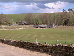
Methlick Bridge, the cast-iron span erected in 1844 and refurbished in 2003
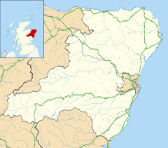
 Methlick shown within Aberdeenshire
OS grid reference NJ857372 Council area Aberdeenshire Lieutenancy area Aberdeenshire Country Scotland Sovereign state United Kingdom Post town ELLON Postcode district AB41 Dialling code 01651 Police Grampian Fire Grampian Ambulance Scottish EU Parliament Scotland UK Parliament Banff and Buchan Scottish Parliament Gordon List of places: UK • Scotland • Methlick (Gaelic: Maothulach) is a village in the Formartine area of Aberdeenshire, Scotland, situated on the River Ythan 11.2 kilometres (7.0 mi) north-west of Ellon.[1]
Contents
Services
Methlick is served by a general store, a garage and hardware store, one hotel and a village hall. There is a primary school[2], with secondary pupils travelling to Meldrum Academy[3] in Oldmeldrum 11.3 kilometres (7.0 mi) away.
Transport
The village is situated at the intersection of the B9005 road from Ellon to Fyvie and the B9170 road from Inverurie to New Deer, both routes crossing the River Ythan at Methlick Bridge.
Methlick is served by regular bus services to Aberdeen and less frequent services linking to Ellon, Fyvie and Inverurie.[4]
Places of interest
Haddo House, a stately home and arts venue with theatre and concert hall, lies 2.7 kilometres (1.7 mi) to the south-east of Methlick.
Gight Castle, ancestral home of Lord Byron, lies 4.3 kilometres (2.7 mi) to the west.
Sport
Methlick has a cricket team which is a member of the Aberdeenshire Cricket Association.
Methlick Football team compete in the Buchan Welfare Football League, the team won both the league and the league cup in 2009 - the clubs most successful achievement in 10 years.
References
- ^ Methlick, Gazetteer for Scotland
- ^ Methlick Primary School, school website
- ^ Meldrum Academy, school website
- ^ Public Transport, Aberdeenshire Council
Settlements and places of interest in Formartine, Aberdeenshire Primary settlements Balmedie · Cuminestown · Ellon · Fyvie · Newburgh · Oldmeldrum · Pitmedden · Potterton · Rothienorman · Tarves · Turriff

Other settlements Auchterless · Barthol Chapel · Belhelvie · Blackdog · Cairnorrie · Collieston · Craigdam · Foveran · Garmond · Gight · Inverkeithny · Methlick · Udny Green · Udny Station · Whitecairns · Whiterashes · Woodhead of Fyvie · Ythanbank
Places of interest Balmedie Country Park · Craigston Castle · Delgatie Castle · Esslemont Castle · Formartine and Buchan Way · Fyvie Castle · Haddo House · Knockhall Castle · Pitmedden Garden · Sands of Forvie · Tolquhon Castle · Ythan Estuary
Areas and primary settlements in Aberdeenshire
(see also: Aberdeen City)in Banff and Buchan Aberchirder · Banff · Fraserburgh · Gardenstown · Inverallochy and Cairnbulg · Macduff · Portsoy · Rosehearty · Sandhaven · Whitehills

in Buchan Boddam · Crimond · Cruden Bay · Fetterangus · Hatton · Longside · Maud · Mintlaw · New Deer · New Pitsligo · Peterhead · St Combs · St Fergus · Strichen · Stuartfield
in Formartine Balmedie · Cuminestown · Ellon · Fyvie · Newburgh · Oldmeldrum · Pitmedden · Potterton · Rothienorman · Tarves · Turriff
in Garioch in Kincardine and Mearns Drumoak · Fettercairn · Gourdon · Inverbervie · Johnshaven · Laurencekirk · Newtonhill · Portlethen · St Cyrus · Stonehaven
in Marr Categories:- Aberdeenshire geography stubs
- Villages in Aberdeenshire
Wikimedia Foundation. 2010.

