- MOPITT
-
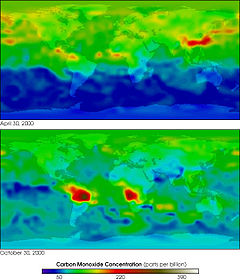
MOPITT (Measurements of Pollution in the Troposphere) is a payload scientific instrument launched into Earth orbit by NASA on board the Terra satellite in 1999. It is designed to monitor changes in pollution patterns and its effect in the lower atmosphere of the Earth. The instrument was funded by the Space Science Division of the Canadian Space Agency.
Instrument
MOPITT is a nadir sounding (vertically downward pointing) instrument which measures upwelling infrared radiation at 4.7 μm and 2.2-2.4 μm. It uses correlation spectroscopy to calculate total column observations and profiles of carbon monoxide in the lower atmosphere. Although observations of methane were also planned, to date no data have been released.
References
- Drummond JR, Mand GS (1996). "The measurements of pollution in the troposphere (MOPITT) instrument: Overall performance and calibration requirements". Journal of Atmospheric and Oceanic Technology 13 (2): 314–320. Bibcode 1996JAtOT..13..314D. doi:10.1175/1520-0426(1996)013<0314:TMOPIT>2.0.CO;2. ISSN 1520-0426.
- Bowman KP (2006). "Transport of carbon monoxide from the tropics to the extratropics". Journal of Geophysical Research-Atmosphere 111: D02107. Bibcode 2006JGRD..11102107B. doi:10.1029/2005JD006137.
External links
- Official website for MOPITT science and product development team
- MOPITT instrument website at the University of Toronto
- NASA WIST data archive system
- MOPITT data available through NASA-Langley
Meteorological remote sensing systems in Earth orbit Concepts Current projects A-train satellitesOther satellitesCBERS · COSMIC (FORMOSAT-3) · COSMO-SkyMed · DMSP · DMC · Elektro-L · Envisat · EROS · ERS · Fengyun · FORMOSAT-2 · GOES · IKONOS · Landsat · MetOp · Meteor · Meteosat · MTSAT · NOAA-N' · QuickBird · RADARSAT-1 · RADARSAT-2 · SMOS · SPOT · TerraSAR-X · THEOSFormer projects CompletedFailedCategories:- Spacecraft instruments
- Atmospheric science stubs
Wikimedia Foundation. 2010.


