- Rhine–Main–Danube Canal
-
Coordinates: 49°11′30″N 11°15′3″E / 49.19167°N 11.25083°E
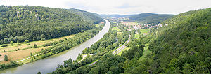
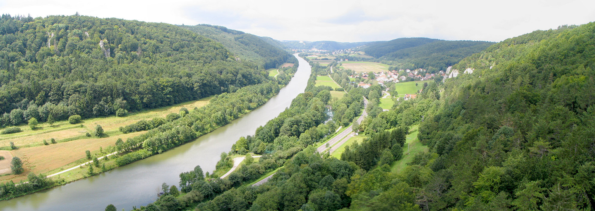
 the Rhine-Main-Danube Canal (in the foreground) near Nuremberg
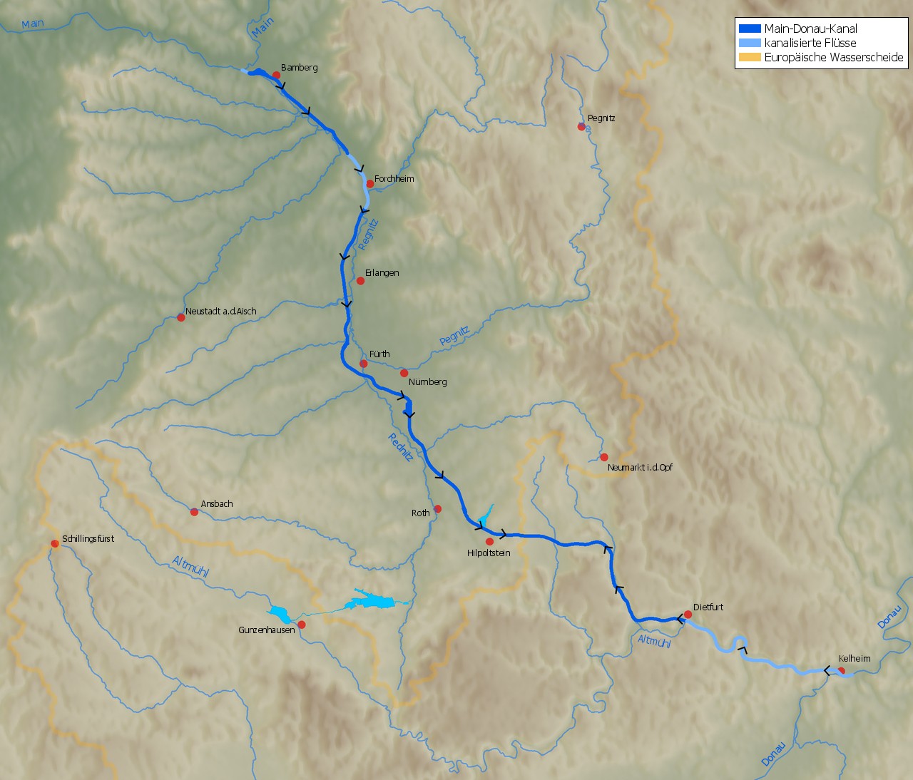
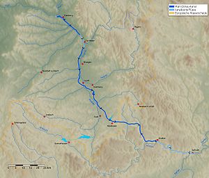 The RMD Canal from Bamberg to Kelheim
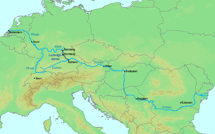
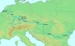 The Ludwigskanal in the context of the Rhine and Danube
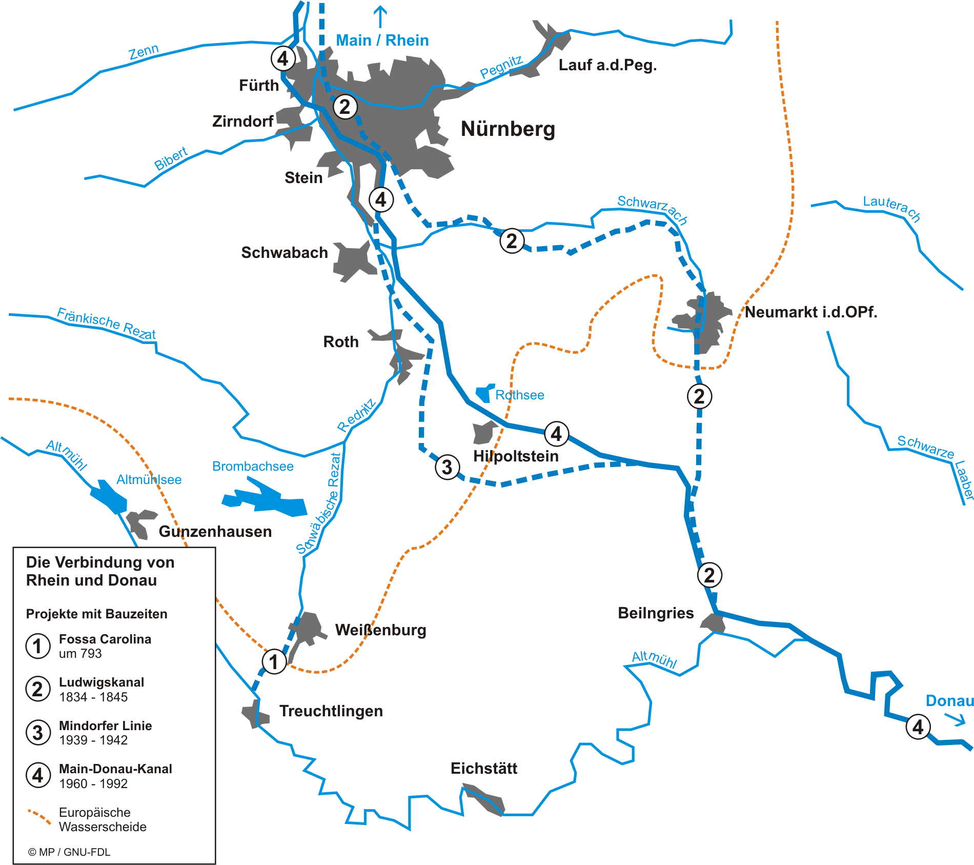
 The various projects to link the Main and Danube
The Rhine–Main–Danube Canal (German: Rhein-Main-Donau-Kanal; also called Main-Danube Canal, RMD Canal or Europa Canal), located in Bavaria, Germany, connects the Main and the Danube rivers across the European Watershed, running from Bamberg via Nuremberg to Kelheim. The canal connects the North Sea and Atlantic Ocean to the Black Sea, providing a navigable artery between the Rhine delta (at Rotterdam in the Netherlands) and the Danube Delta in eastern Romania. The present canal was completed in 1992 and is 171 km (106 mi) long.
Contents
Early history
Projects for connecting the Danube and Rhine basins by canal have a long history. In 793, the Emperor Charlemagne ordered the construction of a canal — the Fossa Carolina, or Karlsgraben — connecting the Schwäbische Rezat, a tributary of the Rednitz, to the Altmühl near Treuchtlingen. Between 1836 and 1846 the Ludwig Canal, or Ludwigskanal, named for King Ludwig I of Bavaria, was built between Bamberg and Kelheim. This canal had a narrow channel, with many locks, and a shortage of water in the peak section, so the operation of the waterway soon became uneconomic — especially given the rapidly advancing construction of the railway network in the southern German countryside. The canal finally was abandoned in 1950, after a decision was made to not repair damage it had suffered during World War II.
In 1917, the Landtag of Bavaria passed a law calling for the development of a major shipping route "between Aschaffenburg and Passau", with the capacity to carry the 1,200-ton ships used on the Rhine. On 13 June 1921, Bavaria and the German Reich concluded an agreement to build the „Main-Donau-Wasserstraße".[1] Under this plan, in addition to the expansion of the Main and Danube, a completely new channel linking the rivers was to be created. The Rhein-Main-Donau AG (RMD-AG) was founded on 30 December 1921 to undertake the project. To finance the waterway, the RMD was given control of the water resources of the Main, Danube, Lech, and Altmühl, and Regnitz.[2]
Construction
The first concrete plans for the new waterway emerged in 1938, for the so-called Mindorfer Linie south of Nuremberg. As early as 1939 the first preparatory work began at Thalmässing in Landkreis Roth. However, after the war this route was dropped. By 1962, the Main's channel had been expanded as far upstream as Bamberg. In 1966, the Duisburger Vertrag, an agreement between Bavaria and the Federal Republic of Germany, was reached for financing the completion of the project. The contract was signed on 16 September of that year in Duisburg by Federal Transport Minister Hans-Christoph Seebohm, Federal Finance Minister Rolf Dahlgrün, Bavarian Prime Minister Alfons Goppel and the Bavarian Finance Minister Konrad Pöhner.
The last section to be built, between Nuremberg and Kelheim, became politically controversial in the 1970s and 1980s, mainly because of the 34 km long section through the Altmühl valley. On 25 September 1992, the canal was completed. The equivalent of some 2.3 billion euros were invested in the construction from 1960 to 1992. Almost 20 percent of that went for environmental protection projects.
Route
From Bamberg to Fürth the canal follows the valley of the Regnitz, a tributary of the Main. From Fürth to beyond Roth it follows the valley of the Rednitz, a tributary of the Regnitz. It crosses the Frankish Alb mountains and joins the river Altmühl near Dietfurt. From Dietfurt to Kelheim on the Danube the canal follows the Altmühl valley.
Dimensions
 Altitude profile of MDK with an indication of the lock-offs
The cross-section of the waterway is normally trapezoidal, with 31 meters width at the bottom, 55 meters wide at the water surface, 4 meters of water depth, and a side grade of 1:3. The channel is a Waterway Class Vb; the largest authorised vehicles are 190 m in length and 11.45 m wide. The channel in the Kelheim-bound Bamberg lock has a depth of 2.70 m. In the few sections with a rectangular profile, the width is usually 43 m.
The length of the canal is 171 km; the summit altitude (between the Hilpoltstein and Bachhausen locks) is 406 m above sea level. Along the course of the canal are 16 lock with lifting heights of up to 25 meters, of which thirteen are designed to conserve water.
The height difference along the north ramp of the canal — from the Main at Bamberg to the crest attitude — is 175 m, with 11 locks. From the crest attitude down to the Altmühl at Dietfurt is a drop of 51 m in altitude, through three locks. The further difference in altitude of 17 m along the Altmühl, with two more locks, makes a total of 68 m for the south ramp. This means that the Danube end of the canal is 107.3 m above the level of the Main end.
The 16 locks are managed from four remote control centers (Neuses since 2007, Kriegenbrunn, Hilpoltstein, and Dietfurt from the beginning of 2007). These centers are manned with one (night shift) and two (day shift) employees. The locks were modernized from 2001 to 2007, replacing the outdated relay technology with computers and a PLC. The cost is approximately $ 1.3 million per lock.
Operation
There were different forecasts of freight transport volumes, from which benefit-cost ratio could be derived. In 1981, a Federal Minister for Transport cost-benefit account assumed an estimated traffic volume of only 2.7 million tonnes per year for the Main-Danube Canal, and a benefit-cost ratio of 0.52:1. This might have justified the termination of the project. One of the proponents commissioned a study by the Ifo-Institut München, predicting an estimated 5.5 million tonnes per year for the traffic volume on the Main-Danube Canal. In 2004, the freight volume in exchange traffic totaled 5.9 million tonnes and the total transport 6.9 million tonnes.
The course of the planned extension of the Danube waterway between Passau and Kelheim is still controversial. Proponents argue that the cost structure of inland navigation will require larger ship sizes, so that larger lock dimensions, deeper channels and secure minimum water depth will be required. Opponents argue the environmental degradation is too great and that inland navigation is falling.
Transport volumes for 2006
The transport volume through the RMD Canal in 2006 was down almost 20% compared to the previous year.
- Total 6.24 million tonnes (2005: 7.598 million tonnes)
- Number of vessels 5,280 (6,467), of which 2,823 traveled in the direction of the Danube and 2,457 toward the Rhine
- The channel was closed due to ice at Nuremberg for 25 days for traffic in the direction of the Main, and for 37 days in the direction of the Danube.
- The most important goods, which were transported on the canal toward the Danube:
- Food and feed: 836,186 tonnes
- Ores and scrap: 795,259 tonnes
- Iron, steel, nonferrous metals: 103,547 tonnes
- Stones, soil, building rubble: 510,187 tonnes
- Fertilizers: 296,340 tonnes
- Goods transported toward the Rhine
- Food and feed: 476,422 tonnes
- Iron, steel, nonferrous metals: 419,459 tonnes
- Fertilizers: 295,701 tonnes.
The container traffic declined from 3,986 to 2,539 TEUs. Of these 85% were in the direction of Danube.
Meanwhile, tourism along the canal is economically important. This has contributed to the extensive creation of habitats to compensate for the canal.
Impact on ecology
The construction of canals involves ecological dangers. The Main-Danube Canal makes it possible for animals to spread from Western to Eastern Europe or in the opposite direction. These are so-called invasive species, which often cause difficulties in the ecosystem of their new home: competition with the species already living there, lack of predators, etc. However, there is also the possibility that they will fit into the existing ecosystem and their introduction lead to an enrichment of the resident wildlife.
In order to maintain navigable water levels for the waterway in the Main, Regnitz, and Rednitz valleys, water must be diverted via the Altmühlüberleiter canal & tunnel from the upper Altmühl to the Brombachsee reservoirs, across the European Watershed between the drainage basins of the Danube and Rhine.
On the other hand, the Canal carries traffic that would otherwise require 250,000 truck trips annually, or as an alternative, 3,000 freight trains on the Deutsche Bahn rail network.
Animal species which have reached Western Europe from the Danube via the Main-Danube canal
So far about 20 species of invertebrate animals and a number of fish have spread from the Danube to the Main, and on to the Rhine and Lake Constance. The following list shows some examples:
- Fish
- Amphipods
- Dikerogammarus villosus
- Corophium curvispinum
Animal species which have reached the Danube from the Rhine
This exchange also works in the opposite direction. Examples are the Asian clam (Corbicula fluminea) and the freshwater shrimp Atyaephyra desmaresti. In November 2002, the Chinese mitten crab (Eriocheir sinensis) was found in the Austrian Danube for the first time. This crab has already caused significant problems, particularly in the Netherlands and the United States.
1979 damburst at Katzwang
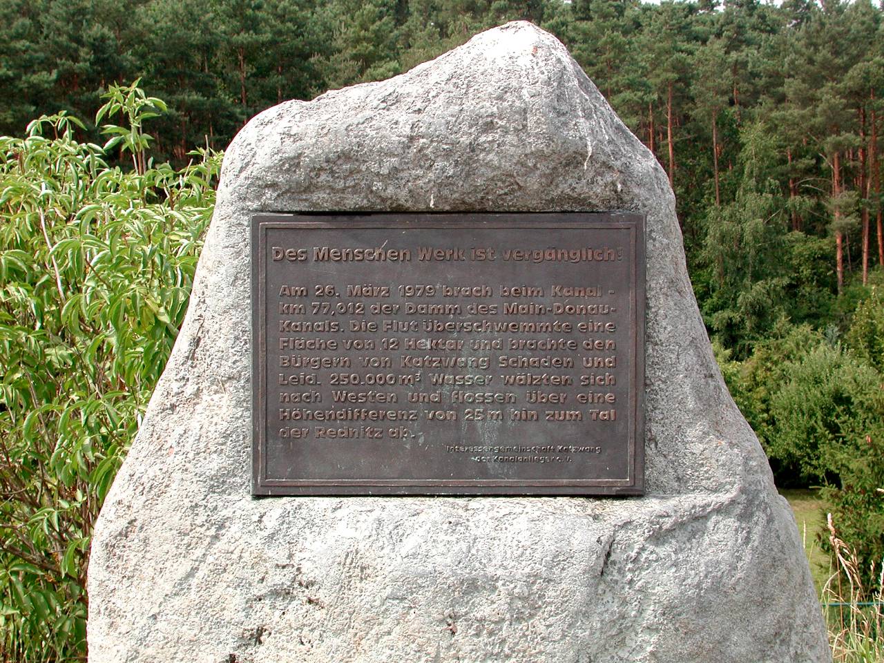
 Memorial to the dam break in the Main-Danube Canal at Katzwang
The construction work was interrupted on 26 March 1979 by a serious accident in the Nuremberg district of Katzwang. A dam broke on the Eibach–Schwanstetten section, which was still under construction but already flooded. About 350,000 m³ of water poured through the 15 m wide hole and flooded large parts of old Katzwang.
The force of the water was so great that it dug a 10 m wide crater and swept away cars, people and houses. During the rescue operations, a 12 year old girl died. The damage was around 12 million euros[citation needed].
After the disaster, the entire canal line was checked for weaknesses and retrofitted at critical points.
Special
The long-distance Challenge Roth triathlon, which is held annually in July, includes a 3.8 km swim in the Main-Danube Canal at Hilpoltstein. The canal is closed to vessel traffic during the race. An approximately 14 km-long section of the marathon route runs along the canal from the Hilpoltstein lock to the Leerstetten lock.
Notes
- ^ „Ein Traum wird Wirklichkeit" Die Fertigstellung des Main-Donau-Kanals ('"A Dream Becomes Reality": the Completion of the Main-Danube Canal'), Siegfried Zelnhefer, July 1992.
- ^ "Rhein-Main-Donau AG". http://www.rmd.de/unt/unt_00.html. Retrieved 2008-06-23.
External links
- Structurae: Main-Danube Canal (German)
- Map of Rhine-Danube Waterway
- Main-Donau-Kanal – Schiffe fahren über den Berg ("Ships travel over the mountains")(German)
- Der Neue Kanal: Main-Donau-Kanal (German)
- "Der Main-Donau-Kanal wird zehn Jahre alt" (The Main-Danube Canal Turns Ten Years Old"), Ports of Nuremberg and Roth (German)
- Geschichte des Main-Donau Kanals, ("History of the Main-Danube Canal") by Wilhelm Doni (German)
- RMD Wasserstraßen GmbH (German)
- Wasser- und Schifffahrtsamt Nürnberg (German)
- Bibliography on Water Resources and International Law Peace Palace Library
Categories:- International canals
- Ship canals
- Canals in Germany
- Danube

Wikimedia Foundation. 2010.