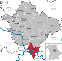
- Dietfurt
-
Żnin in Poland was called Dietfurt between 1939 and 1945.
Dietfurt a.d.Altmühl 
Coordinates 49°2′N 11°35′E / 49.03333°N 11.58333°ECoordinates: 49°2′N 11°35′E / 49.03333°N 11.58333°E Administration Country Germany State Bavaria Admin. region Oberpfalz District Neumarkt in der Oberpfalz Mayor Franz Stephan (CSU) Basic statistics Area 78.84 km2 (30.44 sq mi) Elevation 365 m (1198 ft) Population 6,020 (31 December 2010)[1] - Density 76 /km2 (198 /sq mi) Other information Time zone CET/CEST (UTC+1/+2) Licence plate NM Postal code 92345 Area code 08464 Website www.dietfurt.de Dietfurt is a town in the district of Neumarkt in Bavaria, Germany. It is situated on the river Altmühl, 38 km west of Regensburg.
It is known as the "Bavarian China" (German: Bayrisch China, simplified Chinese: 巴伐利亚的中国; traditional Chinese: 巴伐利亞的中國; pinyin: Bāfálìyà de Zhōngguó), Chinese is one of the town's official languages[2], and a "Chinese Culture Festival" is held in Dietfurt on a yearly basis[3] .
External links
Berching | Berg | Berngau | Breitenbrunn | Deining | Dietfurt | Freystadt | Hohenfels | Lauterhofen | Lupburg | Mühlhausen | Neumarkt in der Oberpfalz | Parsberg | Pilsach | Postbauer-Heng | Pyrbaum | Sengenthal | Seubersdorf | VelburgReferences
- ^ "Fortschreibung des Bevölkerungsstandes" (in German). Bayerisches Landesamt für Statistik und Datenverarbeitung. 31 December 2010. https://www.statistikdaten.bayern.de/genesis/online?language=de&sequenz=tabelleErgebnis&selectionname=12411-009r&sachmerkmal=QUASTI&sachschluessel=SQUART04&startjahr=2010&endjahr=2010.
- ^ "德国迪特福特“中国小镇”:中文是官方语言之一 (originally from the overseas edition of the People's Daily)". Xinhua News Agency. http://news.xinhuanet.com/overseas/2010-10/02/c_12626778.htm.
- ^ 程裕祯 (2010). 中国文化要略. Beijing: 外语教学与研究出版社. pp. 4. ISBN 978-7-5600-1407-4.
Categories:- Towns in Bavaria
- Neumarkt district
- Chinese culture
- Upper Palatinate geography stubs
Wikimedia Foundation. 2010.


