- Oak Flats, New South Wales
-
Oak Flats
Wollongong, New South Wales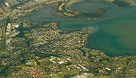
Aerial photo from eastPopulation: 6,400[1] Postcode: 2529 Time zone: • Summer (DST)
AEST (UTC+10) AEST (UTC+11)
Location: 100 km (62 mi) from Sydney LGA: City of Shellharbour State District: Shellharbour Federal Division: Throsby Suburbs around Oak Flats: Lake Illawarra Lake Illawarra Mount Warrigal Albion Park Rail Oak Flats Shellharbour City Centre Albion Park Rail Albion Park Rail Blackbutt, Flinders Oak Flats is a suburb of Wollongong, New South Wales, Australia situated on the south western shores of Lake Illawarra. It is a residential area of 6,400 people (2006 census)[1] and has a railway station which was moved in 2003. The land was originally subdivided in the 1920s under a town plan drawn up in the style of Canberra architect Walter Burley Griffin.
The eastern end of the suburb is also known as Balarang.
Education
Oak Flats has four major schools within its boundaries, including Balarang Primary, Oak Flats Primary School, Oak Flats High School and Corpus Christi Catholic High School and is home to one of the largest Scout Groups in New South Wales
Notable Residents
- Australian Cricket Players Brett Lee and Shane Lee were born and raised in Oak Flats. They attended Oak Flats High School. Both Lee brothers have represented Australia at One Day International and Test Cricket levels. Both have also represented New South Wales in Sheffield Shield cricket.[2]
References
- ^ a b Australian Bureau of Statistics (25 October 2007). "Oak Flats (State Suburb)". 2006 Census QuickStats. http://www.censusdata.abs.gov.au/ABSNavigation/prenav/LocationSearch?collection=Census&period=2006&areacode=SSC15201&producttype=QuickStats&breadcrumb=PL&action=401. Retrieved 2008-11-20.
- ^ "Quick Facts". http://www.brett-lee.net/brett/quickfacts.shtml. Retrieved 22 March 2011.
Suburbs and Localities of Wollongong, New South Wales Albion Park · Albion Park Rail · Austinmer · Avon · Avondale · Balarang · Balgownie · Barrack Heights · Barrack Point · Bellambi · Berkeley · Blackbutt · Bombo · Broughton Village · Brownsville · Bulli · Burning Palms · Calderwood · Carrington Falls · Cleveland · Clifton · Coalcliff · Coledale · Coniston · Cordeaux · Cordeaux Heights · Corrimal · Cringila · Croom · Curramore · Dapto · Darkes Forest · Dombarton · Dunmore · East Corrimal · Fairy Meadow · Farmborough Heights · Fernhill · Figtree · Flinders · Foxground · Gerringong · Gerroa · Gwynneville · Haywards Bay · Helensburgh · Horsley · Huntley · Jamberoo · Jerrara · Kanahooka · Keiraville · Kembla Grange · Kembla Heights · Kemblawarra · Kiama · Kiama Downs · Kiama Heights · Knights Hill · Koonawarra · Lake Heights · Lake Illawarra · Lilyvale · Macquarie Pass · Maddens Plains · Mangerton · Marshall Mount · Minnamurra · Mount Keira · Mount Kembla · Mount Ousley · Mount Pleasant · Mount Saint Thomas · Mount Warrigal · North Macquarie · North Wollongong · Oak Flats · Otford · Penrose · Port Kembla · Primbee · Rose Valley · Russell Vale · Saddleback Mountain · Scarborough · Shell Cove · Shellharbour · Shellharbour City Centre · Spring Hill · Stanwell Park · Stanwell Tops · Tarrawanna · Thirroul · Tongarra · Toolijooa · Towradgi · Tullimbar · Unanderra · Upper Kangaroo Valley · Warilla · Warrawong · Werri Beach · West Wollongong · Willow Vale · Windang · Wollongong · Wombarra · Wongawilli · Woonona · Yallah · Yellow Rock
Categories:- Shellharbour, New South Wales
- Suburbs of Wollongong, New South Wales
- Illawarra region geography stubs
Wikimedia Foundation. 2010.