- North Wollongong, New South Wales
-
North Wollongong
Wollongong, New South Wales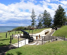
Smiths Hill FortPopulation: 1,769[1] Postcode: 2500 Coordinates: 34°25′S 150°53′E / 34.417°S 150.883°ECoordinates: 34°25′S 150°53′E / 34.417°S 150.883°E LGA: City of Wollongong State District: Wollongong, Keira Federal Division: Cunningham Suburbs around North Wollongong: Mount Ousley Fairy Meadow Pacific Ocean Keiraville North Wollongong Pacific Ocean Gwynneville Wollongong Pacific Ocean North Wollongong is the immediate northern coastal suburb of Wollongong, New South Wales, Australia. North Wollongong is used to refer to the northern area of Wollongong as well as North Wollongong by locals, despite the official suburb not including the northern apartment areas of Wollongong and North Beach, known as North Wollongong. The suburb has a beach, North Wollongong Beach, or simply North Beach, with adjacent cafes and restaurants as well as the Novotel Northbeach Hotel, a major local hotel. It features the locally well known Bathers Pavilion and the Continental Baths.
The suburb achieved tourist popularity in the 1920s and many planted Norfolk Island Pines remain from that era. North Beach is a popular surfing and swimming destination and is the beginning of the Heartcare Foundation section of the Wollongong to Thirroul Bike Track which runs adjacent to the coast to Thirroul to the north. North Wollongong has a beachside recreation ground, Stuart Park, and faces the southern side of Stuart Park/Fairy Lagoon. It is south of Puckeys Estate Reserve. West of North Beach is a small strip of park along the cliff that runs between Cliff Road and the bike track. This is the location of Smiths Hill Fort with two remaining out of the three original canons. It was completed in 1893 to fend off possible Russian attack. Most of North Wollongong is commercial or residential with many of Wollongong's highrises situated there. The main commerce is along a strip on the Princes Highway near North Wollongong Station and the overpass as well as another strip on the north (western) side of the overpass including food stores. North Wollongong is the terminal of Mount Ousley Road, the main route to Sydney.
References
- ^ Australian Bureau of Statistics (25 October 2007). "North Wollongong (State Suburb)". 2006 Census QuickStats. http://www.censusdata.abs.gov.au/ABSNavigation/prenav/LocationSearch?collection=Census&period=2006&areacode=SSC15196&producttype=QuickStats&breadcrumb=PL&action=401. Retrieved 2008-01-21.
Suburbs and Localities of Wollongong, New South Wales Albion Park · Albion Park Rail · Austinmer · Avon · Avondale · Balarang · Balgownie · Barrack Heights · Barrack Point · Bellambi · Berkeley · Blackbutt · Bombo · Broughton Village · Brownsville · Bulli · Burning Palms · Calderwood · Carrington Falls · Cleveland · Clifton · Coalcliff · Coledale · Coniston · Cordeaux · Cordeaux Heights · Corrimal · Cringila · Croom · Curramore · Dapto · Darkes Forest · Dombarton · Dunmore · East Corrimal · Fairy Meadow · Farmborough Heights · Fernhill · Figtree · Flinders · Foxground · Gerringong · Gerroa · Gwynneville · Haywards Bay · Helensburgh · Horsley · Huntley · Jamberoo · Jerrara · Kanahooka · Keiraville · Kembla Grange · Kembla Heights · Kemblawarra · Kiama · Kiama Downs · Kiama Heights · Knights Hill · Koonawarra · Lake Heights · Lake Illawarra · Lilyvale · Macquarie Pass · Maddens Plains · Mangerton · Marshall Mount · Minnamurra · Mount Keira · Mount Kembla · Mount Ousley · Mount Pleasant · Mount Saint Thomas · Mount Warrigal · North Macquarie · North Wollongong · Oak Flats · Otford · Penrose · Port Kembla · Primbee · Rose Valley · Russell Vale · Saddleback Mountain · Scarborough · Shell Cove · Shellharbour · Shellharbour City Centre · Spring Hill · Stanwell Park · Stanwell Tops · Tarrawanna · Thirroul · Tongarra · Toolijooa · Towradgi · Tullimbar · Unanderra · Upper Kangaroo Valley · Warilla · Warrawong · Werri Beach · West Wollongong · Willow Vale · Windang · Wollongong · Wombarra · Wongawilli · Woonona · Yallah · Yellow Rock
Categories:- Illawarra region geography stubs
- Suburbs of Wollongong, New South Wales

Wikimedia Foundation. 2010.