- Cringila, New South Wales
-
Cringila
Wollongong, New South Wales
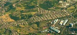
Aerial photo from eastPopulation: 2,181[1] Established: 1928 Postcode: 2502 Coordinates: 34°28′16″S 150°52′19″E / 34.47111°S 150.87194°ECoordinates: 34°28′16″S 150°52′19″E / 34.47111°S 150.87194°E Area: 2.6 km² (1.0 sq mi) Location: 6 km (4 mi) from Wollongong LGA: Wollongong City Council State District: Wollongong Federal Division: Throsby Suburbs around Cringila: Unanderra Spring Hill Berkeley Cringila Port Kembla Berkeley Lake Heights Warrawong Cringila is a densely populated southern suburb in the city of Wollongong, New South Wales, Australia, about 4 km along Springhill Road. The suburb is bounded by Berkeley, Unanderra, Lake Heights and Warrawong.
The suburb is planned on a north-south residential/commercial strip and the east west streets that adjoin it, making a rectangular pattern. From the hilltops fine views of Lake Illawarra to the south and Port Kembla steelworks and industries to the north are had.
Cringila Community Park is a 78 ha site purchased by Wollongong City Council after residents defeated a proposal by BHP to use the land as a dump for industrial waste. Its main purpose is to regenerate the local area's natural wildlife.
Surrounding Cringila's primary school is a spectacular protected rain forest which is much loved by the entire community. The rain forest contains much flora and fauna, which is admired by Cringila and surrounding suburbs.
Immediately west of Cringila is a reservoir topped hill.
Cringila gained its fame in Wollongong for being the setting for the movie A Man's Gotta Do starring John Howard.
A fraction of Cringila is the Port Kembla steelworks which employs many people in the local area. It was the focal point of the region as it attracted many workers from overseas. This led to an influx of ethnic groups, primarily Macedonian and Portuguese immigrants. This in turn transformed the demographics of Cringila significantly and in 2001 Macedonian was more spoken than English thus becoming the only suburb in Australia where Macedonian is more spoken than English at home.
The word Cringila is actually an Aboriginal name - the town was formerly called Steeltown. In 1928 the first blast furnace opened up at the Port Kembla steelworks.
In 1935 the first public school opened, it was known as Steel Town School. In 1957 Cringila Public School opened.
By then many overseas migrants had settled in Cringila, primarily Macedonians, Turks, Portuguese, Lebanese and the rest of the mid-Illawarra to be employed at the steelworks.
The main operating shops include a butcher, the Cringila Hotel, a few burek shops, a newsagency, a pharmacy and convenience store. Other businesses include a petrol station, kebab shops, and a florist.
Problems in Cringila are such things as pollution due to the fact it is so close to the Port Kembla steelworks. This has resulted in a higher case of lung related diseases such as asthma due to the pollution.
Contents
Sport
Cringila also has a local football (soccer) team which participates in the local Illawarra Premier League. They are supported strongly by the Macedonian community of Cringila and Wollongong. They play their local games at their home ground at John Crehan Park, Merrett Avenue, Cringila. In 2008 Cringila had finished 4th in the local Illawarra Premier League and also won the Corrimal League cup which also led to greater success in winning the Bert Bampton Cup. Cringila Lions have a strong rivalry with Wollongong United also backed heavily by the Macedonian community.
Transport
Cringila railway station in on the Port Kembla Branch of the South Coast railway line.
Demographics
Total Persons: 2,181[1]
Persons Born Overseas: 1,010 (46.3 %)
Median Age: 37
Country Of Birth
Country of Birth Number Percentage of total inhabitants  Australia
1,011 46.4%  Macedonia
404 18.5%  Lebanon
121 5.5%  Portugal
76 3.5% See also
References
- ^ a b Australian Bureau of Statistics (25 October 2007). "Cringila (State Suburb)". 2006 Census QuickStats. http://www.censusdata.abs.gov.au/ABSNavigation/prenav/LocationSearch?collection=Census&period=2006&areacode=SSC15081&producttype=QuickStats&breadcrumb=PL&action=401. Retrieved 2009-01-04.
Suburbs and Localities of Wollongong, New South Wales Albion Park · Albion Park Rail · Austinmer · Avon · Avondale · Balarang · Balgownie · Barrack Heights · Barrack Point · Bellambi · Berkeley · Blackbutt · Bombo · Broughton Village · Brownsville · Bulli · Burning Palms · Calderwood · Carrington Falls · Cleveland · Clifton · Coalcliff · Coledale · Coniston · Cordeaux · Cordeaux Heights · Corrimal · Cringila · Croom · Curramore · Dapto · Darkes Forest · Dombarton · Dunmore · East Corrimal · Fairy Meadow · Farmborough Heights · Fernhill · Figtree · Flinders · Foxground · Gerringong · Gerroa · Gwynneville · Haywards Bay · Helensburgh · Horsley · Huntley · Jamberoo · Jerrara · Kanahooka · Keiraville · Kembla Grange · Kembla Heights · Kemblawarra · Kiama · Kiama Downs · Kiama Heights · Knights Hill · Koonawarra · Lake Heights · Lake Illawarra · Lilyvale · Macquarie Pass · Maddens Plains · Mangerton · Marshall Mount · Minnamurra · Mount Keira · Mount Kembla · Mount Ousley · Mount Pleasant · Mount Saint Thomas · Mount Warrigal · North Macquarie · North Wollongong · Oak Flats · Otford · Penrose · Port Kembla · Primbee · Rose Valley · Russell Vale · Saddleback Mountain · Scarborough · Shell Cove · Shellharbour · Shellharbour City Centre · Spring Hill · Stanwell Park · Stanwell Tops · Tarrawanna · Thirroul · Tongarra · Toolijooa · Towradgi · Tullimbar · Unanderra · Upper Kangaroo Valley · Warilla · Warrawong · Werri Beach · West Wollongong · Willow Vale · Windang · Wollongong · Wombarra · Wongawilli · Woonona · Yallah · Yellow Rock
Categories:- Suburbs of Wollongong, New South Wales
Wikimedia Foundation. 2010.
