- Coledale, New South Wales
-
Coledale
Wollongong, New South Wales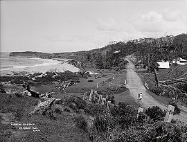
A view at Coledale, circa 1900.Population: 963[1] Postcode: 2515 Coordinates: 34°17′S 150°57′E / 34.283°S 150.95°ECoordinates: 34°17′S 150°57′E / 34.283°S 150.95°E LGA: City of Wollongong State District: Heathcote Federal Division: Cunningham Suburbs around Coledale: Wombarra Coledale Austinmer Coledale is a small sea-side village approximately 18 kilometres north of Wollongong along the Princes Highway in New South Wales, Australia. It is part of the City of Wollongong and lies between Wombarra and Austinmer.
Coledale has several shops on the main road as well as a RSL club, public hall, fire station, private hospital and nursing home. Coledale's shops include a newsagent, 2 cafe's, video shop, hair dresser, pizza/fast food takeout and a bottle shop. Coledale also has a small public school with good views of Coledale beach.
Coledale also has a playing field for soccer and cricket: St. James Park is the home ground for the Coledale Waves and Coledale Rosebuds soccer teams. This was where Kerryn McCann often trained as she lived close by.
Contents
Beaches
Coledale has two sandy beaches: Coledale Beach to the north of the village which is patrolled during summer and Sharkey's Beach to the south - a popular surfing spot. In the summer months Coledale Lifesaving Club runs Nippers every 2nd Sunday on Coledale Beach.
Transport
Coledale railway station is located half way up Cater Street, off Lawrence Hargrave Drive. The station is operated by City Rail. Coledale station is an historic station and still has rubbish bins, unlike many of the stations on the City Rail network where the bins have been removed for security reasons.[citation needed]
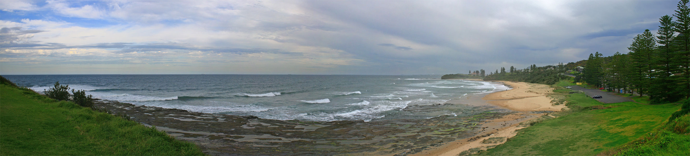
 A panorama overlooking Sharkey's beach facing south in the direction of the Headlands Hotel.
References
- ^ Australian Bureau of Statistics (25 October 2007). "Coledale (State Suburb)". 2006 Census QuickStats. http://www.censusdata.abs.gov.au/ABSNavigation/prenav/LocationSearch?collection=Census&period=2006&areacode=SSC15061&producttype=QuickStats&breadcrumb=PL&action=401. Retrieved 2009-01-11.
External links
Suburbs and Localities of Wollongong, New South Wales Albion Park · Albion Park Rail · Austinmer · Avon · Avondale · Balarang · Balgownie · Barrack Heights · Barrack Point · Bellambi · Berkeley · Blackbutt · Bombo · Broughton Village · Brownsville · Bulli · Burning Palms · Calderwood · Carrington Falls · Cleveland · Clifton · Coalcliff · Coledale · Coniston · Cordeaux · Cordeaux Heights · Corrimal · Cringila · Croom · Curramore · Dapto · Darkes Forest · Dombarton · Dunmore · East Corrimal · Fairy Meadow · Farmborough Heights · Fernhill · Figtree · Flinders · Foxground · Gerringong · Gerroa · Gwynneville · Haywards Bay · Helensburgh · Horsley · Huntley · Jamberoo · Jerrara · Kanahooka · Keiraville · Kembla Grange · Kembla Heights · Kemblawarra · Kiama · Kiama Downs · Kiama Heights · Knights Hill · Koonawarra · Lake Heights · Lake Illawarra · Lilyvale · Macquarie Pass · Maddens Plains · Mangerton · Marshall Mount · Minnamurra · Mount Keira · Mount Kembla · Mount Ousley · Mount Pleasant · Mount Saint Thomas · Mount Warrigal · North Macquarie · North Wollongong · Oak Flats · Otford · Penrose · Port Kembla · Primbee · Rose Valley · Russell Vale · Saddleback Mountain · Scarborough · Shell Cove · Shellharbour · Shellharbour City Centre · Spring Hill · Stanwell Park · Stanwell Tops · Tarrawanna · Thirroul · Tongarra · Toolijooa · Towradgi · Tullimbar · Unanderra · Upper Kangaroo Valley · Warilla · Warrawong · Werri Beach · West Wollongong · Willow Vale · Windang · Wollongong · Wombarra · Wongawilli · Woonona · Yallah · Yellow Rock
Categories:- Illawarra region geography stubs
- Suburbs of Wollongong, New South Wales

Wikimedia Foundation. 2010.