- Geography of Mars
-
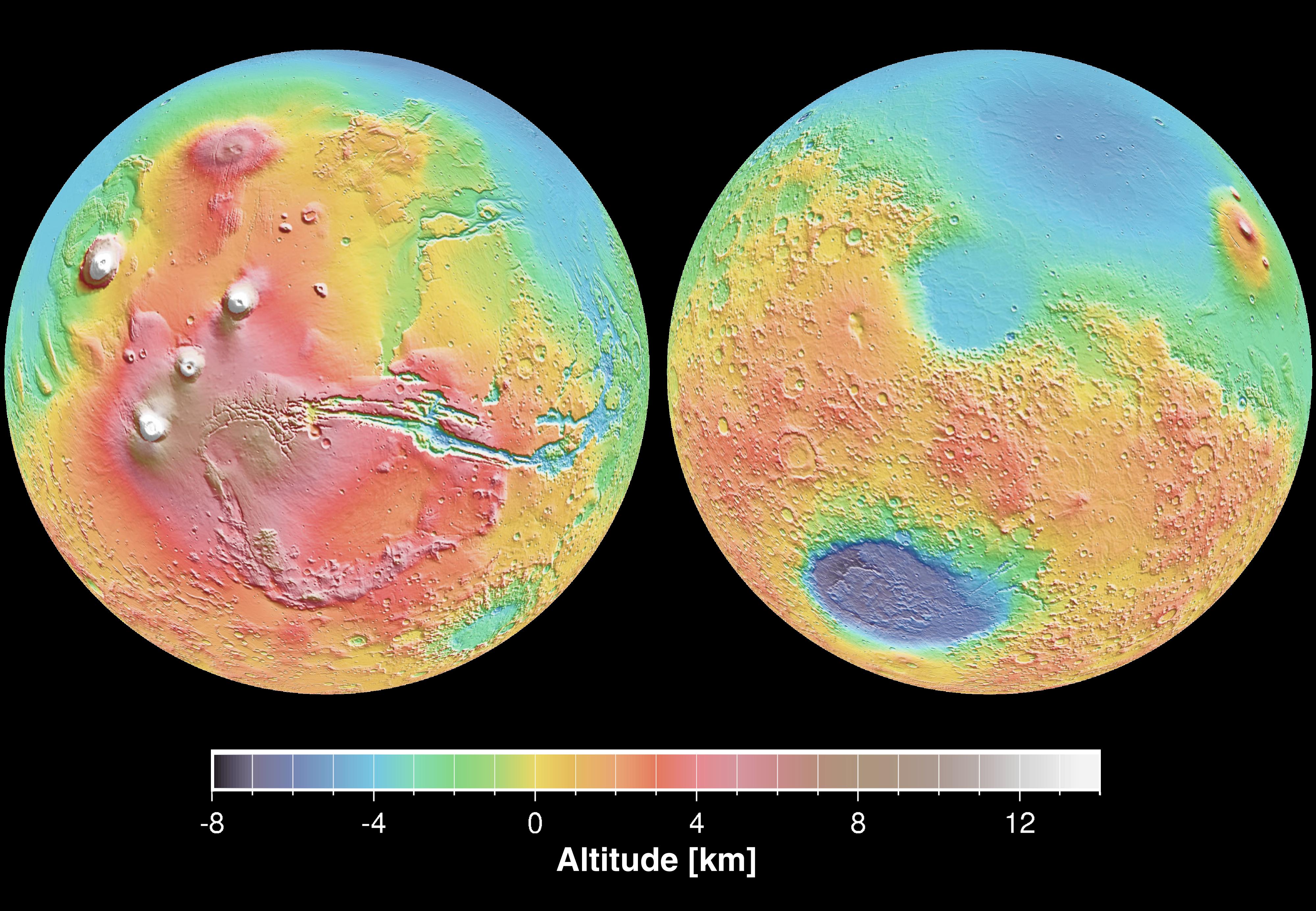
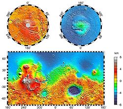 Topographic map of Mars, courtesy NASA Goddard Space Flight Center, from Mars Global Surveyor laser altimeter research led by Maria Zuber and David Smith. North is at the top. Notable features include the Tharsis volcanoes in the west (including Olympus Mons), Valles Marineris to the east of Tharsis, and Hellas Basin in the southern hemisphere.
The geography of Mars, also known as areography, entails the delineation and characterization of regions on Mars. Martian geography is mainly focused on what is called physical geography on Earth; that is the distribution of physical features across Mars and their cartographic representations.
Contents
History
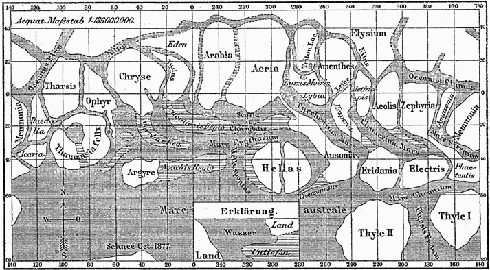
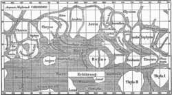 Map of Mars by Giovanni Schiaparelli. North is at the top of this map; however, in most maps of Mars drawn before space exploration the convention among astronomers was to put south at the top because the telescopic image of a planet is inverted.
The first observations of Mars were from ground-based telescopes. The history of these observations are marked by the oppositions of Mars, when the planet is closest to Earth and hence is most easily visible, which occur every couple of years. Even more notable are the perihelic oppositions of Mars which occur approximately every 16 years, and are distinguished because Mars is close to perihelion making it even closer to Earth.
In September 1877, (a perihelic opposition of Mars occurred on September 5), Italian astronomer Giovanni Schiaparelli published the first detailed map of Mars. These maps notably contained features he called canali ("channels"), that were later shown to be an optical illusion. These canali were supposedly long straight lines on the surface of Mars to which he gave names of famous rivers on Earth. His term was popularly mistranslated as canals, and so started the Martian canal controversy.
Following these observations, it was a long held belief that Mars contained vast seas and vegetation. It was not until spacecraft visited the planet during NASA's Mariner missions in the 1960s that these myths were dispelled. Some maps of Mars were made using the data from these missions, but it wasn't until the Mars Global Surveyor mission, launched in 1996 and ending in late 2006, that complete, extremely detailed maps were obtained. These maps are now available online at http://www.google.com/mars/
Interactive map of Mars
The following map has embedded links, click on the features and you will be taken to the corresponding article pages. North is at the top.


Topography
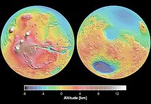 Elevation map of Mars based on Mars Global Surveyor data
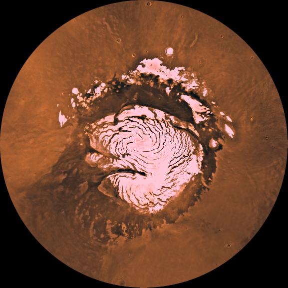
 Mars, 2001, with the southern polar ice cap visible on the bottom.
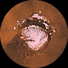 North Polar region with icecap. (Courtesy NASA/JPL-Caltech.)
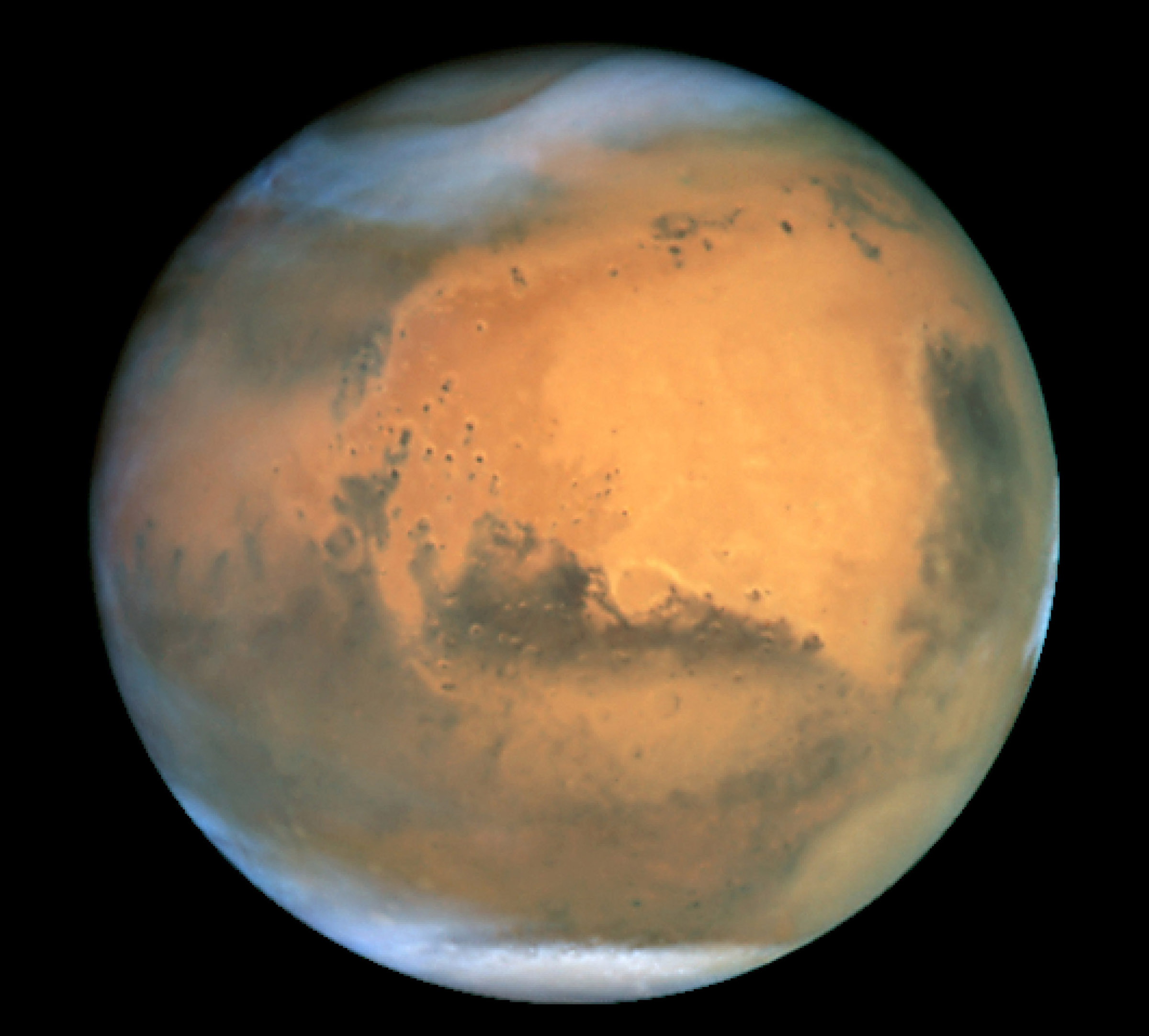
The dichotomy of Martian topography is striking: northern plains flattened by lava flows contrast with the southern highlands, pitted and cratered by ancient impacts. The surface of Mars as seen from Earth is consequently divided into two kinds of areas, with differing albedo. The paler plains covered with dust and sand rich in reddish iron oxides were once thought of as Martian 'continents' and given names like Arabia Terra (land of Arabia) or Amazonis Planitia (Amazonian plain). The dark features were thought to be seas, hence their names Mare Erythraeum, Mare Sirenum and Aurorae Sinus. The largest dark feature seen from Earth is Syrtis Major Planum.
The shield volcano, Olympus Mons (Mount Olympus), is at 26 km the highest known mountain in the solar system. It is in a vast upland region called Tharsis, which contains several large volcanos. See list of mountains on Mars. The Tharsis region of Mars also has the solar system's largest canyon system, Valles Marineris or the Mariner Valley, which is 4,000 km long and 7 km deep. Mars is also scarred by a number of impact craters. The largest of these is the Hellas impact basin, covered with light red sand. See list of craters on Mars.
Mars has two permanent polar ice caps, the northern one located at Planum Boreum and the southern one at Planum Australe.
The difference between Mars' highest and lowest points is nearly 31 km (from the top of Olympus Mons at an altitude of 26 km to the bottom of the Hellas impact basin at an altitude of 4 km below the datum). In comparison, the difference between Earth's highest and lowest points (Mount Everest and the Mariana Trench) is only 19.7 km. Combined with the planets' different radii, this means Mars is nearly three times "rougher" than Earth.
The International Astronomical Union's Working Group for Planetary System Nomenclature is responsible for naming Martian surface features.
Zero elevation
Since Mars has no oceans and hence no 'sea level', it is convenient to define an arbitrary zero-elevation level or "datum" for mapping the surface. The datum for Mars is defined in terms of the height at which the air has a particular pressure at about the freezing point of water: a pressure of 610.5 Pa (6.105 mbar), approximately 0.6% of Earth's, at a temperature of 273.16 K. This pressure and temperature correspond to the triple point of water. Conditions on Mars are so different from those on Earth that Martian altitude readings should not be directly compared to Earthly ones for purposes of finding life, potential colony sites, etc..
Zero meridian
Mars' equator is defined by its rotation, but the location of its Prime Meridian was specified, as was Earth's, by choice of an arbitrary point which was accepted by later observers. The German astronomers Wilhelm Beer and Johann Heinrich Mädler selected a small circular feature as a reference point when they produced the first systematic chart of Mars features in 1830-32. In 1877, their choice was adopted as the prime meridian by the Italian astronomer Giovanni Schiaparelli when he began work on his notable maps of Mars. After the spacecraft Mariner 9 provided extensive imagery of Mars in 1972, a small crater (later called Airy-0), located in the Sinus Meridiani ('Middle Bay' or 'Meridian Bay') along the line of Beer and Mädler, was chosen by Merton Davies of the RAND Corporation to provide a more precise definition of 0.0° longitude when he established a planetographic control point network.
Martian dichotomy
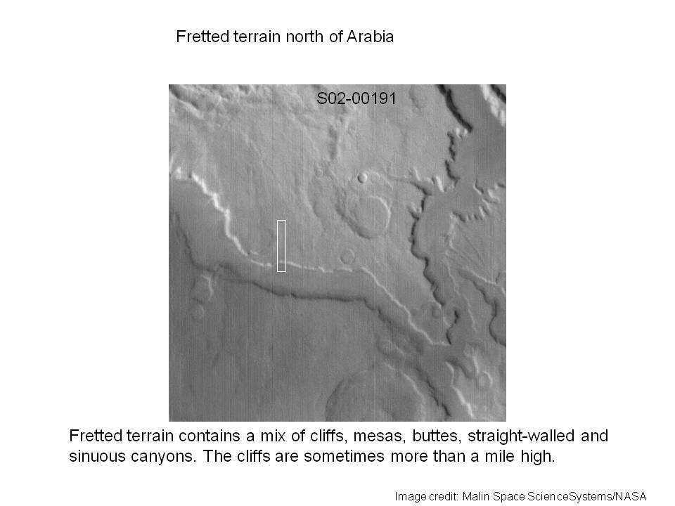
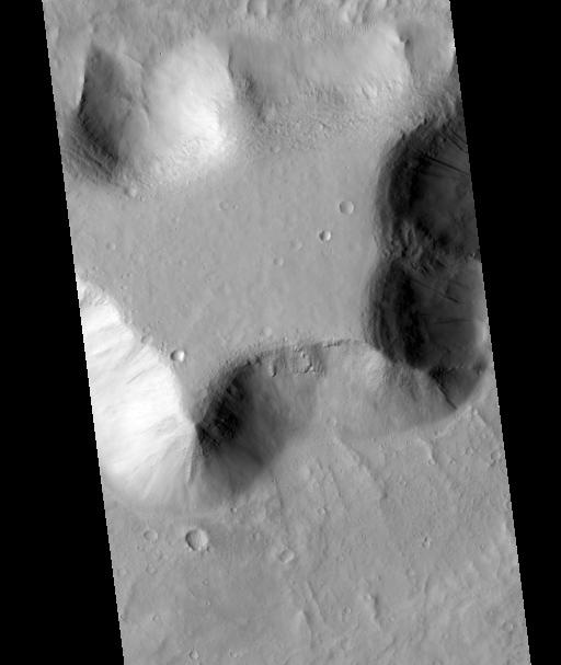
Main article: Martian dichotomyObservers of Martian topography will notice a dichotomy between the northern and southern hemispheres. The northern hemisphere is flat with few impact craters caused by asteroids. Most of the northern hemisphere is below the determined ‘zero elevation’ level. In contrast, the southern hemisphere is mountains and highlands, well above zero-elevation. The two hemispheres differ in elevation by 1 to 3 km. The border separating the two areas is very interesting to geologists. One distinctive feature is the Fretted terrain.[1] It contains mesas, knobs, and flat-floored valleys having walls about a mile high. Around many of the mesas and knobs are lobate debris aprons that have been shown to be rock covered glaciers.[2] These glaciers may be used by future colonists as a source of water. Other interesting features are the large river valleys that cut through the dichotomy.[3][4][5]
-

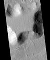
Fretted terrain of Ismenius Lacus showing flat floored valleys and cliffs. Photo taken with Mars Orbiter Camera (MOC) on the Mars Global Surveyor.
-

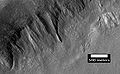
Enlargement of the photo on the left showing cliff. Photo taken with high resolution camera of Mars Global Surveyor (MGS).
-
View of lobate debris apron along a slope. Image located in Arcadia quadrangle.
-
Place where a lobate debris apron begins. Note stripes which indicate movement. Image located in Ismenius Lacus quadrangle.
The northern lowlands comprise about one-third of the surface of Mars and are relatively flat, with occasional impact craters. The other two-thirds of the Martian surface are the highlands of the southern hemisphere. The difference in elevation between the hemispheres is dramatic. Because of the density of impact craters, scientists believe the southern hemisphere to be far older than the northern plains.[6] The heavily cratered southern highlands date back to the period of heavy bombardment.
Multiple hypotheses have been proposed to explain the differences. The three most commonly accepted are: creation by a single mega-impact, creation by multiple impacts, or creation by endogenic processes such as mantle convection.[7] Both impact-related hypotheses involve processes that could have occurred before the end of the primordial bombardment, implying that the crustal dichotomy has its origins early in the history of Mars.
Originally proposed in the early 1980s, the Giant Impact Theory was met with skepticism due to the impact area's non-radial (elliptical) shape, where a circular pattern would be stronger support for impact by larger object(s). But a 2008 study[8] provided additional research that supports the single giant impact theory. Using geologic data, researchers found support for the single impact of a large object hitting Mars at approximately a 45-degree angle. Additional evidence analyzing Martian rock chemistry for post-impact upwelling of mantle material would further support the giant impact theory.
Nomenclature
Early nomenclature
Although better remembered for mapping the Moon starting in 1830, Johann Heinrich Mädler and Wilhelm Beer were the first "areographers". They started off by establishing once and for all that most of the surface features were permanent, and pinned down Mars' rotation period. In 1840, Mädler combined ten years of observations and drew the first map of Mars ever made. Rather than giving names to the various markings they mapped, Beer and Mädler simply designated them with letters; Meridian Bay (Sinus Meridiani) was thus feature "a".
Over the next twenty years or so, as instruments improved and the number of observers also increased, various Martian features acquired a hodge-podge of names. To give a couple of examples, Solis Lacus was known as the "Oculus" (the Eye), and Syrtis Major was usually known as the "Hourglass Sea" or the "Scorpion". In 1858, it was also dubbed the "Atlantic Canale" by the Jesuit astronomer Angelo Secchi. Secchi commented that it "seems to play the role of the Atlantic which, on Earth, separates the Old Continent from the New" —this was the first time the fateful canale, which in Italian can mean either "channel" or "canal", had been applied to Mars.
In 1867, Richard Anthony Proctor drew up a map of Mars based, somewhat crudely, on the Rev. William Rutter Dawes' earlier drawings of 1865, then the best ones available. Proctor explained his system of nomenclature by saying, "I have applied to the different features the names of those observers who have studied the physical peculiarities presented by Mars." Here are some of his names, paired with those later used by Schiaparelli in his Martian map created between 1877 and 1886.[9] Schiaparelli's names were generally adopted and are the names actually used today:
- Kaiser Sea = Syrtis Major
- Lockyer Land = Hellas Planitia
- Main Sea = Lacus Moeris
- Herschel II Strait = Sinus Sabaeus
- Dawes Continent = Aeria and Arabia
- De La Rue Ocean = Mare Erythraeum
- Lockyer Sea = Solis Lacus
- Dawes Sea = Tithonius Lacus
- Madler Continent = Chryse Planitia, Ophir, Tharsis
- Maraldi Sea = Maria Sirenum and Cimmerium
- Secchi Continent = Memnonia
- Hooke Sea = Mare Tyrrhenum
- Cassini Land = Ausonia
- Herschel I Continent = Zephyria, Aeolis, Aethiopis
- Hind Land = Libya
Proctor's nomenclature has often been criticized, mainly because so many of his names honored English astronomers, but also because he used many names more than once. In particular, Dawes appeared no fewer than six times (Dawes Ocean, Dawes Continent, Dawes Sea, Dawes Strait, Dawes Isle, and Dawes Forked Bay). Even so, Proctor's names are not without charm, and for all their shortcomings they were a foundation on which later astronomers would improve.
Modern nomenclature
Main article: Planetary nomenclature#MarsToday, names of Martian features derive from a number of sources. Large albedo features retain many of the older names, but are often updated to reflect new knowledge of the nature of the features. For example 'Nix Olympica' (the snows of Olympus) has become Olympus Mons (Mount Olympus).
Large Martian craters are named after important scientists and science fiction writers; smaller ones are named after towns and villages on Earth.
Various landforms studied by the Mars Exploration Rovers are given temporary names or nicknames to identify them during exploration and investigation. However, it is hoped that the International Astronomical Union will make permanent the names of certain major features, such as the Columbia Hills, which were named after the seven astronauts who died in the Space Shuttle Columbia disaster.
See also
- Geology of Mars
- Martian dichotomy
- List of quadrangles on Mars
- Category:Surface features of Mars - Category of various surface features on Mars
References
- ^ Greeley, R. and J. Guest. 1987. Geological map of the eastern equatorial region of Mars, scale 1:15,000,000. U. S. Geol. Ser. Misc. Invest. Map I-802-B, Reston, Virginia
- ^ Plaut, J. et al. 2008. Radar Evidence for Ice in lobate debris aprons in the Mid-Northern Latitudes of Mars. Lunar and Planetary Science XXXIX. 2290.pdf
- ^ Watters, T. et al. 2007. Hemispheres Apart: The Crustal Dichotomy on Mars. Annual Review Earth Planet Science: 35. 621-652
- ^ Irwin III, R. et al. 2004. Sedimentary resurfacing and fretted terrain development along the crustal dichotomy boundary, Aeolis Mensae, Mars.: 109. E09011
- ^ Tanaka, K. et al. 2003. Resurfacing history of the northern plains of Mars based on geologic mapping of Mars Global surveyor data. Journal of Geophical Research: 108. 8043
- ^ Scott, D. and M. Carr. 1978. Geological map of Mars. U.S. Geol. Surv. Misc. Invest. Map I-803, Reston, Virginia
- ^ Watters, T et al. 2007. Hemispheres Apart: The Crustal Dichotomy on Mars. Annu. Rev. Earth Planet. Sci: 35. 621-652.
- ^ Jeffrey C. Andrews-Hanna, Maria T. Zuber & W. Bruce Banerdt The Borealis basin and the origin of the martian crustal dichotomy Nature 453, 1212-1215 (26 June 2008)
- ^ Ley, Willy and von Braun, Wernher The Exploration of Mars New York:1956 The Viking Press Pages 70-71 Schiaparelli's original map of Mars
Further reading
- Sheehan, William, "The Planet Mars: A History of Observation and Discovery" (Full text online) The University of Arizona Press, Tucson. 1996.
External links
- Google Mars - Google Maps for Mars, with various surface features and interesting places pointed out
- Mars Maps - Maps of Mars
- MEC-1 Prototype
- Historical Globes of the Red Planet
Mars Areography General- Observation history
- Albedo features (Solis Lacus)
- Atmosphere
- Canals (list)
- Climate
- Color
- Water
- Glaciers
- Life
- North Polar Basin
- Chaos terrain
- Noachian
- Soil
Regions- Alba Mons
- Albor Tholus
- Arsia Mons
- Ascraeus Mons
- Biblis Tholus
- Elysium Mons
- Hecates Tholus
- Olympus Mons
- Pavonis Mons
- Syrtis Major Planum
- Tharsis
- Tharsis Montes
- North Polar Basin
- Hellas Planitia
- Argyre Planitia
- Schiaparelli
- Gusev
- Eberswalde
- Bonneville
- Eagle
- Endeavour
- Endurance
- Erebus
- Victoria
- Gale
- Galle
- Ibragimov
- Santa Maria
- Valles
- Chasmata
- Outflow channel
- Valles Marineris

Moons Specific- Phobos
- (Features
- Stickney crater
- Monolith)
- Deimos
- (Features)
CommonExploration Past and
CurrentFutureAstronomy EclipsesAsteroidsMeteorites Other topics - Darian calendar
- Timekeeping on Mars
- Flag of Mars
- In Fiction
- Martian
- Mars Society
- (FMARS
- MDRS)
- Mars Institute
- (Haughton–Mars Project)
- Mythology
- Ocean Hypothesis
Categories:- Mars
- Geography by place
-


Wikimedia Foundation. 2010.