- Planum Boreum
-
Planum Boreum 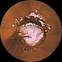
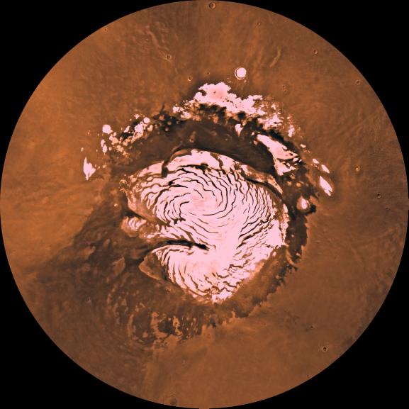
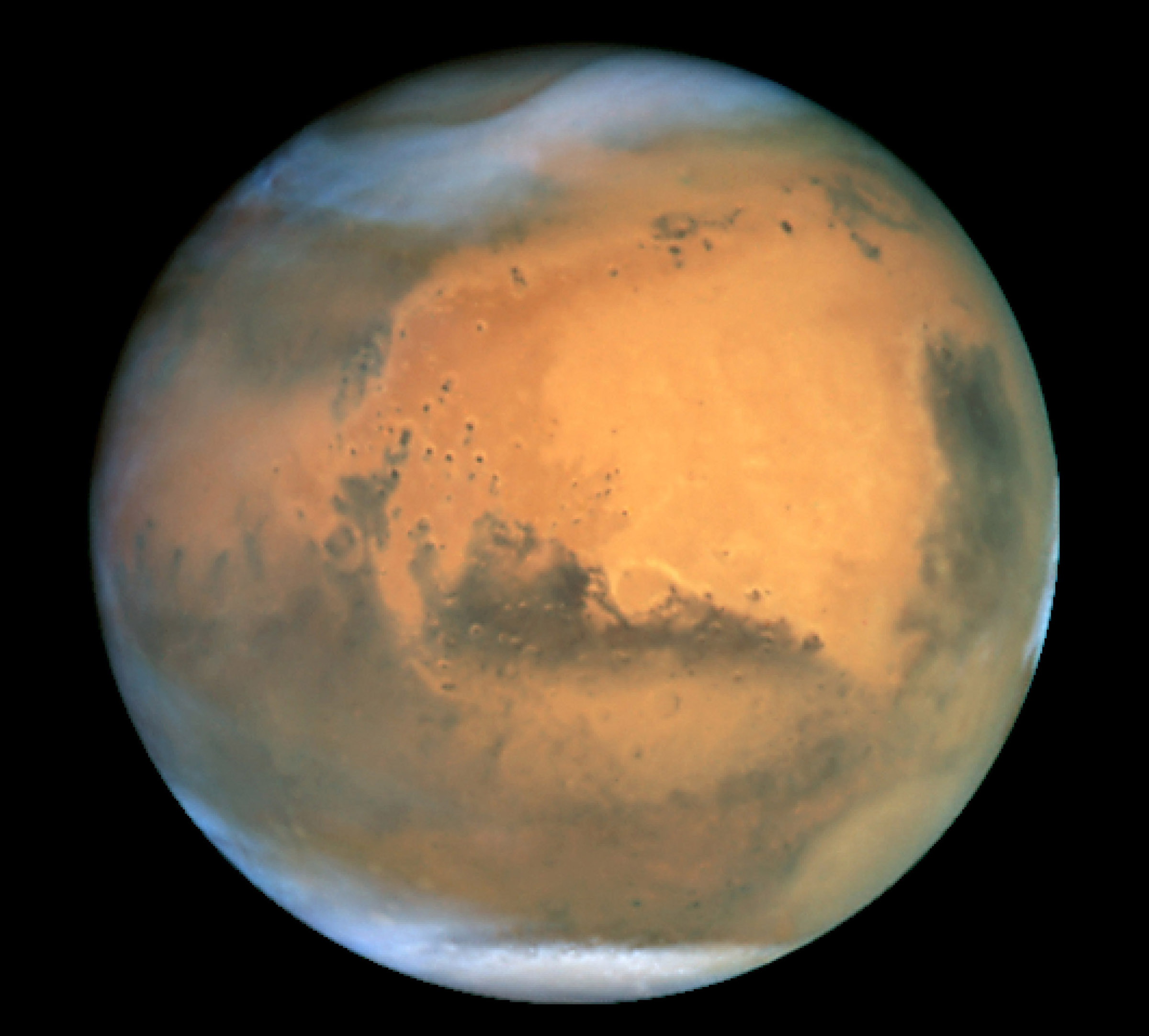
Viking mosaic of Planum Boreum and surroundsCoordinates 88°00′N 15°00′E / 88.0°N 15.0°ECoordinates: 88°00′N 15°00′E / 88.0°N 15.0°E Planum Boreum (Latin: "the northern plain") is the northern polar plain on Mars. It extends northward from roughly 80°N and is centered at 88°00′N 15°00′E / 88.0°N 15.0°E. Surrounding the high polar plain is a flat and featureless lowland plain called Vastitas Borealis which extends for approximately 1500 kilometres southwards, dominating the northern hemisphere.[1] In 1999, the Hubble Space Telescope captured a cyclonic storm in the region. The diameter of the storm was approximately 1750 km and featured an eye 320 kilometres in diameter.[2]
Contents
Ice cap
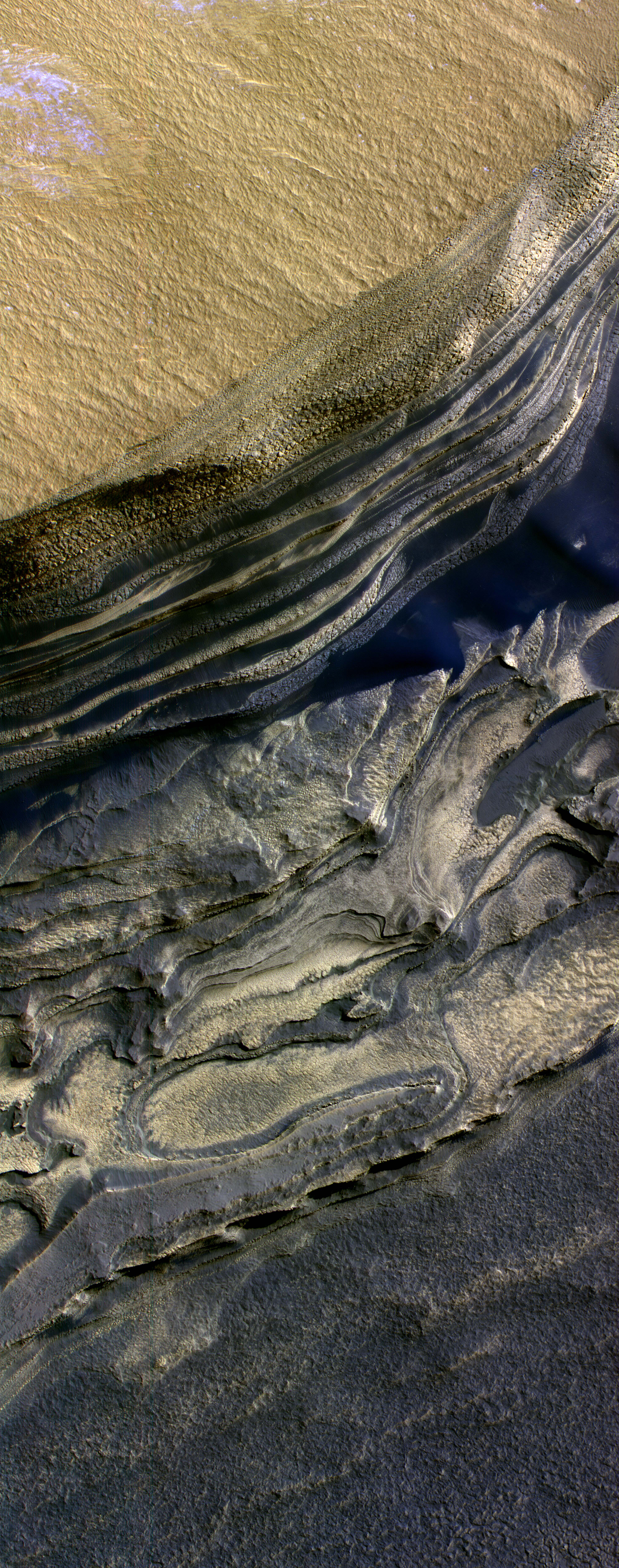
 False color Mars Reconnaissance Orbiter image of a side of the Chasma Boreale, a canyon in the polar ice cap. Light browns are layers of surface dust greys and blues are layers of water and carbon dioxide ice. Regular geometric cracking is indicative of higher concentrations of water ice.
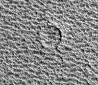 HiRISE image of a crater in the north polar ice cap
Planum Boreum is home to a permanent ice cap consisting mainly of water and carbon dioxide ice. It has a volume of 1.2 million cubic kilometres and covers an area equivalent to about 1.5 times the size of Texas. It has a radius of 600 km. The maximum depth of the cap is 3 km.[3] The spiral patterns in the ice cap are dune-like features analogous to megadunes in Antarctica. Katabatic winds driven by the Coriolis effect entrain and redeposit surface ice to make the pattern.[4][5]
The surface composition of the northern ice cap in middle spring (after a winter's accumulation of seasonal dry ice) has been studied from orbit. The outer edges of the ice cap are contaminated with dust (0.15% by weight) and are mostly water ice. As one moves toward the pole, the surface water ice content decreases and is replaced by dry ice. The purity of the ice also increases. At the pole, the surface seasonal ice consists of essentially pure dry ice with little dust content and 30 parts per million of water ice.[6]
The Phoenix lander, launched in 2007, arrived at Mars in May 2008 and successfully landed in the Vastitas Borealis region of the planet on May 25, 2008. The polar cap of Mars has been proposed as a landing site for a human Mars expedition by Landis[7] and by Cockell.[8]
Features
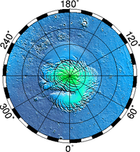 Elevation map of the north pole. Note how Planum Boreum soars above the surrounding featureless terrain. Click to enlarge and for more info.
The main feature of the Planum Boreum is a large fissure or canyon in the polar ice cap called Chasma Boreale. It is up to 100 km wide and features scarps up to 2 km high.[9][10] By comparison, the Grand Canyon is approximately 1.6 km deep in some places and 446 km long but only up to 24 km wide. Chasma Boreale cuts through polar deposits and ice, such as those present at Greenland.
Planum Boreum interfaces with Vastitas Borealis west of Chasma Boreale at an irregular scarp named Rupes Tenuis. This scarp reaches heights of up to 1 km. At other places, the interface is a collection of mesas and troughs.
Planum Boreum is surrounded by large fields of sand dunes spanning from 75°N to 85°N. These dune fields are named Olympia Undae, Abalos Undae and Hyperboreae Undae. Olympia Undae, by far the largest, covers from 100°E to 240°E. Abalos Undae covers from 261°E to 280°E and Hyperboreale Undae spans from 311°E to 341°E.[11] See also List of extraterrestrial dune fields.
Avalanches
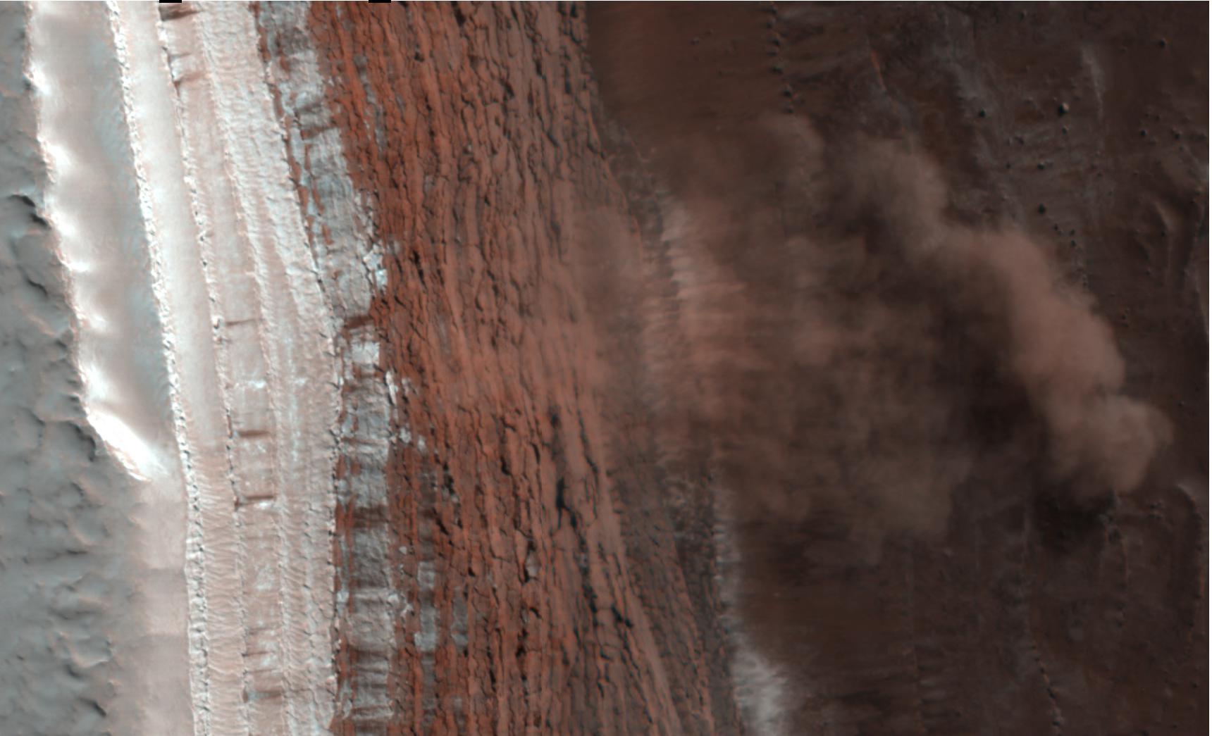
 False color view of a Martian avalanche.
A February 2008 HiRISE observation captured four avalanches in progress off a 700 meter cliff. The cloud of fine material is 180 meters across and extends 190 meters from the base of the cliff. The reddish layers are known to be rock rich in water ice while the white layers are seasonal carbon dioxide frost. The landslide is thought to have originated from the uppermost red layer. Follow-up observations are planned to characterize the nature of the landslide debris.[12][13]
See also
- Planum Australe, the south polar plain
- Vastitas Borealis
References
- ^ [1] and [2] give Vastitas Borealis starting at 54.7°N and Planum Boreum at 78.5°N. The radius of Mars is approximately 3400 km, so

- ^ "Colossal Cyclone Swirls near Martian North Pole". http://hubblesite.org/newscenter/archive/releases/1999/22/text/. Retrieved 2006-11-01.
- ^ "Laser provides first 3-D View of Mars' North Pole". Archived from the original on 2006-10-17. http://web.archive.org/web/20061017122112/http://ltpwww.gsfc.nasa.gov/tharsis/agu_f98.html. Retrieved 2006-11-01.
- ^ Smith, Isaac B.; Holt, J. W. (2010). "Onset and migration of spiral troughs on Mars revealed by orbital radar". Nature 465 (4): 450–453. Bibcode 2010Nature....32..450P. doi:10.1038/nature09049. http://www.nature.com/nature/journal/v465/n7297/full/nature09049.html.
- ^ "Mystery Spirals on Mars Finally Explained". Space.com. 26 May 2010. http://www.space.com/8494-mystery-spirals-mars-finally-explained.html. Retrieved 2010-5-26.
- ^ "Spatial variability and composition of the seasonal north polar cap on Mars". http://www-mars.lmd.jussieu.fr/granada2006/abstracts/Giuranna_Granada2006.pdf. Retrieved 2006-11-01.
- ^ G. Landis, Polar Landing Site for a First Mars Expedition Founding Convention of the Mars Society, August 13–16, 1998, University of Colorado in Boulder, CO
- ^ Project Boreas C. Cockell (editor), Project Boreas - A Station for the Martian Geographic North Pole, The British Interplanetary Society (2006)
- ^ "Fly over the Chasma Boreale at Martian north pole". European Space Agency. http://www.esa.int/SPECIALS/Mars_Express/SEM8T86Y3EE_0.html. Retrieved 2006-11-01.
- ^ "Geologic Map of the Northern Plains of Mars". United States Geological Survey. http://pubs.usgs.gov/sim/2005/2888/sim2888pamphlet.pdf. Retrieved 2006-01-11.
- ^ "USGS Astro: Search Planetary Nomenclature". http://planetarynames.wr.usgs.gov/jsp/AdvanceSearch2.jsp?system=ALL&system=ALL&fname=undae&ft=ALL&diamgt=&diamlt=&nlat=&slat=&wlon=&elon=&lonDirection=null&adb=&ade=&as=ANY&cont=ðn=&refN=&refT=&quad=&map=&QuickSearch=true&sort=AP. Retrieved 2006-11-01.
- ^ "Avalanche on Mars". Scientific American. 2008-03-04. http://www.sciam.com/gallery_directory.cfm?photo_id=7B82B079-C057-F0CF-D15B555DBA34B1CF. Retrieved 2008-03-05.
- ^ "NASA Spacecraft Photographs Avalanches on Mars". 2008-03-03. http://www.jpl.nasa.gov/news/news.cfm?release=2008-036. Retrieved 2008-03-05.
External links
- Fly over the Chasma Boreale at Martian north pole - courtesy of Mars Express
- Geologic Map of the Northern Plains of Mars
- HiRISE image of Martian landslides
- HiRISE image of permanent ice mound separated from cap
- Various HiRISE images of the north polar ice cap: [3] [4] [5] [6]
Mars Areography General- Observation history
- Albedo features (Solis Lacus)
- Atmosphere
- Canals (list)
- Climate
- Color
- Water
- Glaciers
- Life
- North Polar Basin
- Chaos terrain
- Noachian
- Soil
Regions- Alba Mons
- Albor Tholus
- Arsia Mons
- Ascraeus Mons
- Biblis Tholus
- Elysium Mons
- Hecates Tholus
- Olympus Mons
- Pavonis Mons
- Syrtis Major Planum
- Tharsis
- Tharsis Montes
- North Polar Basin
- Hellas Planitia
- Argyre Planitia
- Schiaparelli
- Gusev
- Eberswalde
- Bonneville
- Eagle
- Endeavour
- Endurance
- Erebus
- Victoria
- Gale
- Galle
- Ibragimov
- Santa Maria
- Valles
- Chasmata
- Outflow channel
- Valles Marineris

Moons Specific- Phobos
- (Features
- Stickney crater
- Monolith)
- Deimos
- (Features)
CommonExploration Past and
CurrentFutureAstronomy EclipsesAsteroidsMeteorites Other topics - Darian calendar
- Timekeeping on Mars
- Flag of Mars
- In Fiction
- Martian
- Mars Society
- (FMARS
- MDRS)
- Mars Institute
- (Haughton–Mars Project)
- Mythology
- Ocean Hypothesis
Categories:- Mare Boreum quadrangle
- Plains on Mars


Wikimedia Foundation. 2010.