Chasma Boreale

Chasma Boreale
Chasma Boreale
Chasma Boreale Channels.jpg
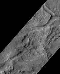
Chasma Boreale Channels, as seen by HiRISE.
Coordinates 83°00′N 47°06′W / 83°N 47.1°W / 83; -47.1Coordinates: 83°00′N 47°06′W / 83°N 47.1°W / 83; -47.1
v · d · e

Chasma Boreale is a large canyon in the Mare Boreum quadrangle of Mars at 83° north latitude and 47.1° west longitude. It is about 560 km (350 mi) long and was named after a classical albedo feature name.[1] The canyon shows layered features that result from seasonal melting and deposition of ice, together with dust deposits from Martian dust storms. Information about the past climate of Mars may eventually be revealed in these layers, just as tree ring patterns and ice core data do on Earth. Both polar caps also display grooved features, probably caused by wind flow patterns. The grooves are also influenced by the amount of dust.[2] The more dust, the darker the surface. The darker the surface, the more melting. Dark surfaces absorb more light energy.

Gallery

References


Wikimedia Foundation. 2010.

Игры ⚽ Поможем решить контрольную работу

Look at other dictionaries:

  • Géologie de la planète Mars — La géologie de la planète Mars, parfois appelée aréologie[1], recouvre l étude scientifique de Mars et de ses propriétés physiques, de ses reliefs, de sa composition, de son histoire, et de tous les phénomènes qui ont affecté ou affectent encore… …   Wikipédia en Français

  • Planum Boreum — Viking mosaic of Planum Boreum and surrounds Coordinates …   Wikipedia

  • Mare Boreum quadrangle — The Mare Boreum quadrangle is one of a series of 30 quadrangle maps of Mars used by the United States Geological Survey (USGS) Astrogeology Research Program. The Mare Boreum quadrangle is also referred to as MC 1 (Mars Chart 1).[1] Map of Mare… …   Wikipedia

  • Planum Boreum — Saltar a navegación, búsqueda Imagen mosaico del polo norte marciano, Programa Viking. El Planum Boreum (del latín: el plano septentrional ) es el polo norte del planeta Marte. Se extiende hacia el norte desde la latitud 80°N y está centrado en… …   Wikipedia Español

  • Chasmas martiens — Liste de chasmas martiens Voici une liste de chasmas martiennes. Arsia Chasmata Ascraeus Chasmata Baetis Chasma Candor Chasma Capri Chasma Ceti Chasma Chasma Australe Chasma Boreale Coprates Chasma Echus Chasma Elysium Chasma Eos Chasma Ganges… …   Wikipédia en Français

  • Liste de Chasmas martiens — Voici une liste de chasmas martiennes. Arsia Chasmata Ascraeus Chasmata Baetis Chasma Candor Chasma Capri Chasma Ceti Chasma Chasma Australe Chasma Boreale Coprates Chasma Echus Chasma Elysium Chasma Eos Chasma Ganges Chasma Hebes Chasma Hyblaeus …   Wikipédia en Français

  • Liste de chasmas martiens — Voici une liste de chasmata martiennes. Arsia Chasmata Ascraeus Chasmata Baetis Chasma Candor Chasma Capri Chasma Ceti Chasma Chasma Australe Chasma Boreale Coprates Chasma Echus Chasma Elysium Chasma Eos Chasma Ganges Chasma Hebes Chasma… …   Wikipédia en Français

  • Outflow channels — Kasei Valles, seen in MOLA elevation data. Flow was from bottom left to right. North is up. Image is approx. 1600 km across. The channel system extends another 1200 km south of this image to Hebes Chasma. Outflow channels is the term used to… …   Wikipedia

  • Project Boreas — was a study conducted between 2003 and 2006 by the British Interplanetary Society to design a station for the Martian North Pole [Project Boreas: A Station for the Martian Geographic North Pole, Editor C. S. Cockell, British Interplanetary… …   Wikipedia

  • Северный разлом — Координаты: 82° 53′  с. ш. 44° 7′  з. д. (G) …   Википедия

Share the article and excerpts

Direct link
Do a right-click on the link above
and select “Copy Link”