- Planum Australe
-
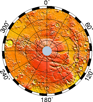
Planum Australe 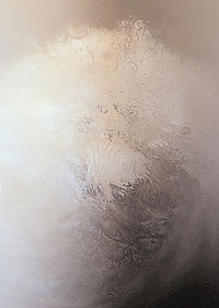
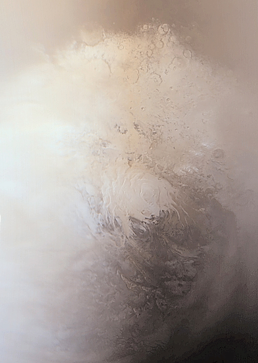
Planum Australe, taken by Mars Global Surveyor.Coordinates 83°54′S 160°00′E / 83.9°S 160.0°ECoordinates: 83°54′S 160°00′E / 83.9°S 160.0°E Planum Australe (Latin: "the southern plain") is the southern polar plain on Mars. It extends southward of roughly 75°S and is centered at 83°54′S 160°00′E / 83.9°S 160.0°E. The geology of this region was to be explored by the failed NASA mission Mars Polar Lander, which lost contact on entry into the Martian atmosphere.
Contents
Ice cap
Planum Australe is partially covered by a permanent polar ice cap composed of frozen water and carbon dioxide about 3 km thick. A seasonal ice cap forms on top of the permanent one during the Martian winter, extending from 60°S southwards. It is, at the height of winter, approximately 1 meter thick.[1] It is possible that the area of this ice cap may be shrinking due to localized climate change or more widespread global warming.[2]
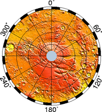 Elevation map of the south pole. Note how Planum Australe rises above the surrounding cratered terrain. Click to enlarge and for more info.
In 1966, Leighton and Murray proposed that the Martian polar caps provided a store of CO2 much larger than the atmospheric reservoir. However it is now thought that both poles are made mostly of water ice. Both poles have a thin seasonal covering of CO2, while in addition the southern pole has a permanent residual CO2 cap, about 8 to 10 metres thick, that lies on top of the water ice. Perhaps the key argument that the bulk of the ice is water is that CO2 ice isn't mechanically strong enough to make a 3 km thick ice cap stable over long periods of time.[3]. Recent evidence from SHARAD ice penetrating radar has revealed a massive subsurface CO2 ice deposit approximately equal to 80% of the current atmosphere, or 4-5 mbar, stored in Planum Australe.[4]
Data from ESA's Mars Express indicates that there are three main parts to the ice cap. The most reflective part of the ice cap is approximately 85% dry ice and 15% water ice. The second part, where the ice cap forms steep slopes at the boundary with the surrounding plain, is almost exclusively water ice. Finally, the ice cap is surrounded by permafrost fields that extend for tens of kilometres north away from the scarps.[5]
The centre of the permanent ice cap is not located at 90°S but rather approximately 150 kilometres north of the geographical south pole. The presence of two massive impact basins in the western hemisphere - Hellas Planitia and Argyre Planitia - creates an immobile area of low pressure over the permanent ice cap. The resulting weather patterns produce fluffy white snow which has a high albedo. This is in contrast to the black ice that forms in the eastern part of the polar region, which receives little snow.[6]
Features
There are two distinct subregions in Planum Australe - Australe Lingula and Promethei Lingula. It is dissected by canyons Promethei Chasma, Ultimum Chasma, Chasma Australe and Australe Sulci. It is theorised that these canyons were created by katabatic wind.[7] The largest crater in Planum Australe is McMurdo Crater.
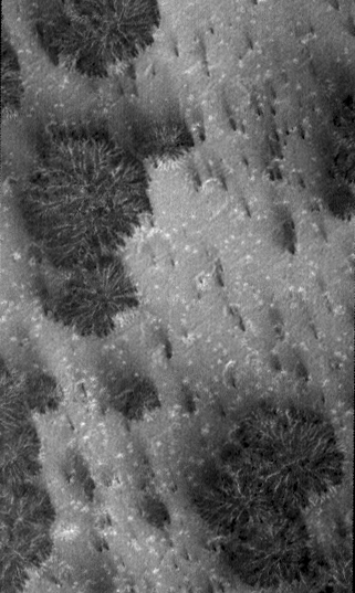
Geysers on Mars
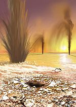 Artist concept showing sand-laden jets erupt from geysers on Mars. (published by NASA; artist: Ron Miller.
 Close up of "dark dune spots" created by geyser-like systems.Main article: Geysers on Mars
The seasonal frosting and defrosting of the southern ice cap results in the formation of spider-like radial channels carved on 1 meter thick ice by sunlight. Then, sublimed CO2 -and probably water- increase pressure in their interior producing geyser-like eruptions of cold fluids often mixed with dark basaltic sand or mud.[8][9][10][11] This process is rapid, observed happening in the space of a few days, weeks or months, a growth rate rather unusual in geology - especially for Mars. No lander is presently planned to visit the dark dune spots and spider areas.
See also
- Planum Boreum, the northern polar plain
- List of plains on Mars
- Climate of Mars
References
- ^ Phillips, Tony. "Mars is Melting". Science @ NASA. http://science.nasa.gov/headlines/y2003/07aug_southpole.htm. Retrieved 2006-10-20.
- ^ Sigurdsson, Steinn. "Global warming on Mars?". RealClimate.org. http://www.realclimate.org/index.php?p=192. Retrieved 2006-10-20.
- ^ Byrne, Shane; Ingersoll, AP (14 February 2003). "A Sublimation Model for Martian South Polar Ice Features". Science 299 (5609): 1051–1053. Bibcode 2003Sci...299.1051B. doi:10.1126/science.1080148. PMID 12586939.
- ^ Philips, R. J. et. al (2011). "Onset and migration of spiral troughs on Mars revealed by orbital radar". Science 332 (13): 838-841. doi:10.1126/science.1203091. http://www.sciencemag.org/content/332/6031/838.full.
- ^ "Water at Martian south pole". European Space Agency. http://www.esa.int/SPECIALS/Mars_Express/SEMYKEX5WRD_0.html. Retrieved 2006-10-22.
- ^ "Mars' South Pole mystery". Spaceflight Now. http://spaceflightnow.com/news/n0505/14marsmystery/. Retrieved 2006-10-26.
- ^ Kolb, Eric J.; Kenneth L. Tanaka (2006). "Accumulation and erosion of south polar layered deposits in the Promethei Lingula region, Planum Australe, Mars". The Mars Journal (Mars Informatics Inc.) 2: 1–9. Bibcode 2006Mars....2....1K. doi:10.1555/mars.2006.0001.
- ^ "NASA Findings Suggest Jets Bursting From Martian Ice Cap". Jet Propulsion Laboratory (NASA). August 16, 2006. http://www.jpl.nasa.gov/news/news.cfm?release=2006-100. Retrieved 2009-08-11.
- ^ Kieffer, H. H. (2000). "ANNUAL PUNCTUATED CO2 SLAB-ICE AND JETS ON MARS." (PDF). Mars Polar Science 2000. http://www.lpi.usra.edu/meetings/polar2000/pdf/4095.pdf. Retrieved 2009-09-06
- ^ "SIMULATIONS OF GEYSER-TYPE ERUPTIONS IN CRYPTIC REGION OF MARTIAN SOUTH" (PDF). Fourth Mars Polar Science Conference. 2006. http://www.lpi.usra.edu/meetings/polar2006/pdf/8040.pdf. Retrieved 2009-08-11
- ^ Kieffer, Hugh H.; Philip R. Christensen and Timothy N. Titus (30 May 2006). "CO2 jets formed by sublimation beneath translucent slab ice in Mars' seasonal south polar ice cap". Nature 442 (7104): 793–796. Bibcode 2006Natur.442..793K. doi:10.1038/nature04945. PMID 16915284. http://www.nature.com/nature/journal/v442/n7104/abs/nature04945.html. Retrieved 2009-09-02.
External links
- Accumulation and erosion of south polar layered deposits in the Promethei Lingula region, Planum Australe, Mars
- Planum Australe on Google Mars.
- Stratigraphy and Topography of McMurdo Crater area, Planum Australe, Mars
- Topographic maps of the Martian South Pole
- USGS map of Planum Australe
Mars Areography General- Observation history
- Albedo features (Solis Lacus)
- Atmosphere
- Canals (list)
- Climate
- Color
- Water
- Glaciers
- Life
- North Polar Basin
- Chaos terrain
- Noachian
- Soil
Regions- Alba Mons
- Albor Tholus
- Arsia Mons
- Ascraeus Mons
- Biblis Tholus
- Elysium Mons
- Hecates Tholus
- Olympus Mons
- Pavonis Mons
- Syrtis Major Planum
- Tharsis
- Tharsis Montes
- North Polar Basin
- Hellas Planitia
- Argyre Planitia
- Schiaparelli
- Gusev
- Eberswalde
- Bonneville
- Eagle
- Endeavour
- Endurance
- Erebus
- Victoria
- Gale
- Galle
- Ibragimov
- Santa Maria
- Valles
- Chasmata
- Outflow channel
- Valles Marineris

Moons Specific- Phobos
- (Features
- Stickney crater
- Monolith)
- Deimos
- (Features)
CommonExploration Past and
CurrentFutureAstronomy EclipsesAsteroidsMeteorites Other topics - Darian calendar
- Timekeeping on Mars
- Flag of Mars
- In Fiction
- Martian
- Mars Society
- (FMARS
- MDRS)
- Mars Institute
- (Haughton–Mars Project)
- Mythology
- Ocean Hypothesis
Categories:- Mare Australe quadrangle
- Plains on Mars

Wikimedia Foundation. 2010.