- Martian dichotomy
-
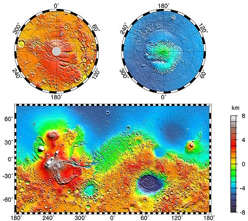

The most conspicuous feature of Martian surface geology is a sharp contrast, known as the Martian dichotomy, between the rugged southern highlands and the relatively smooth northern basins. The two hemispheres differ in elevation by 1 to 3 km. The average thickness of the Martian crust is 45 km, with 32 km in the northern lowlands region, and 58 km in the southern highlands.
The boundary between the two regions is quite complex in places. One distinctive type of topography is called fretted terrain.[1][2][3] It contains mesas, knobs, and flat-floored valleys having walls about a mile high. Around many of the mesas and knobs are lobate debris aprons that have been shown to be rock-covered glaciers.[4][5][6][7]
Many large river valleys cut through the dichotomy.[8][9][10]
The Martian dichotomy boundary includes the regions called Deuteronilus Mensae, Protonilus Mensae, and Nilosyrtis Mensae. All three regions have been studied extensively because they contain landforms believed to have been produced by the movement of ice.[11][12]
The northern lowlands comprise about one-third of the surface of Mars and are relatively flat, with occasional impact craters. The other two-thirds of the Martian surface are the highlands of the southern hemisphere. The difference in elevation between the hemispheres is dramatic. Because of the density of impact craters, scientists believe the southern hemisphere to be far older than the northern plains.[13] The heavily cratered southern highlands date back to the period of heavy bombardment. Three major hypotheses have been proposed for the origin of the crustal dichotomy: endogenic (by mantle processes), single impact, or multiple impact. Both impact-related hypotheses involve processes that could have occurred before the end of the primordial bombardment, implying that the crustal dichotomy has its origins early in the history of Mars.
Contents
Single Impact Hypothesis
A single mega-impact would produce a very large, circular depression in the crust. The proposed depression has been named the Borealis Basin. However, most estimations of the shape of the lowlands area produce a shape that in places dramatically deviates from the circular shape.[14] Additional processes could create those deviations from circularity. Also if the proposed Borealis basin is a depression created by an impact, it would make it the largest impact crater in the Solar System. An object that large could have hit Mars sometime during the process of the Solar System accretion.
It is expected that the impact of such magnitude would have produced an ejecta blanket that should be found in areas around the lowland. However, if the impact occurred around 4.5 Ga, erosional factors could explain the absence of the ejecta blanket. Also, the mega-impact could have scattered a large portion of the debris into outer space and across the southern hemisphere. Geologic evidence of the debris would provide very convincing support for this hypothesis. A 2008 study[15] provided additional research that supports the single giant impact theory. In the past tracing of the impact boundaries was complicated by the presence of the Tharsis volcanic rise. The Tharsis volcanic rise buried the proposed dichotomy boundary under 30 km of basalt. The researchers at MIT and Jet Propulsion Lab at CIT have been able to use gravity and topography of Mars to constrain the location of the dichotomy beneath the Tharsis rise, thus creating an elliptical model of the dichotomy boundary. The elliptical shape of the Borealis Basin further supports the Single Impact Hypothesis. This hypothesis is favored by many due to its relative simplicity, and because impacts of that magnitude were known to occur early in the history of the Solar System.
Endogenic Origin Hypothesis
It is believed that plate tectonic processes could have been active on Mars early in the planet’s history. Large-scale redistribution of lithospheric crustal material is known to be caused by plate tectonic processes on Earth. Even though it is still not entirely clear how mantle processes affect plate tectonics on Earth, mantle convection is believed to be involved as cells or plumes. Since endogenic processes of Earth are still to be completely understood, studying of similar processes on Mars is very difficult. The dichotomy could be created at the time of the creation of the Martian core. The roughly circular shape of the lowland could then be attributed to plume-like first-order overturn which could occur in the process of rapid core formation. There is evidence for internally driven tectonic events in the vicinity of the lowland area that clearly occurred at the end of the early bombardment phase.
A 2005 study[16] suggests that degree-1 mantle convection could have created the dichotomy. Degree-1 mantle convection is a convective process in which one hemisphere is dominated by an upwelling, while the other hemisphere is downwelling. Some of the evidence is the abundance of extensive fracturing and igneous activity of late Noachian to early Hesperian age. A counter argument to the endogenic hypothesis is the possibility of those tectonic events occurring in the Borealis basin due to the post-impact weakening of the crust. In order to further support the endogenic origin hypothesis geologic evidence of faulting and flexing of the crust prior to the end of the primordial bombardment is needed.
Multiple Impact Hypothesis
The multiple impact hypothesis is supported by correlation of segments of the dichotomy with the rims of several large impact basins. But there are large parts of the Borealis Basin outside the rims of those impact basins. If the Martian lowlands were formed by the multiple basins then their inner ejecta and rims should stand above upland elevations. The rims and ejecta blankets of the lowland impact craters are still much below the upland areas. There are also areas in the lowlands that are outside any of the impact basins, these areas must be overlain by multiple ejecta blankets and should stand at elevations similar to the original planetary surface. That clearly is not the case either. One approach explaining the absence of ejecta blankets infers that no ejecta was ever present[17] ). Absence of ejecta could be caused by a large impactor scattering the ejecta into outer space. Another approach proposed the formation of the dichotomy by cooling at depth and crustal loading by later volcanism. The multiple-impact hypothesis is also statistically unfavorable, it is unlikely that multiple impacts basins occur and overlap primarily in the northern hemisphere.
See also
- Geology of Mars
- Areography
- Water on Mars
- Fretted terrain
- Lobate Debris Apron
- Deuteronilus Mensae
- Protonilus Mensae
- Nilosyrtis Mensae
- Glacier
- Glaciers on Mars
References
- ^ Greeley, R. and J. Guest. 1987. Geological map of the eastern equatorial region of Mars, scale 1:15,000,000. U. S. Geol. Ser. Misc. Invest. Map I-802-B, Reston, Virginia
- ^ Sharp, R. 1973. Mars Fretted and chaotic terrains. J. Geophys. Res: 78. 4073-4083
- ^ ISBN 0-8165-1247-7
- ^ Plaut, J. et al. 2008. Radar Evidence for Ice in Lobate Debris Aprons in the Mid-Northern Latitudes of Mars. Lunar and Planetary Science XXXIX. 2290.pdf
- ^ Carr, M. 2006. The Surface of Mars. Cambridge University Press. ISBN 978-0-521-87201-0
- ^ Squyres, S. 1978. Martian fretted terrain: Flow of erosional debrid. Icarus: 34. 600-613.
- ^ ISBN 0-8165-1257-4
- ^ Watters, T. et al. 2007. Hemispheres Apart: The Crustal Dichotomy on Mars. Annual Review Earth Planet Science: 35. 621-652
- ^ Irwin III, R. et al. 2004. Sedimentary resurfacing and fretted terrain development along the crustal dichotomy boundary, Aeolis Mensae, Mars.: 109. E09011
- ^ Tanaka, K. et al. 2003. Resurfacing history of the northern plains of Mars based on geologic mapping of Mars Global surveyor data. Journal of Geophical Research: 108. 8043
- ^ Baker, D. et al. 2010. Flow patterns of lobate debris aprons and lineated valley fill north of Ismeniae Fossae, Mars: Evidence for extensive mid-latitude glaciation in the Late Amazonian. Icarus: 207. 186-209.
- ^ http://www.uahirise.org/ESP_018857_2225
- ^ Scott, D. and M. Carr. 1978. Geological map of Mars. U.S. Geol. Surv. Misc. Invest. Map I-803, Reston VA
- ^ McGill, G. E. & Squyres, S. W Origin of the martian crustal dichotomy: Evaluating hypotheses. Icarus 93, 386–393 (1991)
- ^ Jeffrey C. Andrews-Hanna, Maria T. Zuber & W. Bruce Banerdt The Borealis basin and the origin of the martian crustal dichotomy. Nature 453, 1212-1215 (26 June 2008)
- ^ James H. Roberts, Shijie Zhong Degree-1 convection in the Martian mantle and the origin of the hemispheric dichotomy. Journal Of Geophysical Research 111, (23 June 2006)
- ^ Frey, H., and R.A. Schultz Large impact basins and the mega-impact origin for the crustal dichotomy of Mars. Geophys. Res. Lett. 15 229-232, (March 1988)
External links
Mars Areography General- Observation history
- Albedo features (Solis Lacus)
- Atmosphere
- Canals (list)
- Climate
- Color
- Water
- Glaciers
- Life
- North Polar Basin
- Chaos terrain
- Noachian
- Soil
Regions- Alba Mons
- Albor Tholus
- Arsia Mons
- Ascraeus Mons
- Biblis Tholus
- Elysium Mons
- Hecates Tholus
- Olympus Mons
- Pavonis Mons
- Syrtis Major Planum
- Tharsis
- Tharsis Montes
- North Polar Basin
- Hellas Planitia
- Argyre Planitia
- Schiaparelli
- Gusev
- Eberswalde
- Bonneville
- Eagle
- Endeavour
- Endurance
- Erebus
- Victoria
- Gale
- Galle
- Ibragimov
- Santa Maria
- Valles
- Chasmata
- Outflow channel
- Valles Marineris

Moons Specific- Phobos
- (Features
- Stickney crater
- Monolith)
- Deimos
- (Features)
CommonExploration Past and
CurrentFutureAstronomy EclipsesAsteroidsMeteorites Other topics - Darian calendar
- Timekeeping on Mars
- Flag of Mars
- In Fiction
- Martian
- Mars Society
- (FMARS
- MDRS)
- Mars Institute
- (Haughton–Mars Project)
- Mythology
- Ocean Hypothesis
Categories:


Wikimedia Foundation. 2010.