- Osmancık
-
Osmancik — Town — Koyunbaba Bridge Location of Osmancik within Turkey.
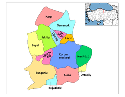
Country  Turkey
Region Black Sea Province Çorum Population – Total 45.730 Time zone EET (UTC+2) – Summer (DST) EEST (UTC+3) Postal code 19500 Area code(s) 364 Licence plate 19 Osmancık is a district of Çorum Province in the Black Sea region of Turkey, located at 59 km north of the city of Çorum.
Contents
Geography
Located on an important crossing of the River Kızılırmak on the ancient Silk Road to the orient, Osmancık has long had a strategic value, and is still today a popular stopping-place on the road from Istanbul to the Black Sea city of Samsun and further east.
Today Osmancık is known for its rice production, being especially suitable for a new strain of rice developed especially for the region by the Turkish Ministry of Agriculture and named "Osmancık-97".
The North Anatolian Fault zone runs right through the valley, and Osmancık is very vulnerable to earthquakes.
'
 Kızılırmak River and Koyunbaba Bridge
List of Neighborhoods
- YAZI MAHALLESİ
- ESENTEPE MAHALLESİ
- GÜRLEYİK MAHALLESİ
- YEŞİLÇATMA MAHALLESİ
- CUMHURİYET MAHALLESİ
- YENİ MAHALLESİ
- GEMİCİ MAHALLESİ
- HIDIRLIK MAHALLESİ
- KIZILIRMAK MAHALLESİ
- GÜNEY MAHALLESİ
- ŞENYURT MAHALLESİ
- KOYUNBABA MAHALLESİ
- ÇAY MAHALLESİ
- ÇİFTLİKLER MAHALLESİ
- EYMÜR MAHALLESİ
- KARAPINAR MAHALLESİ
- TEMENCE MAHALLESİ
- ULUCAMİİ MAHALLESİ
History
The area was settled by the Kayı clan of the Oghuz Turks as they migrated westwards into Anatolia from their heartland of Central Asia. Osmancık was one of the important destination points in the Ottoman period. Because of numbers of earthquakes the city could not keep its ancient architecture. In the last century there has been 4-5 heavy earthquakes. Being on the path of Kizilirmak made the city an important settlement point since early history. Osmancik was known as "Pimolisene" Roman and Byzantine era.
Population
Population by years Years City Center Villages Total 2008 24.678 26.486 51.164 2000 30.423 25.335 53.758 1990 21.347 31.143 52.490 1980 63.018 1970 53.849 1960 42.960 1950 1927 29.184 1907 29.473 1893 17.639 1831 4.349 Notable natives
- Osmancıklı İmamzade Halil Paşa - 15th century Ottoman statesman, in the court of Mehmed I.
- Osmancıklı (Amasyalı) Koca Mehmed Nizamüddin Paşa - 15th century Ottoman statesman.
- Pakçemüezzin Baltacı Mehmed Paşa - 18th century Ottoman statesman, rumoured to have been a lover of Catherine I of Russia.
- Gen. Ahmet Çörekçi - Former Head Commander of Turkish Air Forces
- Bekir Aksoy - Former Minister of The Government
Places of interest
- In the village of Ardıç to the west of Osmancık there is a road cut by the Ancient Romans through a rock named Çalınkaya.
- Koyunbaba bridge over the Kızılırmak, built in 1489.
- The Seljuk Turk castle of Kandiber, in the town centre.
- The Ottoman period tomb of Sufi mystic Koyunbaba.
- The Trojan war hero Achilles was said to have been finally buried on the hill of Adatepe.
External links
- District governor's official website
- District municipality's official website
- Osmancikgundem.com - City News Portal
- Osmancık Haber - Weekly Local Newspaper
- Osmancık - Weekly Local Newspaper
References
Template:Osmancık belde ve köyleri
Template:Çorum ilçeler
*
 Osmancık in Çorum Province (in the Black Sea region) of Turkey
Urban districts 
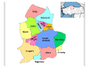
Rural districts RegionsAegean Black Sea Central Anatolia Eastern Anatolia Marmara Mediterranean Southeastern Anatolia Categories:- Districts of Çorum
- Black Sea Region
- Populated places in Çorum Province
- Osmancık
- Black Sea Region geography stubs


Wikimedia Foundation. 2010.