North Anatolian Fault

North Anatolian Fault
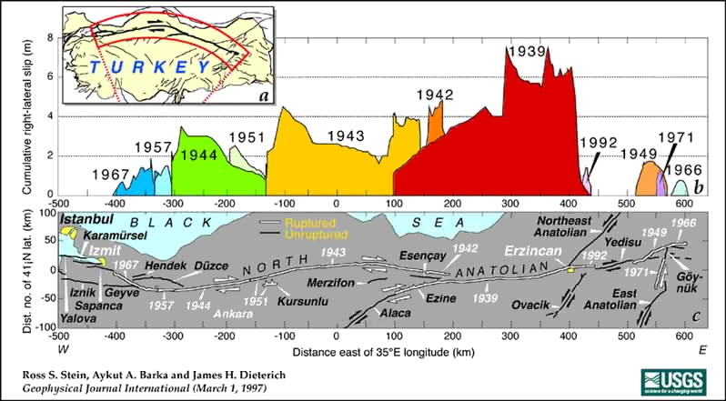
The North Anatolian Fault and slip magnitudes of earthquakes in the 20th century
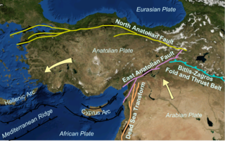
The North Anatolian and neighbouring faults covering most of Turkey

The North Anatolian Fault (NAF) (Turkish: Kuzey Anadolu Fay Hattı) is a major active right lateral-moving strike-slip fault in northern Anatolia which runs along the transform boundary between the Eurasian Plate and the Anatolian Plate. The fault extends westward from a junction with the East Anatolian Fault at the Karliova Triple Junction in eastern Turkey, across northern Turkey and into the Aegean Sea. It runs about 20 km south of Istanbul.

Significant earthquakes

Since the disastrous 1939 Erzincan earthquake, there have been seven earthquakes measuring over 7.0 on the Richter scale, each happening at a point progressively further west. Seismologists studying this pattern believe that earthquakes happen in "storms" over a number of decades and that one earthquake triggers the next. By analysing the stresses caused along the fault by each earthquake, they were able to forecast the shock that hit the town of İzmit with devastating effect in August 1999. It is thought that the chain is not complete, and that an earthquake will soon strike further west along the fault – perhaps in the heavily populated city of Istanbul.

Event Moment magnitude Casualties
1939 Erzincan 7.9 32,962 dead
1942 Niksar-Erbaa 6.9
1943 Tosya-Ladik 7.7
1944 Bolu-Gerede 7.5
1949 Karlıova 7.1
1951 Kurşunlu 6.9 50 dead, 3,354 injured
1957 Abant 6.8
1966 Varto 6.9 2,394 dead, 1,489 injured
1967 Mudurnu Valley 7.1 86 dead, 332 injured
1992 Erzincan 6.5
1999 İzmit 7.4 17,480 dead and 43,959 injured
1999 Düzce 7.2 894 dead

See also

External links


Wikimedia Foundation. 2010.

Игры ⚽ Поможем написать реферат

Look at other dictionaries:

  • East Anatolian Fault — The East Anatolian and neighbouring faults cover most of Turkey The East Anatolian Fault is a major strike slip fault zone in eastern Turkey. It forms the transform type tectonic boundary between the Anatolian Plate and the northward moving… …   Wikipedia

  • Anatolian Plate — The easterly side is a boundary with the Arabian Plate, the East Anatolian Fault, a left lateral transform fault.The southerly and southwesterly sides comprise a convergent boundary with the African Plate, manifest in compressive features of the… …   Wikipedia

  • Transform fault — (the red lines) A transform fault or transform boundary, also known as conservative plate boundary since these faults neither create nor destroy lithosphere, is a type of fault whose relative motion is predominantly horizontal in either sinistral …   Wikipedia

  • North American Plate —   The North American plate, shown in brown The North American Plate is a tectonic plate covering most of North America, Greenland, Cuba, Bahama …   Wikipedia

  • North Bismarck Plate — Map of the North Bismarck Plate (as Bismarck Nord ) and its neighbouring plates (in French). Where Manus is labeled it should be BSSL. The North Bismarck Plate is a small tectonic plate located in the Bismarck Sea off the northeast coast of New… …   Wikipedia

  • Asia — /ay zheuh, ay sheuh/, n. a continent bounded by Europe and the Arctic, Pacific, and Indian oceans. 2,896,700,000; ab. 16,000,000 sq. mi. (41,440,000 sq. km). * * * I Largest continent on Earth. It is bounded by the Arctic Ocean, the Pacific Ocean …   Universalium

  • Istanbul —   City   Top: Topkapı Palace – Hagia Sophia – Blue Mosque Center: Beyoğlu; …   Wikipedia

  • Earth Sciences — ▪ 2009 Introduction Geology and Geochemistry       The theme of the 33rd International Geological Congress, which was held in Norway in August 2008, was “Earth System Science: Foundation for Sustainable Development.” It was attended by nearly… …   Universalium

  • Geography of Turkey — Turkey is situated in Anatolia and Southeastern Europe (that portion of Turkey west of the Bosphorus is geographically part of Europe, and Anatolia is part of Southwestern Asia), bordering the Black Sea, between Bulgaria and Georgia, and… …   Wikipedia

  • Beşparmak Mountains — Beşparmak Dağı Mount Latmus Mount Latmus and the village of Kapıkırı among the ruins of Heracleia, with Lake Bafa in foreground. View is to the north …   Wikipedia

Share the article and excerpts

Direct link
Do a right-click on the link above
and select “Copy Link”