- İzmit
Infobox Settlement
settlement_type =
subdivision_type = Country
subdivision_name = TUR
timezone=EET
utc_offset=+2
map_caption =Location of İzmit within Turkey.
timezone_DST=EEST
utc_offset_DST=+3official_name = İzmit
 |thumb|right|300px
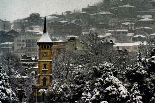
image_caption = İzmit Clock Tower
image_blank_emblem =
blank_emblem_type = Coat of Arms of Kocaeli Metropolitan Municipality
subdivision_type1=Region
subdivision_name1 = Marmara
subdivision_type2=Province
subdivision_name2 =Kocaeli
population_total = 248,424 |population_footnotes= [http://world-gazetteer.com/wg.php?x=&men=gadm&lng=en&dat=32&geo=-215&srt=npan&col=aohdq]
population_as_of = 2007
population_metro= 1411845
population_density_km2 = 400.6
area_metro_km2 = 3524
elevation_m = 100
pushpin_
pushpin_label_position =
pushpin_map_caption =Location of İzmit
pushpin_mapsize =
latd = 40
latm = 41
latNS = N
longd = 29
longm = 31
longEW = E
postal_code_type=Postal code
postal_code = 41xxx
area_code = (+90) 262
blank_info = 41|blank_name=Licence plate
website = [http://www.kocaeli.bel.tr/ Kocaeli Metropolitan
Municipality]İzmit (ancient
Nicomedia ) is a city inTurkey , administrative center ofKocaeli Province as well as the Kocaeli Metropolitan Municipality. It is located at theGulf of İzmit (the ancient "Gulf of Astacus") in theSea of Marmara , about convert|100|km|mi|0|abbr=on east ofİstanbul , on the northwestern part ofAnatolia . The city centre has a population of 248,424 (2007 census). The urban area has a population of 577,932 inhabitants and is part of Kocaeli Metropolitan Municipality, which has the same border as Kocaeli Province with a population of 1,411,845 inhabitants. İzmit (Nicomedia) was the eastern and most senior capital city of theRoman Empire between286 and324 , during theTetrarchy introduced byDiocletian . Following Constantine's defeat of co-emperorLicinius at theBattle of Chrysopolis (Üsküdar ) in324 , Nicomedia served as an interim capital city forConstantine the Great between324 and330 , until the nearbyByzantium was officially declared "Nova Roma" (later known asConstantinople , present-dayIstanbul .)Defining İzmit
The geological location of İzmit is between 40°-41° N and 29°-31° E, surrounded by the Gulf of İzmit at south, İstanbul and the Sea of Marmara at west, the
Black Sea at north, andSakarya at east.The city is mostly built on hill slopes because of the cramped area, while flat plains are located around the gulf, near the sea. This topographic structure divided the city in two different parts. The first part was created on flat plains, where the city center is also located. The railway and highway networks also pass from this area which is close to the Sea of Marmara. The second part was built on hills, with many historic houses from the Ottoman period in the old quarters.
Climate
The local climate, more temperate near the
Gulf of İzmit (Körfez in Turkish) and the Black Sea, more severe in the mountains, constitutes a transition between Mediterranean and Black Sea types; the typical urban summer here is hot and dry, the winter wet, however, Izmit and Marmara lack the refreshing summer breezes of the northern reaches, and can become humid.The highest recorded temperature in the city (11 Aug 1970) was 41.6°C , the lowest (4 Feb 1960) -8.7°C , while the yearly average stands at 14.8°C .
The Black Sea coast sees an annual rainfall of 1000mm., which gradually lessens south-eastwards: Izmit, for example, generally gets less than 800mm. The south-facing slopes of the Samanlı mountains, near Körfez, experience conditions similar to Black Sea coastal regions. Winter winds blow from the south to south-east, while in summer mainly south-easterly.
Features
There are numerous tourist attractions both in the city centre and its adjacent region, such as the remains of the ancient Acropolis, Agora, Amphitheater, Nymphaeum, Necropolis,
Demeter Temple and theHellenistic Üçtepeler Mound King Tombs, the Roman city walls, parts of the Temple ofAugustus , parts of the Palace and Arsenal ofDiocletian , Roman aqueducts and cisterns, a Byzantine fortress at the core of the Roman city walls, Orhan Gazi Mosque (1333), the 14th century Süleyman PaşaHamam , the 16th century Imaret Mosque and Pertev Paşa Mosque (1580) designed by the great Ottoman architectSinan , Pertev Paşa Fountain (1571), the 16th century Mehmed Bey Hamam, Saatçi Ali Efendi Mansion (1776), Tüysüz Fountain (1782), the early 19th century Fevziye Mosque, Kapanca Sokağı Fountain and Canfeda Kethüda Kadın Fountain (1827), the mid 19th century Sırrı Paşa Mansion, Kasr-ı Hümayun Palace and the French Theological School, Redif Barracks (1863), and the İzmit Clock Tower (1901).Economy
İzmit is an important industrial centre, with a large
oil refinery , and major paper and cement factories.Ford Motor Company has a plant here in a joint venture withOtosan , assembling the Transit/Tourneo and Transit/Tourneo Connect vans. It is also a transportation hub, being located on the main highway and railway lines between İstanbul andAnkara , and having a majorport .In the past few years the province has developed into a growth point for the automotive industry, receiving investment from Ford, Hyundai, Honda and Isuzu. Tyre and rubber products are produced to world class standard (Goodyear, Pirelli, Lassa and Bridgestone). Today Kocaeli province has grown 1200 industrial investments of which 108 have been established with international capital. Turkey’s largest enterprise, Tüpraş Petroleum Refinery Plant, is also located in Kocaeli, containing altogether 27% of the national chemical industry (petro-chemical included), including 18 of the 100 largest enterprises of Turkey are located in Kocaeli and paying 17-18% of the national tax revenues.
Financial Times affiliatedForeign Direct Investment Magazine nominated Kocaeli (the province of which İzmit is the capital) among the 25 "European Regions of the Future" for2006 -2007 . [ [http://www.fdimagazine.com/news/fullstory.php/aid/1544/EUROPEAN_CITIES___REGIONS_OF_THE_FUTURE_2006_07.html fDi Magazine: European Regions of the Future] ] The city was chosen along withAdana forTurkey , which scored the most points for cost effectiveness against Kocaeli's wider infrastructure, while Adana and Kocaeli tied on points for human resources and quality of life.The famous Turkish traditional sweet
Pişmaniye is a product of İzmit and theKocaeli Province .Transport
Being located along the commercially-active
Black Sea andMarmara Sea shorelines, Kocaeli boasts 5 ports and 35 industrial docks, making it an important communications centre, as well asAnatolia ’s farthest inland contact point and a gateway to global markets. The main transportation routes, the D-100 highway and the E-6 TEM (Trans European Motorway) which connects Europe with Asia, along with railway lines, form an intercontinental passage network. Kocaeli neighbours one of the world’s largest metropolitan centres,Istanbul . Its vicinity to Istanbul's two international airports (Sabiha Gökçen International Airport andAtatürk International Airport ) which are 45 and convert|80|km|mi|0|abbr=on away, respectively, from İzmit's city centre, provides national and international connections.Education
Kocaeli University was established in the city in 1992. The university has more than 50,000 students.History
In antiquity, the city was called Astacus or Olbia (founded
712 BC ). After being destroyed, it was rebuilt and founded byNicomedes I of Bithynia in264 BC under the name ofNicomedia , and has ever since been one of the most important cities in northwesternAsia Minor .Hannibal came to Nicomedia in his final years and committed suicide in nearby Libyssa (Gebze ). The historianArrian was born there. Nicomedia was the metropolis ofBithynia under theRoman Empire (see Nicaea), andDiocletian made it the eastern capital city of the Roman Empire in286 when he introduced theTetrarchy system. Nicomedia remained as the eastern (and most senior) capital of the Roman Empire untilLicinius was defeated byConstantine the Great in324 . Constantine mainly resided in Nicomedia as his interim capital city for the next six years, until in330 he declared the nearbyByzantium as "Nova Roma", which eventually became known asConstantinople (present-dayIstanbul ). Constantine died in a royal villa at the vicinity of Nicomedia in337 . Owing to its position at the convergence of the Asiatic roads leading to the new capital, Nicomedia retained its importance even after the foundation ofConstantinople .Until the lateXI century it was underByzantine rule. Than it was captured bySeljuk Turks , but soon after it was regained thanks to the succeses of thefirst crusade . After capture ofConstantinople in1204 the city, togeather with most of theBithynia province, became a part of theLatin Empire . It was recaptured by the Byzantynians around 1235 and stayed in its borders until first half of theXIV century .The city was conquered by the Ottoman Turks in
1338 .The earthquake of August 17,
1999 (magnitude 7.4) devastated the region, killing more than 19,000 people and leaving many more homeless. It took several years for the city to recover from this disaster; but the scars, especially on the memories of the residents - many of whom lost loved ones, can still be observed.Views from İzmit
Historic and modern sites in and around İzmit
*
Agora of İzmit
*Citadel of İzmit
*Temple of Augustus of İzmit
*İzmit Bay Bridge
* [http://paradisezoo.com/ Bayramoğlu Bird Paradise & Botanic Garden]ister Cities
* -
Kassel ,Germany since 1989* -
Ulsan ,South Korea * -
Székesfehérvár ,Hungary * -
Jinan ,China References
2. Nicomedia (Izmit Tarihi) by Avni Öztüre
External links
* [http://www.kocaeli.bel.tr/tr/04_album.asp?islem=catx&UstID=186&s=6 Official website of İzmit Metropolitan Municipality] tr icon
* [http://www.allaboutturkey.com/kocaeli.htm Informative site]

Wikimedia Foundation. 2010.