- Navajo Sandstone
-
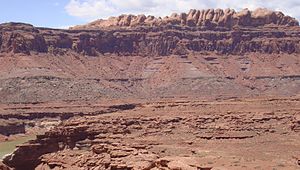
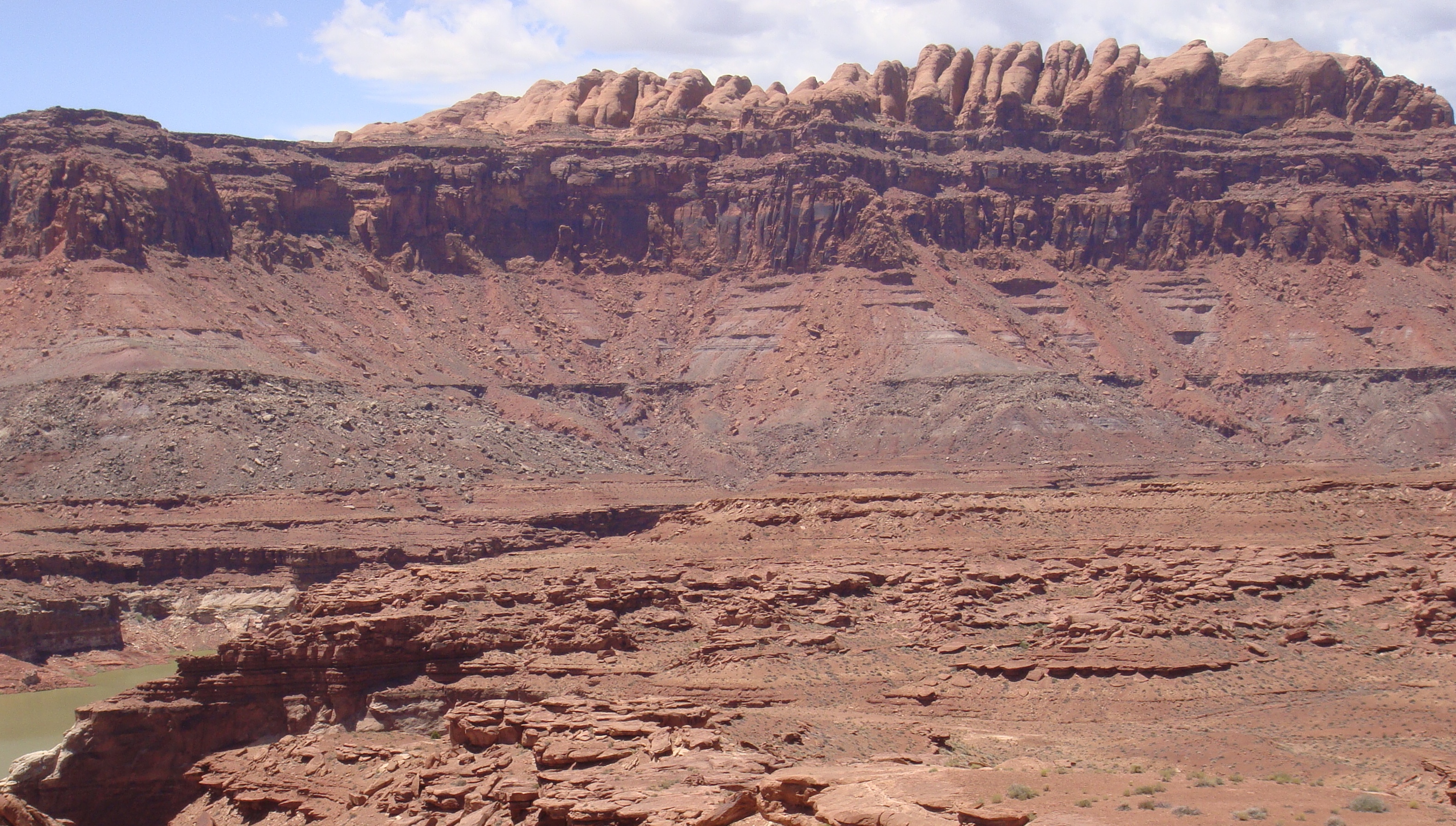
 A prominent cuesta of Navajo Sandstone rims the edge of the San Rafael Swell in eastern Utah.
Navajo Sandstone Type Geological formation Navajo Sandstone is a geologic formation in the Glen Canyon Group that is spread across the U.S. states of northern Arizona, northwest Colorado, and Utah; as part of the Colorado Plateau province of the United States.[1] This rock formation is particularly prominent in southern Utah, where it forms the main attractions of a number of national parks and monuments including Zion National Park, Capitol Reef National Park, Glen Canyon National Recreation Area, Grand Staircase-Escalante National Monument, and Canyonlands National Park. Navajo Sandstone frequently occurs above the Kayenta Formation and Wingate Sandstone, the other formations of the Glen Canyon Group. Together, these three formations can result in immense vertical cliffs of up to 2,200 feet (670 m). Atop the cliffs, Navajo Sandstone often appears as massive rounded domes and bluffs that are generally white in color.
Contents
Appearance and provenance

Navajo Sandstone frequently occurs as spectacular cliffs, cuestas, domes, and bluffs rising from the desert floor. It can be distinguished from adjacent Jurassic sandstones by its white to light pink color, meter-scale cross-bedding, and distinctive rounded weathering.
The wide range of colors exhibited by the Navajo Sandstone reflect a long history of alteration by groundwater and other subsurface fluids over the last 190 million years. The different colors, except for white, are caused by the presence of varying mixtures and amounts of hematite, goethite, and limonite filling the pore space within the quartz sand comprising the Navajo Sandstone. The iron in these strata originally arrived via the erosion of iron-bearing silicate minerals. Initially, this iron accumulated as iron-oxide coatings, which formed slowly after the sand had been deposited. Later, after having been deeply buried, reducing fluids composed of water and hydrocarbons flowed through the thick red sand which once comprised the Navajo Sandstone. The dissolution of the iron coatings by the reducing fluids bleached large volumes of the Navajo Sandstone a brilliant white. Reducing fluids transported the iron in solution until they mixed with oxidizing groundwater. Where the oxidizing and reducing fluids mixed, the iron precipitated within the Navajo Sandstone. Depending on local variations within the permeability, porosity, fracturing, and other inherent rock properties of the sandstone, varying mixtures of hematite, goethite, and limonite precipitated within spaces between quartz grains. Variations in the type and proportions of precipitated iron oxides resulted in the different crimson, vermillion, orange, salmon, peach, pink, gold, and yellow colors of the Navajo Sandstone. The precipitation of iron oxides also formed laminea, corrugated layers, columns, and pipes of ironstone within the Navajo Sandstone. Being harder and more resistant to erosion than the surrounding sandstone, the ironstone weathered out as ledges, walls, fins, "flags", towers, and other minor features, which stick out and above the local landscape in unusual shapes.[2][3]

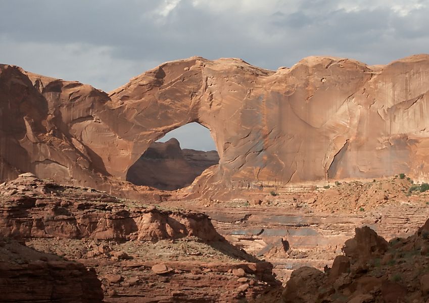
Stevens Arch, near the mouth of Coyote Gulch in the Canyons of the Escalante, is formed from a layer of Navajo Sandstone. The opening is 220 feet (67 m) wide and 160 feet (49 m) high. Age and history of investigation
The age of the Navajo Sandstone is somewhat controversial. It may originate from the Late Triassic but is at least as old as the Early Jurassic stages Pliensbachian and Toarcian.[1] There is no type locality of the name. It was simply named for the 'Navajo Country' of the southwestern United States.[4] The two major subunits of the Navajo are the Lamb Point Tongue (Cedar City area) and the Shurtz Sandstone Tongue (Kanab area).[5]
The Navajo Sandstone was originally named as the uppermost formation of the La Plata Group by Gregory and Stone in 1917. Baker reassigned it as the upper formation of Glen Canyon Group in 1936. Its age was modified by Lewis and others in 1961. The name was originally not used in northwest Colorado and northeast Utah, where the name 'Glen Canyon Sandstone' was preferred.[6] Its age was modified again by Padian in 1989.
Depositonal environment
The sandstone was deposited in an arid erg on the Western portion of the Supercontinent Pangea. This region was affected by annual monsoons that came about each winter when cooler winds and wind reversal occurred.
Places found
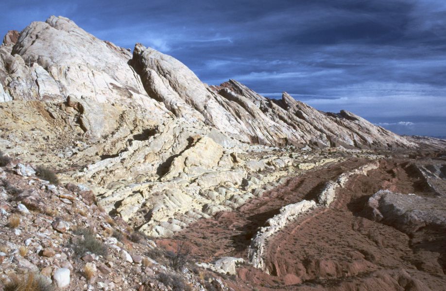
 The Permian through Jurassic stratigraphy of the Colorado Plateau area of southeastern Utah that makes up much of the famous prominent rock formations in protected areas such as Capitol Reef National Park and Canyonlands National Park. From top to bottom: Rounded tan domes of the Navajo Sandstone, layered red Kayenta Formation, cliff-forming, vertically-jointed, red Wingate Sandstone, slope-forming, purplish Chinle Formation, layered, lighter-red Moenkopi Formation, and white, layered Cutler Formation sandstone. Picture from Glen Canyon National Recreation Area, Utah.
Navajo Sandstone outcrops are found in these geologic locations:
- Colorado Plateau
- Black Mesa Basin
- Great Basin province
- Paradox Basin
- Piceance Basin
- Plateau sedimentary province
- San Juan Basin
- Uinta Basin
- Uinta Uplift
- Uncompaghre Uplift
The formation is also found in these parklands (incomplete list):
- Glen Canyon National Recreation Area
- Grand Staircase-Escalante National Monument
- Zion National Park
- Canyonlands National Park
- Capitol Reef National Park
- Arches National Park
- Dinosaur National Monument
- Colorado National Monument
Vertebrate paleofauna
Ornithodires
Indeterminate theropod remains geographically located in Arizona, USA.[7] Theropod tracks are geographically located in Arizona, Colorado, and Utah, USA.[7] Ornithischian tracks located in Arizona, USA.[7]
Color key
Taxon Reclassified taxon Taxon falsely reported as present Discredited taxon Ichnotaxon Ootaxon Morphotaxon Notes
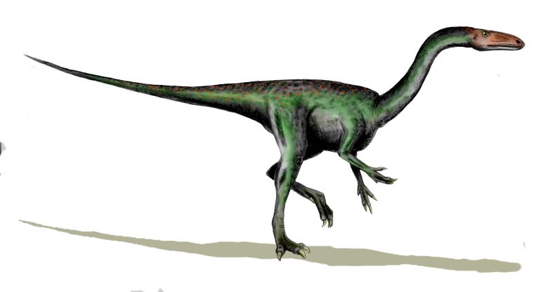
Uncertain or tentative data are in small text;crossed outdata are discredited.Ornithodires of the Navajo Sandstone Genus Species Location Stratigraphic position Material Notes Images Ammosaurus cf. major[7]
- Arizona[7]
Pteraichnus[8]
S. halli[7]
- Arizona[7]
"Partial postcranial skeleton."
Seitaad[9]
S. ruessi[9]
- Utah[9]
Iron oxide concretions (Moqui marbles)
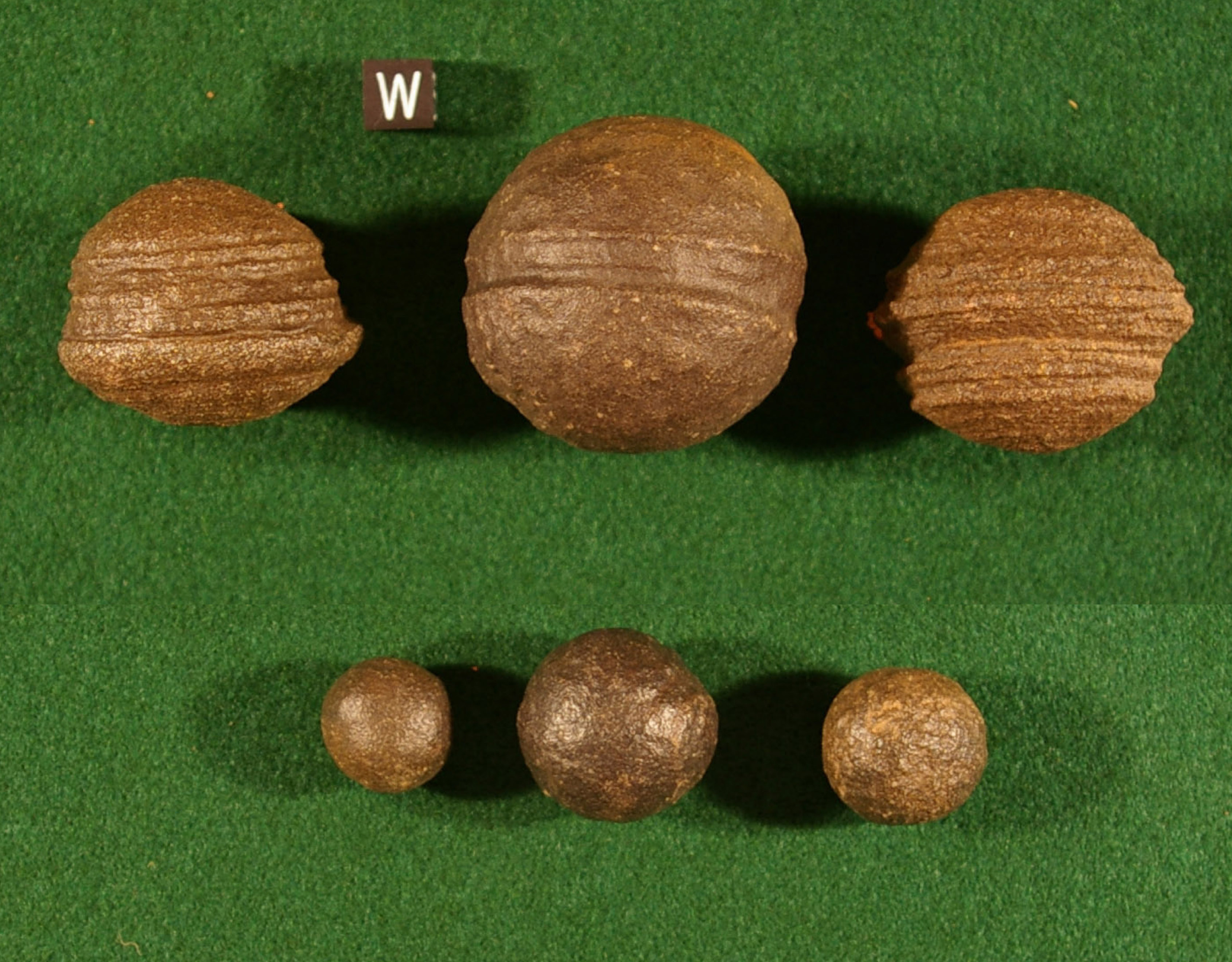
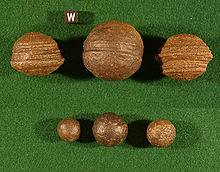 Moqui Marbles, hematite concretions, from the Navajo Sandstone of southeast Utah. Scale cube, with "W", is one centimeter square.
The Navajo Sandstone is also well known among rockhounds for its hundreds of thousands of iron oxide concretions. They are believed to represent an extension of Hopi Native American traditions regarding ancestor worship ("moqui" translates to "the dead" in the Hopi language). Informally, they are called "Moqui marbles" after the local proposed Moqui native American tribe. Thousands of these concretions weather out of outcrops of the Navajo Sandstone within south-central and southeastern Utah within an area extending from Zion National Park eastward to Arches and Canyonland national parks. They are quite abundant within Grand Staircase-Escalante National Monument.[2][3]
The iron oxide concretions found in the Navajo Sandstone exhibit a wide variety of sizes and shapes. Their shape ranges from spheres to discs; buttons; spiked balls; cylindrical hollow pipe-like forms; and other odd shapes. Although many of these concretions are fused together like soap bubbles, many more also occur as isolated concretions, which range in diameter from the size of peas to baseballs. The surface of these spherical concretions can range from being very rough to quite smooth. Some of the concretions are grooved spheres with ridges around their circumference.[2][3]
The abundant concretions found in the Navajo Sandstone consist of sandstone cemented together by hematite (Fe2O3), and goethite (FeOOH). The iron forming these concretions came from the breakdown of iron-bearing silicate minerals by weathering to form iron oxide coatings on other grains. During later diagenesis of the Navajo Sandstone while deeply buried, reducing fluids, likely hydrocarbons, dissolved these coatings. When the reducing fluids containing dissolved iron mixed with oxidizing groundwater, they and the dissolved iron were oxidized. This caused the iron to precipitate out as hematite and goethite to form the innumerable concretions found in the Navajo Sandstone. These concretions are regarded as terrestrial analogues of the hematite spherules, called alternately Martian "blueberries" or more technically Martian spherules, which the Opportunity rover found at Meridiani Planum on Mars.[2][3]
References
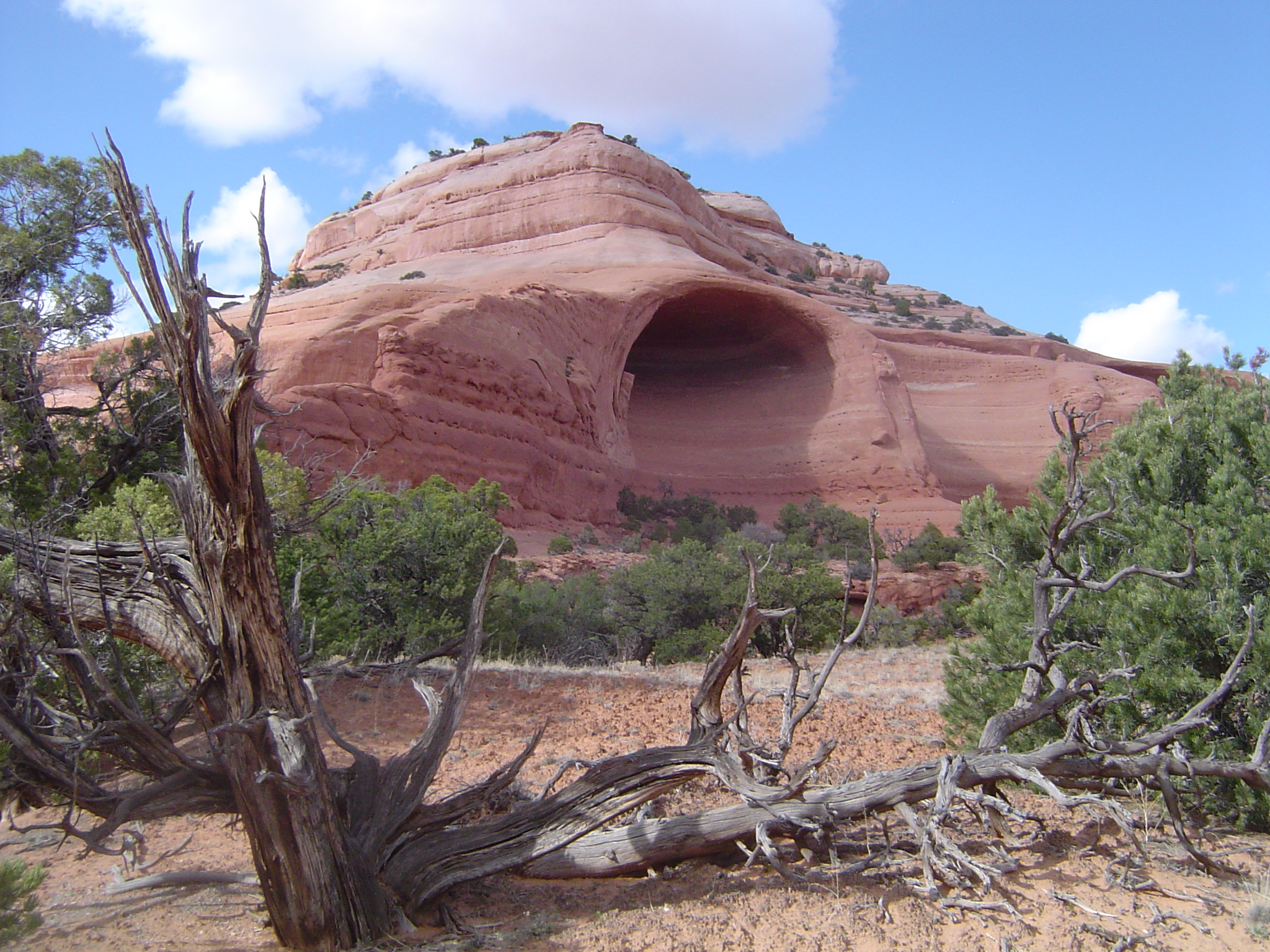
 The Golden Throne, a rock formation in Capitol Reef National Park. Though the park is famous for white domes of the Navajo Sandstone, this dome's color is a result of a lingering section of yellow Carmel Formation carbonate, which has stained the underlying rock.
Works cited
- Averitt, P., Wilson, R.F., Detterman, J.S., Harshbarger, J.W. and Repenning, C.A., 1955, "Revisions in correlation and nomenclature of Triassic and Jurassic formations in southwestern Utah and northern Arizona", American Association of Petroleum Geologists Bulletin, v. 39, no. 12, p. 2515–2524
- Baker, A.A., 1936, "Geology of the Monument Valley-Navajo Mountain region, San Juan County, Utah", U.S. Geological Survey Bulletin 865, 106 p., Also, U.S. Geological Survey Oil and Gas Investigations Map OM-168, and Bulletin 1087-D.
- Gregory, H.E. and Stone, R.W., 1917, "Geology of the Navajo country; a reconnaissance of parts of Arizona, New Mexico, and Utah", U.S. Geological Survey Professional Paper, 93, 161 p.
- Chan, M.A. and W.T. Parry, 2002, Mysteries of Sandstone Colors and Concretions in Colorado Plateau Canyon Country PDF version, 468 KB Utah Geological Survey Public Information Series 77:1-19.
- Chan, M.A., B.B. Beitler, W.T. Parry, J. Ormo, and G. Komatsu, 2005. Red Rock and Red Planet Diagenesis: Comparison of Earth and Mars Concretions PDF version, 3.4 MB. GSA Today, v. 15, n. 8, pp. 4–10.
- Lewis, G.E., Irwin, J.H. and Wilson, R.F., 1961, "Age of the Glen Canyon Group (Triassic and Jurassic) on the Colorado Plateau", Geological Society of America Bulletin v. 72, no. 9, p. 1437–1440
- Padian, K., 1989, "Presence of dinosaur Scelidosaurus indicates Jurassic age for the Kayenta Formation (Glen Canyon Group, northern Arizona)", Geological Society of America, Geology, v. 17, no. 5, p. 438-441
- Poole, F.G. and Stewart, J.H., 1964, "Chinle Formation and Glen Canyon Sandstone in northeastern Utah and northwestern Colorado, IN Geological Survey research 1964", U.S. Geological Survey Professional Paper, 501-D, p. D30-D39
- USGS: Colorado River Basin Stratigraphy - Navajo Sandstone Accessed 18 March 2006 (public domain text)
- Weishampel, David B.; Dodson, Peter; and Osmólska, Halszka (eds.): The Dinosauria, 2nd, Berkeley: University of California Press. 861 pp. ISBN 0-520-24209-2.
- Loope, D. B. and Rowe, C.M., 2003, long‐lived pluvial episodes during deposition of the Navajo Sandstone: The Journal of Geology, v. 111, p. 223-232.
Notes
- ^ a b USGS Accessed 18 March 2006
- ^ a b c d Chan and Parry 2002
- ^ a b c d Chan and others, 2005
- ^ Gregory, 1917
- ^ Averitt and others, 1955
- ^ Poole and Stewart, 1964
- ^ a b c d e f g h i Weishampel, David B; et al. (2004). "Dinosaur distribution (Early Jurassic, North America)." In: Weishampel, David B.; Dodson, Peter; and Osmólska, Halszka (eds.): The Dinosauria, 2nd, Berkeley: University of California Press. Pp. 530–532. ISBN 0-520-24209-2.
- ^ Lockley, M.; Harris, J.D.; and Mitchell, L. 2008. "A global overview of pterosaur ichnology: tracksite distribution in space and time." Zitteliana. B28. p. 187-198. ISSN 1612 - 4138.
- ^ a b c Sertich, J.J.W. and Loewen, M. (2010). "A new basal sauropodomorph dinosaur from the Lower Jurassic Navajo Sandstone of southern Utah." PLoS ONE, 5(3). doi:10.1371/journal.pone.0009789
Further reading
Internet - general
- U.S.G.S Lexicon of Colorado Plateau Stratigraphy
- Spatial Distribution in Macrostrat
- Avalanche Segregation and Stratification
- Eolian Pin Stripes in the Navajo Sandstone
- Navajo Sandstone Fossils
- Burrows and Vertebrate Tracks in the Navajo Sandstone
- Dry-Season Dinosaur Tracks in the Navajo Sandstone PDF Version (3.9 MB) of GSA poster
- Navajo Sandstone
- Jurassic Rain on the Navajo Desert
- Jurassic monsoons
- Tracing the Navajo sandstone
- Navajo Moqui Marbles and Martian Blueberries
- Bleaching of Jurassic Navajo Sandstone
Scientific publications
- Chan, M.A., and A.W. Archer, 2000, Cyclic Eolian Stratification on the Jurassic Navajo Sandstone, Zion National Park: Periodicities and Implications for Paleoclimate PDF version, 3.2 MB. in D.A. Sprinkel, T.C. Chidsey, Jr., and P.B. Anderson, eds., Geology of Utah's Parks and Monuments. Utah Geological Association Publication 28:1-11.
- Kocurek G. 2003. Limits on extreme Eolian systems: Sahara of Mauritania and Jurassic Navajo Sandstone examples. in M. Chan and A. Archer, eds., Extreme Depositional Environments: Mega End Members in Geologic Time. Geological Society of America Special Paper 370:43-52.
- Loope, D.B., and C.M. Rowe, 2003, Long-Lived Pluvial Episodes during Deposition of the Navajo Sandstone PDF version, 1.3 MB. The Journal of Geology 111:223-232.
- Loope, D.B., and C.M. Rowe, 2005, Seasonal Patterns of wind and rain recorded by the Navajo Sandstone PDF version, 7.4 MB. Canyon Legacy. 54:8-12.
- Loope, D., L. Eisenberg, and E. Waiss, 2004, Navajo sand sea of near-equatorial Pangea: Tropical westerlies, slumps, and giant stromatolites PDF version, 9.1 MB. in E.P. Nelson and E.A. Erslev, eds., Field Trips in the Southern Rocky Mountains, USA. Geological Society of America Field Guide 5:1-13.
- Loope, D.B., C.M. Rowe, and R.M. Joeckel, 2001, Annual monsoon rains recorded by Jurassic dunes PDF version, 284 KB. Nature. 412:64-66.
- Loope, D.B., M.B. Steiner, C.M. Rowe, and N. Lancaster, 2004, Tropical westerlies over Pangean sand seas PDF version, 340 KB. Sedimentology. 51:315-322.
- Rainforth, E.C., 1997, Vertebrate ichnological diversity and census studies, Lower Jurassic Navajo Sandstone PDF version, 3.9 MB. Unpublished masters thesis, Department of Geological Sciences, University of Colorado, Boulder.
- Tape, C., 2004, Cross-bedding in the Navajo Sandstone and implications for paleoclimate forcing, Zion national Park Site PDF version, 4.7 MB. in J.L. Kirschvink, ed., Field Trip to Colorado Plateau (southern Utah, northern Arizona, Permian-Triassic boundary). Division of Geological and Planetary Sciences, California Institute of Technology, University of California.
- Tape, C., 2005, The Lower Jurassic Navajo Sandstone: large-scale deposition and small-scale structures, Site: Glen Canyon Dam PDF version, 4.8 MB. in J.L. Kirschvink, ed., Field Trip to Colorado Plateau (southern Utah, northern Arizona, Permian-Triassic boundary). Division of Geological and Planetary Sciences, California Institute of Technology, University of California.

Wikimedia Foundation. 2010.