- Navajo Mountain
-
Navajo Mountain Naatsisʼáán (Navajo) 
Navajo Mountain and Lake Powell, looking southeast from the Kaiparowits PlateauElevation 10,388 ft (3,166 m) Location Location San Juan County, Utah /
Coconino County, ArizonaCoordinates 37°02′03″N 110°52′08″W / 37.03417°N 110.86889°W Geology Type Laccolith Last eruption Intrusive - N/A Climbing Easiest route Radio Towers Road Navajo Mountain (Navajo: Naatsisʼáán) is a peak in San Juan County, Utah, with its southern flank extending into Coconino County, Arizona. It holds an important place in the traditions of three local Native American tribes.
Contents
Geologic history
Navajo Mountain is a prominent free-standing laccolith, a dome-shaped body of igneous rock that intruded into sedimentary layers and lifted up the overlying layer. The igneous rock at the core of the mountain is wrapped in sedimentary layers. Such igneous intrusions have been exposed by erosion and well studied in similar mountain ranges on the Colorado Plateau, such as the Henry Mountains, the Abajo Mountains, and the La Sal Range.[1]
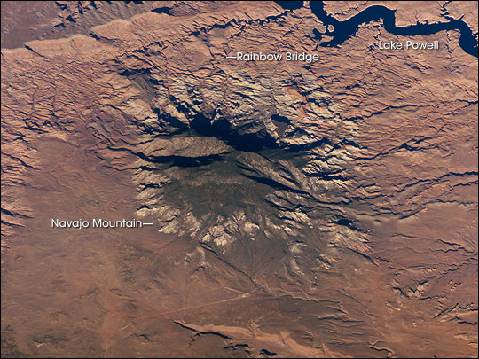
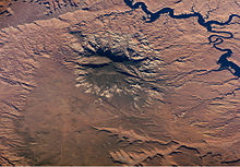 Navajo Mountain from space
The Colorado Plateau is made of mostly flat-lying layers of sedimentary rock that record paleoclimate extremes ranging from oceans to widespread deserts over the last 1.8 billion years. The peak of Navajo Mountain, at approximately 10,388 feet (3,166 m), is made up of uplifted Dakota Sandstone deposited during the Cretaceous Period (approximately 66-138 million years ago).[1]
Cultural history
The Navajo Mountain region has special cultural significance to the Navajo people, who know it as Naatsis’áán ("Earth Head" or "Pollen Mountain").[2] Together with Rainbow Bridge to the northwest, Navajo Mountain figures prominently as the first settlement area in western Navajo origin stories. Following the military defeat of the Diné (Navajo) by United States forces in 1863, the political landscape was changed by new boundaries and major physical alterations. The establishment of Rainbow Bridge National Monument (1910), and the filling of Glen Canyon by Lake Powell in 1963, has facilitated tourism of this previously remote region. Access to Navajo Mountain is still regulated by the sovereign Navajo Nation, and a permit is required to hike in the region. Climbing the mountain itself is forbidden. [3]
Before becoming part of the Navajo Nation, the area was inhabited by the Anasazi, or Ancestral Pueblans. Their descendants, the Hopi call Navajo Mountain Tokonave, or "Heart of the Earth".[4] Ruins in the area of Navajo Mountain are still strongly associated with certain Hopi clans, with priests still making pilgrimages to shrines in the area.[4]
Before 1933, when the area between the Colorado and San Juan Rivers and the Arizona border was added to the Navajo reservation, the area was known as the Paiute Strip, and the mountain itself was known as Paiute Mountain, due to the population of San Juan Paiutes living between the mountain and Monument Valley.[5]
Ecology
The Navajo Mountain beardtongue (Penstemon navajoa) is a rare plant limited mainly to the upper elevation slopes of Navajo Mountain.[6]
References
- ^ a b "Navajo Mountain, Utah". NASA Earth Observatory. http://earthobservatory.nasa.gov/Newsroom/NewImages/images.php3?img_id=17079. Retrieved 2006-05-02.
- ^ Rose Houk, The Mountains Know Arizona, 2005, Arizona Highways Books
- ^ http://www.navajonationparks.org/permits.htm
- ^ a b Courlander, Harold. 1971. The Fourth World of the Hopis: the epic story of the Hopi Indians as preserved in their legends and traditions. pp. 239. New Mexico University Press
- ^ Trimble, Stephen. 1993. The People: Indians of the American Southwest. pp. 536. School of American Research
- ^ Penstemon navajoa. The Nature Conservancy.
Categories:- Mountains of Utah
- Mountains of Arizona
- Native American history of Arizona
- Landforms of San Juan County, Utah
- Rock formations in Arizona
- Rock formations in Utah
- Landforms of Coconino County, Arizona
- Geography of the Navajo Nation

Wikimedia Foundation. 2010.