- Chakrata
-
Chakrata — city — Coordinates 30°41′N 77°52′E / 30.69°N 77.86°ECoordinates: 30°41′N 77°52′E / 30.69°N 77.86°E Country India State Uttarakhand District(s) Dehradun Population 3,497 (2001[update]) Time zone IST (UTC+05:30) Area
• 2,118 metres (6,949 ft)
Chakrata or Chakrauta (चक्राता) is a cantonment town in Dehradun district in the state of Uttarakhand, India.
It is situated between the Tons and Yamuna rivers, at an elevation of 7000–7250 feet, 92 km from state capital, Dehradun, it was originally a cantonment of British Indian Army. Due west lies Himachal Pradesh, and due east are Mussoorie (73 km), Garhwal.
Contents
History
The area was earlier known as Jaunsar bawar, a nearby village,[1] belonging to the Jaunsari tribe, which still has a marked presence in the surrounding villages.
A cantonment of British Indian Army, was established in 1866 by Colonel Hume of the 55th Regiment, British Indian Army,[2] and the troops and officers first occupied the cantonment in April 1869.[3]
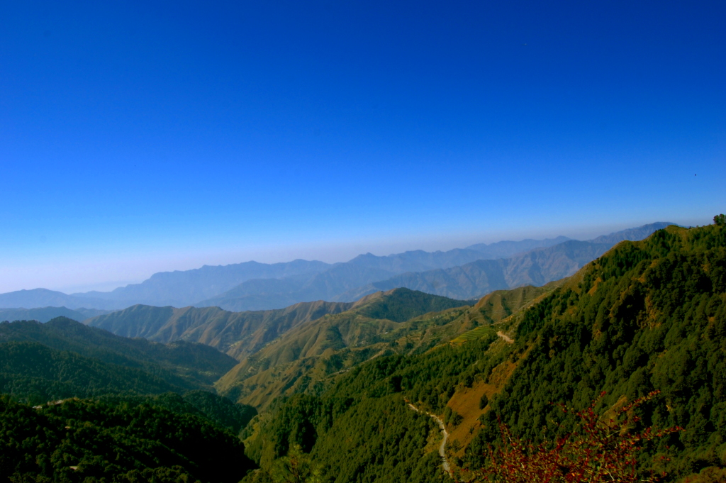
 View from Deovan of Chakrata
In 1901, Chakrata Tahsil was part of the Dehradun district, of United Provinces, with a collective population of 51,101, which consisted of the towns of Chakrata (population 1250) and Kalsi, with a population of 760 [1], which is most known for the rock edict of the Mauryan king Ashoka 2nd century BC, first discovered by John Forest, in 1860.[4]
The cantonment
Chakrata is an access-restricted military cantonment, and foreigners face severe restrictions in visiting. Notably, it is the permanent garrison of the secretive and elite Special Frontier Force, also known as Establishment 22 ( called "Two-Two"), the only ethnic Tibetan unit of the Indian Army, which was raised after the Indo-China War of 1962. Various kinds of weapons and survival training is also imparted by R&AW and other intelligence services in Chakrata, in support of various Indian foreign policy goals, especially pertaining to other countries in the Indian Subcontinent.
Operation Bluestar
The attack on Golden Temple was in plans even before the armed Sikh militants fortified it. Then GOC of the Indian Army, S. K. Sinha who was sacked at the last moment had criticized the Government's claim that the attack represented a "last resort", stating that the attack was planned a year and a half prior to the actual day of attack. S. K. Sinha and Mark Tully report that the army had been rehearsing the attack in a replica of the Golden Temple at a secret location near Chakrata Cantonment in the Doon Valley.
Local attractions
Chakrata can be reached from Dehradun via Mussoorie or Vikasnagar. Both routes pass through beautiful mountainous road. Travelling in the monsoon can be quite tricky as the area sees frequent road blockages due to landslides.
The area has an abundance of conifers, rhododendrons and oaks. The red rhododendrons are the most abundantly found in this region. A key attraction near Chakrata is the waterfall named Tiger Fall. A secluded -nearby, leafy hamlet of Deoban offers a panoramic view of the Himalayas stretching from Kinnaur to Garhwal and Kumaon.
The region also has a number of temples including ones at Hanol, Mahasu Devta Temple dedicated to Lord Mahasu (Though this is still a topic of discussion that Lord Mahasu is Lord Mahashiva or Lord Ramchnadra), Radina, Thaina, Indroli, Lakhwar, and Lakhamandal, on the banks of river Yamuna, known for its ancient Shiva Temple, which traces its existence to the legends of Mahabharata, the village also has several natural caves [5][6].
The alpine meadows of Mundali (2776 mts.), offers skiing opportunities, November to April.
There are approx. 2-3 basic private hotels in Chakrata, and some dhabas. Petrol and diesel are hard to come by (for civilians), but can be obtained in small quantities from local traders. The most famous hotel of chakrata is Hotel Himalayan Paradise and Hotel Snow View(estd 1936).
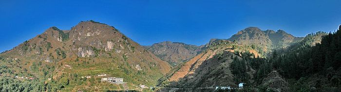 Panorama of Chakrata
Demographics
As of 2001[update] India census,[7] Chakrata had a population of 3497, belonging to the Jaunsari tribe.[6] Males constitute 62% of the population and females 38%. Chakrata has an average literacy rate of 75%, higher than the national average of 59.5%; w ith male literacy of 81% and female literacy of 65%. 12% of the population is under 6 years of age.
References
- ^ a b Chakrata Tahsil & Town The Imperial Gazetteer of India, 1909, v. 10, p. 125.
- ^ Chakrata Official website of Dehradun city.
- ^ Chakrata
 This article incorporates text from a publication now in the public domain: Chisholm, Hugh, ed (1911). Encyclopædia Britannica (11th ed.). Cambridge University Press..
 - ^ Kalsi Official website of Dehradun city.
- ^ Lakhamandal temple Official website of Dehradun city.
- ^ a b Excursions from Chakrata Garhwal Tourism.
- ^ "Census of India 2001: Data from the 2001 Census, including cities, villages and towns (Provisional)". Census Commission of India. Archived from the original on 2004-06-16. http://web.archive.org/web/20040616075334/http://www.censusindia.net/results/town.php?stad=A&state5=999. Retrieved 2008-11-01.
External links
- Chakrata Tahsil & Town, The Imperial Gazetteer of India, v. 10, p. 125., 1909
- Chakrata on wikimapia
- Chakrata Travel Guide
Cities and towns in Dehradun district Dehradun Chakrata · Clement Town · Dehradun · Dehradun Cantonment · Doiwala · FRI and College Area · Herbertpur · Landour · Mussoorie · Pratitnagar · Raipur · Rishikesh · Veerbhadra · Vikasnagar
Cities and towns
in other districtsAlmora · Bageshwar · Chamoli · Champawat · Haridwar · Nainital · Pauri Garhwal · Pithoragarh · Rudraprayag · Tehri Garhwal · Udham Singh Nagar · Uttarkashi
Categories:- Cities and towns in Dehradun district
- Tourism in Uttarakhand
- Cantonments of India
- Hill stations in India


Wikimedia Foundation. 2010.