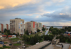
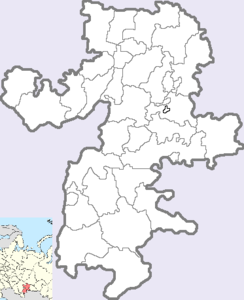
- Ozyorsk, Chelyabinsk Oblast
-
Ozyorsk (English)
Озёрск (Russian)- Town[citation needed] - 
A view of OzyorskCoordinates: 55°45′N 60°43′E / 55.75°N 60.717°ECoordinates: 55°45′N 60°43′E / 55.75°N 60.717°E Coat of arms Flag Administrative status Country Russia Federal subject Chelyabinsk Oblast Municipal status Urban okrug Ozyorsky Urban Okrug[citation needed] Administrative center of Ozyorsky Urban Okrug[citation needed] Head[citation needed] Alexander Kalinin[citation needed] Statistics Area 65,732 km2 (25,379 sq mi)[citation needed] Population (2010 Census,
preliminary)82,268 inhabitants[1] - Rank in 2010 201st Population (2002 Census) 91,760 inhabitants[2] - Rank in 2002 182nd Density 1 /km2 (2.6 /sq mi)[3] Time zone YEKST (UTC+06:00)[4] Founded 1945[citation needed] Postal code(s) 456780-456790[citation needed] Dialing code(s) +7 35130[citation needed] Ozyorsk or Ozersk (Russian: Озёрск) is a closed town in Chelyabinsk Oblast, Russia. Population: 82,268 (2010 Census preliminary results);[1] 91,760 (2002 Census).[2]
It was founded on the shore of the Irtyash Lake in 1945. Until 1994, it was known as Chelyabinsk-65, and even earlier, as Chelyabinsk-40 (the digits are the last digits of the postal code, and the name is that of the nearest big city; which was a common practice of giving names to closed towns). In 1994, it was granted town status and renamed Ozyorsk.
Contents
Economy
Ozyorsk was and remains a closed town because of its proximity to the Mayak plant, one of the sources of Soviet plutonium during the Cold War, and now a Russian facility for processing nuclear waste and recycling nuclear material from decommissioned nuclear weapons.
The plant itself covers an area of approximately 90 km² and employs about 15,000 people.
The Mayak is primarily engaged in reprocessing of spent nuclear fuel from the nuclear submarines and icebreakers and from nuclear power plants. Commercially, it produces cobalt-60, iridium-192, carbon-14 and establishes conversion production with use of radiative technologies applying wasteless technologies.
The town's coat of arms depicts a flame-colored salamander representing the ecological situation after the 1957 accident.
Southern-Urals Construction Department (ЗАО "Южноуральское управление строительства") is another major enterprise. Its activities include construction for atomic industry needs, production of concrete constructions and construction materials.
Main products of Plant of Wiring Products #2 (ЗАО "Завод электромонтажных изделий №2") are low-voltage devices for military-industrial establishments.
Radioactive contamination and the 1957 disaster
Main article: Kyshtym DisasterSince the late 1940s, Ozyorsk and the surrounding countryside have been heavily contaminated by industrial pollution from the Mayak plutonium plant.
The Mayak plant was one of the largest producers of weapons-grade plutonium for the Soviet Union during much of the Cold War, particularly during the Soviet atomic bomb program. Built and operated with great haste and disregard for safety, between 1945 and 1957 the Mayak plant dumped and released large amounts of solid, liquid and gaseous radioactive material into the area immediately around the plant, ultimately estimated to equal to between 2-3 Chernobyl explosions worth of radionuclides. Prior to 1956, much of the waste was dumped into the Techa River, which it severely contaminated along with residents of dozens of riverside villages such as Muslyumovo, who relied on the river as their sole source of drinking, washing and bathing water.
In 1957, the Mayak plant was the site of a major disaster in which an improperly-stored underground tank of high-level liquid nuclear waste exploded, releasing more radioactive contamination than Chernobyl and contaminating thousands of square miles of territory (see list of military nuclear accidents) now known as the Eastern Ural Radioactive Trace (EURT). The matter was quietly and secretly covered up, and few either inside or outside Russia was aware of the full scope of the disaster until 1980.
After 1957, official dumping in the Techa ceased, and the waste material was dumped in convenient shallow lakes near the plant instead, of which 7 have been officially identified. Of particular concern is Lake Karachay, the closest lake to the plant (now notorious as "The Most Contaminated Place on Earth") where roughly 4.4 exabecquerels of high-level liquid waste (75-90% of the total radioactivity released by Chernobyl) was dumped and concentrated in the 1/4 square mile lake over several decades.
In addition to the radioactive risks, the airborne lead and particulate soot levels in Ozyorsk (along with much of the Ural industrial region) are also very high—roughly equal to the levels encountered along busy roadsides in the era predating unleaded gasoline and catalytic converters—due to the presence of numerous lead smelters.
Education and culture
There are seventeen different cultural and public-service institutions.
There are sixteen secondary schools, two schools specializing in the English language, one gymnasium, physics-mathematics lyceum, three professional colleges, Southern-Ural Polytechnical College, Music College, Ozyorsk Engineering Institute (an affiliate of Moscow Engineering-Physical State University), and affiliates of Yekaterinburg's and Chelyabinsk's universities.
References
- ^ a b Федеральная служба государственной статистики (Federal State Statistics Service) (2011). "Предварительные итоги Всероссийской переписи населения 2010 года (Preliminary results of the 2010 All-Russian Population Census)" (in Russian). Всероссийская перепись населения 2010 года (All-Russia Population Census of 2010). Federal State Statistics Service. http://www.perepis-2010.ru/results_of_the_census/results-inform.php. Retrieved 2011-04-25.
- ^ a b Федеральная служба государственной статистики (Federal State Statistics Service) (2004-05-21). "Численность населения России, субъектов Российской Федерации в составе федеральных округов, районов, городских поселений, сельских населённых пунктов – районных центров и сельских населённых пунктов с населением 3 тысячи и более человек (Population of Russia, its federal districts, federal subjects, districts, urban localities, rural localities—administrative centers, and rural localities with population of over 3,000)" (in Russian). Всероссийская перепись населения 2002 года (All-Russia Population Census of 2002). Federal State Statistics Service. http://www.perepis2002.ru/ct/doc/1_TOM_01_04.xls. Retrieved 2010-03-23.
- ^ The value of density was calculated automatically by dividing the 2010 Census population by the area specified in the infobox. Please note that this value may not be accurate as the area specified in the infobox does not necessarily correspond to the area of the entity proper or is reported for the same year as the population.
- ^ Правительство Российской Федерации. Постановление №725 от 31 августа 2011 г. «О составе территорий, образующих каждую часовую зону, и порядке исчисления времени в часовых зонах, а также о признании утратившими силу отдельных Постановлений Правительства Российской Федерации». Вступил в силу по истечении 7 дней после дня официального опубликования. Опубликован: "Российская Газета", №197, 6 сентября 2011 г. (Government of the Russian Federation. Resolution #725 of August 31, 2011 On the Composition of the Territories Included into Each Time Zone and on the Procedures of Timekeeping in the Time Zones, as Well as on Abrogation of Several Resolutions of the Government of the Russian Federation. Effective as of after 7 days following the day of the official publication).
External links
- (Russian) Official website of Ozyorsky Urban Okrug
- (Russian) News, views and people (information portal of Ozyorsk)
- (Russian) Information portal of Ozyorsk
- (Russian) Website of Ozyorsk
- (English) Article about Ozyorsk and Mayak at uralpress.ru.
Administrative divisions of Chelyabinsk Oblast Administrative center: Chelyabinsk 
Cities and towns Asha · Bakal · Chebarkul · Karabash · Kartaly · Kasli · Katav-Ivanovsk · Kopeysk · Korkino · Kusa · Kyshtym · Magnitogorsk · Miass · Minyar · Nyazepetrovsk · Ozyorsk · Plast · Satka · Sim · Snezhinsk · Troitsk · Tryokhgorny · Ust-Katav · Verkhneuralsk · Verkhny Ufaley · Yemanzhelinsk · Yuryuzan · Yuzhnouralsk · Zlatoust
Districts Agapovsky · Argayashsky · Ashinsky · Bredinsky · Chebarkulsky · Chesmensky · Kartalinsky · Kaslinsky · Katav-Ivanovsky · Kizilsky · Korkinsky · Krasnoarmeysky · Kunashaksky · Kusinsky · Nagaybaksky · Nyazepetrovsky · Oktyabrsky · Plastovsky · Satkinsky · Sosnovsky · Troitsky · Uvelsky · Uysky · Varnensky · Verkhneuralsky · Yemanzhelinsky · YetkulskyBolshoy Kamen · Fokino · Gadzhiyevo · Krasnoznamensk · Lesnoy · Mezhgorye · Mirny · Norilsk · Novouralsk · Omutninsk · Ostrovnoy · Ozyorsk · Polyarny · Raduzhny · Sarov · Severomorsk · Seversk · Shikhany · Snezhinsk · Snezhnogorsk · Tryokhgorny · Uglegorsk · Vilyuchinsk · Zaozyorsk · Zarechny · Zelenogorsk · Zheleznogorsk · Znamensk
 Categories:
- Closed cities
- Cities and towns in Chelyabinsk Oblast
Wikimedia Foundation. 2010.


